10°


 22 April 2018
Skagi Peninsula

The Skagi Peninsula is located along Road number 1 on the way to Akureyri, AKA the capital of the North, and the famous and spectacular site of Myvatn. Located between Húnaflói Bay in the west and the Skagafjörður Fjord in the east, Skagi isn't the most well known tourist site, but there's plenty worth seeing.
Most travelers cross this desolate region without even stopping, but if you take the time to explore the peninsula, it is home to many remote and secluded landscapes where you can truly connect with nature.
At first glance, this region may seem a bit austere or even gloomy when the bad weather gets involved, but this tough exterior hides some truly sublime landscapes. There are some great tourist attractions for those who venture this far.
For hot spring enthusiasts, the Grettislaug pools in the south-east of the peninsula are a popular hot spring in northern Iceland known for being lost in the middle of nowhere.
Glaumbaer farm

Located along Road 75 a little north of Varmahlid, the Glaumbaer farm is on the outskirts of the peninsula. This is your chance to see traditional 19th century Icelandic farms, linked together by corridors, and one of the best-preserved historic sites in the country.
Now a museum, visitors can wander the 16 rooms within, some of which are furnished with period furniture. It's a fascinating museum with a rich collection that testifies to the living conditions of Icelandic farmers during the last centuries.
These houses are unique for their construction: wood became a rare commodity in Iceland, so the use of peat took over. This technique involves semi-buried constructions with thick layers of peat and grass to cover the roofs, providing excellent insulation. An added effect was that the farms blend into the landscape, quite literally.
Vidimyri

Vidimyri Church is considered to be a fine example of traditional Icelandic architecture. Located very close to Varmahlid village, you can't miss this unique building with its peat walls, grass roof and black-painted driftwood facade.
The current church was built in 1834 at the location of previous churches, and even incorporated some artefacts such as the altar dated 1616. The exterior gate is the original construction and allows access to the church and the cemetery, and houses 2 large bells. Note that the church is only open from June 1 to August 31 (12pm to 5pm, closed on Mondays), and admission, including to the cemetery, is charged during these opening hours.
For lovers of the great outdoors, the region has a huge range of nature activities including fishing, bird-watching, hiking, or rafting in the glacial rivers.
Kalfshamarsvik

At the extreme north-west of the peninsula lies Kalfshamarsvik. This small creek is surrounded by unique cliffs with spectacular basalt columns. You can walk around and observe the numerous bird colonies, and even have a picnic not far from the lighthouse to enjoy the view.
To get there, take Road 74 from Road 1 towards Skagaströnd, then follow gravel track 745 for about 23 to 25 km (allow 20 to 25 minutes). It is usually passable in a regular car in summer, but watch out for potholes and loose stones. Access is free and there is a car park at the start of the walk. A short loop of about 1 km (15 to 20 minutes) takes you past the basalt columns, the lighthouse (built in 1940) and the ruins of the old village, where signs, in Icelandic, mark the sites of the former houses.
- There are no toilets, café or shop: bring water and a snack. The nearest services are in Skagaströnd and Blönduós.
- Wear sturdy shoes, as the ground is uneven and often wet.
- Do not climb on the columns and keep away from the wall of curved columns near the beach, as pieces can break off. Keep your distance from the water too, as waves can be powerful.
- The track is poorly maintained in winter: snow and ice are possible from October to April, so summer is the best season to visit.
When fishing was allowed, a hundred inhabitants formed a community in Kalfshamarsvik until the 1940s, when it was completely abandoned; only a few dilapidated barns remain, a remnant of the past.
Ketubjörg cliffs
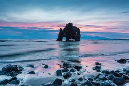
The Ketubjörg cliffs, around 122 m high, are the remains of an Ice Age volcano that the sea has eroded away. You'll see columns of basalt, seabirds nesting on the rock faces and small rivers tumbling straight into the ocean as waterfalls. A large sea stack, Kerling ("the old woman"), stands a little further to the north-east.
The cliffs lie roughly 45 to 50 km north of Sauðárkrókur. From Road 744, the gravel track 745 leads to the cliffs after about 26 km. Access is free, but there are no facilities on site, so bring water and food and start with a full tank. The track is often difficult, even impassable, from autumn to early summer, and fog can roll in quickly, so summer is the best season to visit.
Warning: the cliffs are eroding fast, and a large section collapsed in November 2019. Stay well back from the edge, where cracks are forming, and enjoy the view from a distance, especially if you have children with you.