The Volcanoes of Iceland
Iceland is the land of volcanoes. It's the second thing that comes to mind, after ice of course, when people think of this country.
The density of volcanic landscapes in Iceland is unmatched, and it is in the top five countries in terms of active volcanoes.
Iceland and its huge glaciers illustrate the constant battle between the heat of the deep earth and the cold of the skies above. It is the land of ice and fire that Martin could only dream of.
- Volcanism in Iceland
- Volcanic eruptions in Iceland
- Iceland's most famous volcanoes
- What to do and see near a volcano?
Volcanism in Iceland

Volcanic phenomena are ubiquitous in Iceland and while volcanic eruptions have sometimes had disastrous consequences, Icelanders are proud of these landscapes which actually bring in significant revenue.
In Iceland, there are no less than 130 active volcanoes and over 200 craters, which is huge considering the size of the country. By way of comparison, the United States and Russia taken together only have 170, and as you know these are huge territories!
These 130 volcanoes are the tip of the iceberg, as underground they are connected to 30 active volcanic systems that circulate magma among them.
Why are there a lot of volcanoes in Iceland?
Iceland's geology and geography explain this dense concentration of volcanic activity. Indeed, Iceland meets the two conditions necessary for volcanic landscapes to be formed. First, the country is located in a hot spot and, above all, the island is poised at the intersection of two tectonic plates, right on the Mid-Atlantic Ridge.
This ridge is in fact the tectonic border between the North American and Eurasian plates. These plates move away from each other at the whopping speed of 2 centimeters per year, which causes seismic activity, which causes magma to rise from the Earth's mantle.
To equalize pressure, the system regularly fills the space between the plates, which gives rise to volcanic eruptions.
Where are the volcanoes in Iceland located?

Map of the main volcanic areas in Iceland - Pinpin @Wikipedia
As the map above illustrates, the ridge crosses Iceland from north-east to south-west and as a result, the main volcanoes are located along this diagonal.
Only the western and eastern fjords regions are mostly inactive in terms of volcanism. If there are so few homes in southern Iceland, it's due to the intense volcanic activity and the dangers it represents: Icelanders have suffered great tragedies in learning these lessons.
Indeed, aside the actual eruption, in some cases this led to the sudden melting of glaciers, causing dramatic floods (jökulhlaups) in nearby habitations.
The types of volcanoes
All major types of volcanoes are present in Iceland:
- Red volcanoes with effusive eruptions
- Gray volcanoes with explosive eruptions
- Underwater volcanoes
- Subglacial volcanoes
Other phenomena include stratovolcanoes and eruptive faults.
The consequences of volcanic activity: geothermal energy

Volcanism is ubiquitous in Iceland and locals have adapted well over the centuries. One might argue that, today, Icelanders enjoy many benefits from volcanic activity.
Geothermal energy is the best example. No less than a third of Iceland's electricity is generated by geothermal power plants today. Hot water is drawn directly and heated via underground networks, which is why the water has that distinct sulphur smell. Aside the environmental aspect, Icelanders get their heating at very low cost.
The same applies to fruit and vegetable farming, as can be seen in Hveragerði, for example, with its many greenhouses, which grow tomatoes and even bananas in any season.
Finally, these volcanoes are known throughout the world and draw many visitors, generating a major tourist economy. Whether you want to scale a volcano or lounge in the famous hot springs, the country draws all kinds of people.
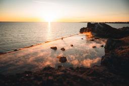
Hot springs obviously come from this geothermal heat raised from the subsoil. In some cases the hot water pools and riverbeds are natural features of the landscape, such as the Reykadalur or Landmannalaugar Rivers. But increasingly, building on their vast experience, Icelanders are developing large spa complexes with man-made hot water pools designed to specification, as is the case with the Blue Lagoon and Myvatn Nature Baths, for example.
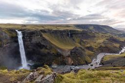
The consequences of volcanic activity: a unique landscape

If you look out the plane window over Keflavik airport, you'll quickly realize that the entire landmass was shaped by these volcanic systems. The huge lava fields are regularly covered thick moss beds, as is typically the case on the Reykjanes Peninsula near the airport, but you can see this almost everywhere on the island.
The black sand beaches found in particular in the south are typical of this volcanic activity, the beach sand mixing with ash from past eruptions.
Craters are present almost everywhere on the island and, in some parts of the country such as Landmannalaugar, the Westman Islands or Lakagígar, the volcanic colours of the rocky landscape are truly out of this world.
Volcanism takes many fantastical forms, shaping the very rock of mountains, and many of the wonders of Iceland are directly linked to this geological feature:
- Craters
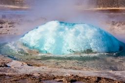
- Geysers
- Hot springs and geothermal energy
- Solfatars
- Bubbling pots
- Maars
- Lava and moss fields
- Basalt
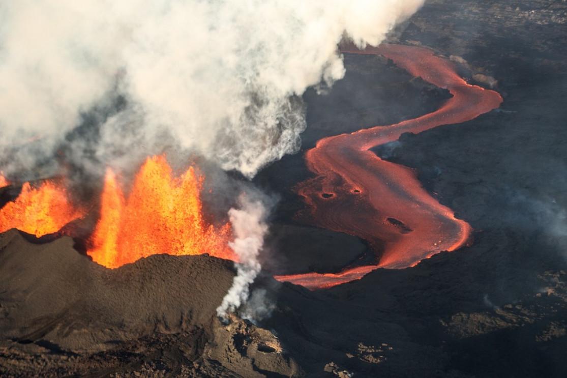
Volcanic eruptions in Iceland

The eruption of Barðarbunga in 2014
The frequency of eruptions
Iceland has some of the most frequent eruptions of any country in the world, with an average of between 10 and 20 eruptions per century, or at least one every 10 years. Some last only a few days, but some can go on for years!
Of course, some volcanoes are more tempestuous than others, as is the case of the dreaded Grimsvötn, which has experienced no less than 4 major eruptions since 1996. Others, like the no less dreaded Hekla, hve an average frequency of eruptions around 30 years, if we can trust the data that dates back to the 12th century. Finally, the killer Katla volcano, considered the most dangerous in Iceland, erupts on average once per century. The last eruption dates from 1918, so we are overdue for the next...
Can eruptions be predicted?
Yes, thankfully eruptions show characteristic warning signs: they are almost always preceded by significant seismic activity and a bulging of the Earth's crust because magma, when it accumulates near the surface, generates pressure which leads to earthquakes.
The vedur.is site has a section dedicated to volcanic activity, and issues alerts when a volcano shows signs of awakening.
There are many reliable seismological stations that detect and predict these activities, and in the event of an imminent eruption, the affected area is monitored and closed to the public.
The most important recent eruptions

The eruption of Barðarbunga in 2014
Everyone remembers the eruption of Eyjafjallajökull (Eyjafjöll to be more specific) in 2010, when ash clouds and smoke turned European air space into a no-fly zone for several days. But since then, Iceland has experienced a number of major eruptions. Here are some highlights of the last 50 years:
- Eldfell 1973
- Krafla 1980, 1981 and 1984
- Hekla 1980, 1991 and 2000
- Eyjafjöll in 2010
- Grimsvötn in 1996, 1998, 2004 and 2011
- Barðarbunga in 2014
- Geldingadalur (Fagradalsfjall) in 2021
- Meradalur (Fagradalsfjall) in 2022
- Litli Hrútur (Fagradalsfjall) in 2023
- Sundhnúkagígar (Grindavik) in 2023 and 2024
The largest and most devastating volcanic eruptions in local history are worthy of mention:
- Eldgjá in 984
- Laki in 1783
- Askja in 1875 and 1961
- Katla in 1918
- Hekla in 1947
The most devastating of these was undoubtedly that of Laki and its Lakagígar crater chain in 1783.
The eruption lasted 6 months and is the second largest eruption in recorded history, and it was a tragic period for Icelanders.
When a 25 km volcanic fissure opened unexpectedly, the resulting eruption was catastrophic, and the record-breaking emissions of sulphuric gases had serious climatic consequences. In fact, in less than a year, the eruption produced no less than 15 km³ of lava and generated two 60km-wide lava flows that eventually covered a total of no less than 565 km²...
The damage was not only dramatic for Iceland, which lost 10 thousand lives or 25% of its population due to the resulting famine, but also for the rest of Europe.
Historians also theorize that this eruption may have been one of the triggers of the French Revolution in 1789, as the climate change slashed harvests and led to famines in France.
For an idea of the scale, the eruption reduced the average global temperature by 4.5°C!
The most famous volcanoes in Iceland
Some of Iceland's most famous volcanoes include:
Some of those with the most destructive reputations include Laki of course, Katla and Hekla. Hekla also has the fearsome reputation of being the most unpredictable: when it last erupted, locals only had a 30 minutes warning...
Eyjafjöll was put on the map in 2010 when flights were grounded across the globe, which led to much media coverage, but this volcano is far from being the largest in Iceland.
For the literary fans, Snæfellsjökull may ring a bell thanks to Jules Verne who made it the gateway to the “center of the earth” in his novel.
Finally, the grimly-named Grimsvötn is probably the most active.
Things to do near volcanoes in Iceland

Winter in the Myvatn region
Some won't let you near them, while others are behind barriers, like Grimsvötn, for example, which is completely buried under the huge Vatnajökull ice cap. But the vast majority of Iceland's volcanoes are safe to be around, and even safe to climb!
There's quite a lot to see: lava fields, the solfatars and mud pots, and the geysers of Geysir!
The hikes

The Eldfell hike on the Westman Islands
In the south there are volcanoes and craters that are particularly suitable to hiking, such as Eldfell on the Westman Islands. Take a day to see the famous Lakagígar, a favourite local site as climbing the Laki offers a breathtaking view of the 25km chain of craters. Also in the south you will find one of the most beautiful hiking trails in Iceland, the mythical Fimmvörðuháls trek, which takes you to close to Eyjafjöll.
In the west, there are many hikes to explore on the Snaefellsjökull, and climbing the Grabrók craters nearby won't be wasted time. More recently, Geldingadalsgos and the Gelingadalur hike have become a must-see since the eruption in 2021.
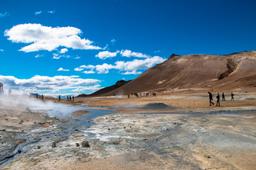
In the north and center of Iceland, the Askja hiking trail will unveil one of the most beautiful panoramas in Iceland. The Myvatn region, where the Krafla system is located, is brimming with volcanic phenomena such as the Hverir solfatares and mud pots, the Leirhnjukur lava fields, the Vití Maar or the Hverfjall crater.
Visiting a volcano
Iceland is the only country in the world where you can actually visit the inside of a volcano! Conveniently near Reykjavik, the magma chamber of the Thrihnukagigur volcano is open for business! An absolutely unique experience you won't soon forget.
Watch a molten lava show

After the 2010 volcanic eruption in Fimmvörðuháls (Eyjafjöll), a local couple had a crazy idea for a tourism concept. As volcanic eruptions are unpredictable with fatal consequences, and active sites are often forbidden to the public due to toxic smoke and the risk of burns, they created a show space where you can experience a lava flow in a secure environment. Just don't touch anything.
This is the only place in Iceland where you can be sure to see lava without risking your life.