Lakagígar: The Laki Craters
Laki is a volcanic fissure in Iceland made up of no less than 135 craters stretching over 25 km. This string of craters is named Lakagígar in Icelandic, which literally means “the Laki craters”.
Located in the south of the island between the huge Mýrdalsjökull and Vatnajökull glaciers, Laki is an absolutely unique landscape, the result of a cataclysmic eruption that took place in the 18th century.
- The Laki Fissure eruption of 1783
- How to get to Lakagígar and the Laki?
- Hike: The ascent of the Laki
The Laki Fissure eruption of 1783

Photo Credit: Alexander Bartels @fotolia
The Laki eruption began in 1783 and lasted almost a year, the second largest in local history which was a veritable disaster for Iceland. A 25 km volcanic fissure opened up spewing colossal amounts of lava as well as high emissions of sulfuric gases, which has serious climatic consequences. In fact, in less than a year, the eruption produced no less than 15 km³ of lava, which generated two 60-km wide lava flows that covered a mind-boggling 565 km² of land.
The damage extended much further than Iceland, which lost 25% of its population (about 10,000 deaths) due to the famine that struck in the wake this eruption. The rest of Europe was affected as well, and some historians suggest that this eruption may have been one of the triggers of the French Revolution of 1789, due to disastrous harvests and the famine that befell France as a result.
To give you a sense of scale, this eruption reduced the average global temperature by 4.5 °C!
Going to see the Lakagígar and the Laki: a journey
Today, the Laki region is very popular with tourists because the landscapes are absolutely unique and the remains of this eruption are visible in the terrain clear as day.
The Laki and Lakagigar are only accessible for tours in summer, as Trails F206 and F207 are completely closed in winter.
There are two ways to visit the Lakagigar: either by navigating there with your rental vehicle, or by taking the famous “Laki Loop” or “F207 Loop”, which is only possible via guided excursions.
Guided tour of the Laki
Some guided tours departing from Skaftafell will have you flying over the volcanic chain for an absolutely magical moment that can be enjoyed all year round, as aircraft don't have to worry road closures.
Alternatively, from Kirkjubaejarklaustur, the nearest town, you can book a tour to visit the Lakagigar via superjeep.

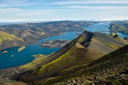
The craters of Lakagigar seen from the summit of Laki
The Laki in 4x4 via the F206 and F207 trails
For those who prefer forging their own path, you can get to Laki with a 4x4 rental vehicle as well. Very close to Kirkjubaejarklaustur in the south of Iceland, only one road leads to Laki, namely the F206, an off-road trail accessible to capable vehicles only. At the end of the trail it intersects in a “loop” with the F207, the famous “Lakagigar loop”. You can complete this circuit in 5 or 6 hours from Road number 1.
The F206
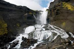
The F206 is just Road 206 for about 15 km before it becomes an off-road trail near the extraordinary Fjaðrárgljúfur canyon and the Fagrifoss waterfall a few kilometers away. Just after Fragrifoss you'll find your first ford crossing, which is not too much of a challenge at 30 cm in depth, and then you are officially on Trail F206 and things start to get interesting.
This trail is a steep and, after that first ford, you'll have to cross another 4 to reach the foot of the volcano. The current is generally quite forgiving and the depth rarely exceeds 30 to 40 cm, but don't fool around as they can still be dangerous.
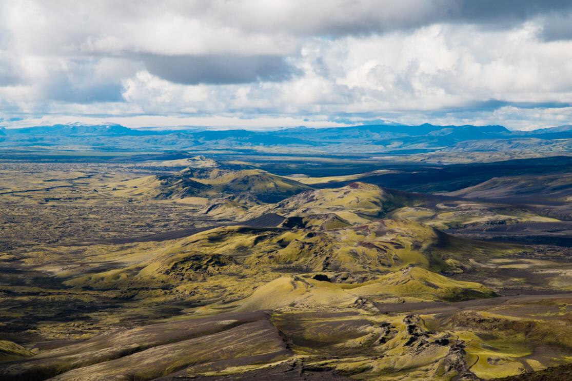
The landscape at this point is simply majestic, alternating between immense plains of black ash that contrast with fields of grass and moss that seem to glow bright green when the light is right. It is one of the most beautiful off-road trails in Iceland, equalled only by the F225 to Landmannalaugar and the F910 to Askja.

Ultimately, of the 5 fords, only 3 are actually challenging. The second ford is already an impressive one: it is very broad with independent streams you'll have to cross successively but its depth is mostly under 30 cm.
The last ford is the deepest and can sometimes be difficult or even impossible to cross safely depending on the weather (this is why it is critical to consult road.is before leaving for Laki).
5 km after this last ford, you must choose whether or not to do the full Laki loop by going east or west. Going west, you connect to the F207, the path east stays on the F206. Visitors generally head east on the F206 as they realize this really isn't for the faint of heart.
A few kilometers down the trail, the Lakagigar crater chain finally appears before you in all its glory after a total of 50 km of F206 and no less than 2.5 hours on this roller-coaster. The fissure of craters is a sight to behold and the highest peak, the famous Laki, is truly magnificent.
The F207
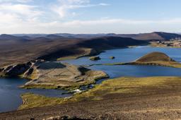
The loop via the F207 adds 30 km of track to the itinerary, and it's comparatively a smooth ride aside one major ford-crossing. It'll take an extra 1.5 hours to complete the loop via the 207, but this scenic route takes you right up to the volcanoes and craters. From this vantage in some craters you can peer down into clear blue water contrasting with the green of the moss.
There are numerous hiking trails along the off-road trail. A little further down the F207 lies Lambavatn, a large bright blue lake. A sign further on indicates the crater lake of Tjarnargigur, a magnificent maar that is matched in beauty only by the one in Kerið.

Like the final boss in a game, the F207 loop ends with an infamous ford-crossing, the deepest and meanest in the whole circuit. If conditions are not ideal it's very hard to cross, being 35-40 cm deep at the best of times. Many tourists stick to the F206 and skip the F207 just to avoid this ford. Most of the time, in summer, it goes well with a classic rental 4x4 or SUV type Duster. That said, this part of the loop has the best views so it's a gamble, but the pay-off can be worth it.
This will take a full day if you want to take your time enjoying the scenery, which we recommend, before returning to Kirkjubaejarklaustur for a total of about 6 hours driving and 2 hours on site.
Hiking: climbing the Laki

After 2.5 to 3 hours of driving, at the foot of the Laki, you can choose to hike up the biggest summit in the chain. From the top, you command a full view of this volcanic fissures, and it is a sight you won't forget. At this departure point there is a small parking lot and a cabin where local rangers shelter.
They are the ones who can best inform you about the condition of the off-road trail and the current depth of the fords, especially on the F207 part of the loop, so can help you decide whether to drive or hike on foot.
The hiking trail is also a looping circuit. It takes approximately 1H30 to 1H45 to complete the 3.5 km loop, so 45 minutes to reach the summit and about the same to come back down, and keep in mind it is quite steep, with about 300 m elevation in total.
From above, the 360° panorama is simply one of the most incredible vistas that Iceland has to offer if you are lucky enough to have clear skies. The chain of moss-covered volcanoes can be seen for what it is, an immense fissure. From this vantage, one can truly comprehend the scale of the devastating year-long eruption that occurred here. On a clear day, looking northeast, one sees right down the 25 kilometer fissure studded by its massive craters.
If you came to Iceland to see ravaged volcanic landscapes, then the Laki is simply the most impressive you will find, but as mentioned it really is a whole expedition you need to prepare ahead of time with up-to-date information on weather and road conditions.