The Lakes of Veiðivötn
Located north-east of the Fjallabak Nature Reserve, the Veiðivötn region is a scattering of 50 magnificent lakes that glimmer like an oasis in the black sand desert of the central highlands.
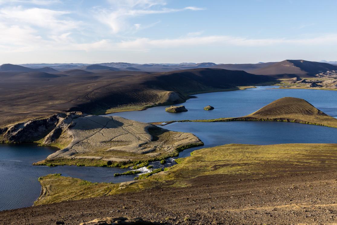
The 50 lakes of Veiðivötn are located in a valley, created quite recently on a geological scale, in 1477 when the Bárðarbunga volcano eruption blew open a string of craters that collected water, becoming maars over time. A maar is a crater with a lake in its heart, and Iceland is one of the best places in the world to see them.
How to get to Veiðivötn: the F228 trail
While known to be among the most beautiful parts of central Iceland, Veiðivötn is often overlooked by tourists preferring to visit Landmannaugar. Indeed, the lakes are very remote and hard to get to, with only one off-road trail: the F228. Don't even think about going there in winter as the F228 is generally only open at the end of June and closes from October on.
To get there you'll need a proper 4x4 vehicle, especially since the track requires crossing two fords, which are often fairly easy to pass but which can be quite deep and wreck or sweep away a city car. You'll be taking the F228 from the F26. Starting from Hrauneyar, follow the F26 towards Sprengisandur for 14 km (about 15 minutes) before you see the F228 going on the right. From here, it only takes 45 minutes to complete the approximately 20 km of trail to Veidivotn. The track, as is frequently the case in the region, is absolutely beautiful especially on a clear day and crosses an ashy desert. The ride is actually smooth and can be quite pleasant.
The first ford usually causes no issue, but the second, closer to the lakes, may be deeper. From here, a multitude of trails crisscross the surroundings of the lakes, allowing you to go around them as you see fit.
You should know that it is also possible to arrive by the F229 west of Tungnaarjökull, but very few travelers take this route.
Veidivotn: a breathtaking panorama

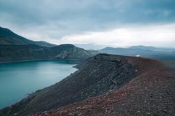
The Veiðivötn lakes cover an area nearly 20 km long and 5 km wide, and the lakes are connected to each other by rivers. The main one, the most famous lake, is called Tungnaá and flows into the Thjórsá, the largest river in Iceland. It is also in the Veiðivötn region that under the ground lies one of the branches of the tectonic rift that crosses Iceland, so there are also numerous volcanic fissures there.
There are very few tourists here, even in summer. The place is wild and mostly frequented by Icelander as it's a known fishing spot.
In fact, Veiðivötn means “fishing lakes”, and the place is considered to be a fishing paradise! As the name suggests, fish are aplenty there, mainly trout (healthy specimens, too, over 20 kg!) and arctic char.

News: Anna Veselova @shutterstock
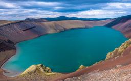
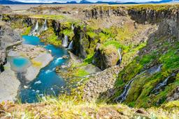
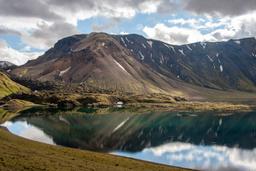
When you arrive in Veidivotn you won't believe your eyes. The landscapes of Veiðivötn can stay with you for a long time, with the contrast between the black sand and the blue waters of the various lakes combined with the hills and craters covered in green moss, all framed in streaks of ash.
There are exactly 50 lakes, and every single one has a name, as is always the case in Iceland. The largest is Litlisjór, but we can also mention Grænavatn, Skyggnisvtan, Stóra-Fossvatn, Skálavatn, Hraunvötn, Ónýtavatn, Snjóölduvatn or Arnarpollur.

On site, the best road to take really is in the eye of the beholder, and usually photographers wander from one lake to another in search of the perfect shot. Often, it is a question of finding one crater with a bit of elevation to get an panoramic view of the whole collection of lakes. For this reason it's hard to say how much time you'll spend on site. You can easily spend a full day there, but visitors often don't stay that long.
It's popular in the summer for a late afternoon visit to have a picnic and enjoy the silvery light of the midnight sun. In the evening, the light on the Veidivotn lakes is simply incredible, only really rivaled by Langisjor a little further south from Tungnaá.
Veiðivötn hiking trails

Some hiking trails are indicated near the fishing huts next to Lake Tjaldvatn, but most hiking enthusiasts simply wander around the lakes. Still there are some “official” hikes, of which the 28 and 29 (see map) are the best known.
Hike 29 heads south-west towards Lake Grænavatn and approaches the Tungnaá River for a nice view of its meandering shape.
Hike 28 is the most popular. It starts from Tjaldvatn and goes south towards Snjóölduvatn before looping north towards the other group of lakes, Ónýtavatn in particular. It takes about 16 km to achieve the complete loop, knowing that you can “cut it short” at any time to just aim straight for the car park.
Apart from a few locals who go around the lakes on mountain bikes, it is not unusual to not see anyone around the lakes in the evening, so you really can have this magical wild place to yourself.
Photo Credit top article : The lakes of Veiðivötn: Anna Veselova @shutterstock