Langisjór Lake
Langisjór is a large lake in the Landmannalaugar region in the south-west of Vatnajökull. Although not the most visited site in Iceland, the views in Langisjór are among the most beautiful on the island.
The massive Langisjór is one of the largest lakes in the country with a surface area of 27 km², a length of 20 kilometers and a width of almost 2 kilometers in places.
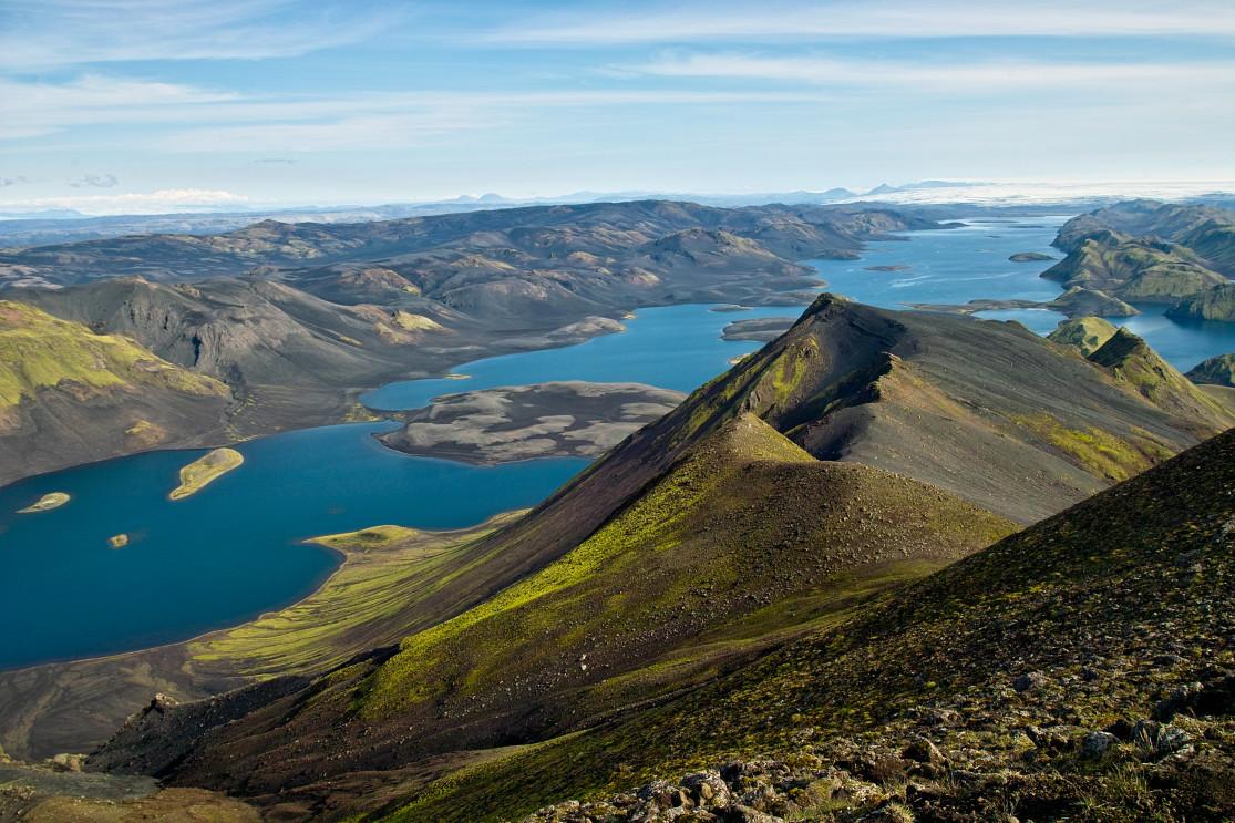
Langisjór: one of the most beautiful panoramas in Iceland

The breathtaking views of Langisjor - Jaroslav Jaroslavsson @shutterstock
Langisjór is located between two major mountain ranges: Fögrufjöll in the south, with the highest summit Sveinstindur rising to 1092 meters above sea level; and Tungnaárfjöll to the north with its Breiðbakur peak at 1018 meters. These mountains were formed during the ice age, most likely as a result of a subglacial eruption.
Langisjor itself is located 662 meters above sea level and was formed by volcanic faults collapsing the ground. Its water comes from nearby glaciers, and it plunges down 75 meters to the lake bed in places. The blue of its water contrasts beautifully with the green mountains that surround it for a truly breathtaking view, especially in good weather. The colors reflected on the lake also change depending on the light and the time of day.

The breathtaking views of Langisjor
The best place to admire this panorama is from the summit of Sveinstindur, which is fairly easy to climb (400 meters of elevation from the lake). The view from up there is unlike anything you've ever seen, and on a clear day you can even make out several glaciers: Öræfajökull, Langjökull or even Hofsjökull.
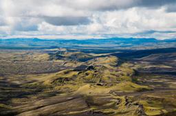
From this vantage point, looking east, you can admire the Fögrufjöll Range and the meanders of the Skaftá River, behind lies the Lakagigar Range and the famous Laki crater.
How to get to Langisjor
To admire this majestic but completely isolated landscape, the road is a bit complicated, but even that is worth it as the drive itself takes you through truly magical places. To get there you'll need a 4x4 vehicle, and it's really not a good idea to try and get there in winter, as the trail leading there is closed at this time of the year.
Once you've made sure it's open, and you have the right car, you can take the F235 trail from the F208 south of Landmannalaugar. There are two ways to get to Langisjór depending on the point of origin:
- Take the F208 south between Vik and Kirkjubaejarklaustur, then turn right onto the F235
- Take the F208 from Landmannalaugar and turn left onto the F235
There are smaller, more difficile trails to get there, especially from the north, but these two above are the most used roads Langisjór.
Access from the south
From road number 1, it takes just under 1 hour to make the 50 kilometers to Eldgja. The track is not too challenging and there is only one real ford to cross before joining the F235.
After exiting road number 1 onto the 208, it's a smooth drive down the dirt road for 16 kilometers before turning into the F208 track. That's when it gets off-road and quite bumpy for 24 kilometers.
Access from the north via Landmannalaugar
Only 30 kilometers separate the Landmannalaugar car park and the intersection with the F235, and this track is absolutely beautiful, but you'll have to work for it.
There are numerous fords between Landmannalaugar and the intersection and it takes 1 hour to make the 30 km. The fords are not necessarily deep, but they are numerous, so it slows you down.
The F235

The magnificent F235 track that leads to Langisjór
From the intersection, this magical trail begins with 23 kilometers of magnificent sandy track cutting through a vivid green and black desert of moss and ash (see photo above).
The track is like another planet entirely and includes several small fords, none of which should pose any challenge.
On site: Langisjor hikes and treks

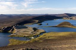
Langisjór from west side
There are no signs of civilization in this area except for the Langisjór hut, the starting point of a few local hiking trails.
You can spend time around the hut and take a few photos, but there's not much to see so you can continue along a bumpy trail that runs along the lakeshore until you reach the north of Langisjór near the impressive Tungnaárjökull.
The Sveinstindur summit
This is a must-do! Some tourists are happy taking a casual walk along the lakeside to the Fögrufjöll mountain range, but the real treat is to hike to the top of Sveinstindur to admire the 360° panorama of the region and one of the most beautiful views in Iceland.
Starting from the Sveinstindur hut with its red roof, it takes 2H30 to 3H to complete the round trip to the summit and back down (6.4 kilometers in total). The path is very well indicated and is not that difficult, despite the elevation (about 600m) and steep ascent as you approach the summit. You have to be in good shape to handle it but the show is well worth the effort.
The Landmannalaugar - Langisjor trek
There is also an infamous 6-day trek that totals about 115 kilometers between Landmannalaugar and Langisjór that follows this itinerary:
- Landmannalaugar - Hrafntinnusker (18 kilometers - 8H)
- Hrafntinnusker - Strútur (21 kilometers - 8H)
- Strútur (18 kilometers - 7H)
- Strútur - Alftavötn (21 kilometers - 8H)
- Álftavötn - Skælingar (18 kilometers - 8H)
- Skælingar - Svestindur (16 kilometers - 7H)
Top Article pic : Langisjór from the Svestindur summit - Jaroslav Jaroslavsson @shutterstock