Landmannalaugar: Travel guide
The Landmannalaugar region is among the most beautiful in the country and an unmissable stop for any hiking enthusiast in Iceland.
Colourful rhyolite mountains, volcanic landscapes, shadowy skies, marvellous hiking trails and hot springs are but a few of the spectacular experiences in store for you.
Landmannalaugar is a geothermal zone lost in the southern highlands of Iceland in the Fjallabak Nature Reserve. This nature reserve was created in 1979 and extends over nearly 500 km². Camping is strictly regulated in this wild area.
- Landmannalaugar and the Fjallabak reserve
- The geological features of Landmannalaugar
- Sleep near Landmannalaugar
- How and when to go to Landmannalaugar?
- Hikes and sites of interest
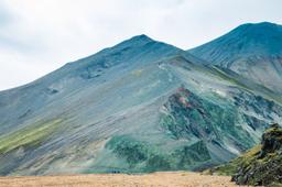
Landmannalaugar and the Fjallabak Nature Reserve

Landmannalaugar from the Bláhnúkur summit - Sortino @Unsplash
This lunar landscape was carved out of the rock by the Torfajökull volcano and its various eruptions. These events are older than time: the rocks found in the region are 8 to 10 million years old. The most recent eruption dates back to 1480 and gave us the Laugahraun lava flow and the Ljótipollur crater.
Fjallabak, literally “back of the mountain”, owes its name to the local deeply ravaged mountain range and its bottomless valleys.
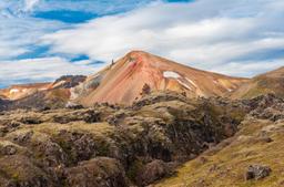
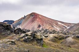
The geological features of Landmannalaugar

Brennisteinsalda - Fyle @fotolia
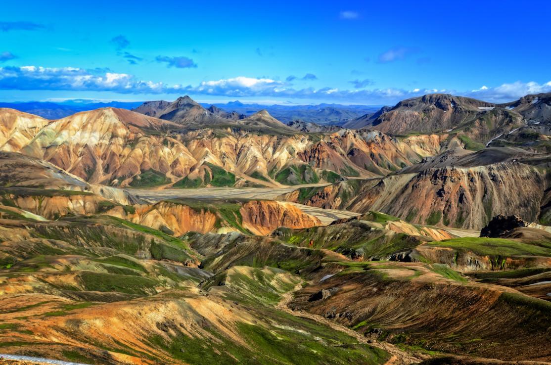
What strikes the eye when you approach Landmannalaugar and enter Fjallabak are the colors and the contrasts. Initially green and black, the mountains approaching Landmannalaugar explode into a chromatic delight: shades of yellow, sulfur, orange, pink, and sometimes even the blueish tone of rhyolite, which contrast with the jet black lava flows. Truly amazing sights.
The Rhyolite Mountains
The Rhyolite Mountains are the most striking feature of the landscape. The colours are reminiscent of a composition, as if imagined by an artist. The beautiful orange hues of the Barmúr Mountain near the Landmannalaugar contrast with the black and blue of Bláhnúkur.
Bláhnúkur, the “blue peak” rises to 940 m and is part of the Torfajökull Range. Very close to him, Brennisteinsalda, the “sulfur wave”, at the height of 855 m, offers a whole range of colors: rust red, sulfur yellow, blue, and black of cooled lava, vivid green lichens. Smoking fumaroles at the foot of Brennisteinsalda complete the picture.
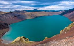
The lakes
Two lakes are located near to Landmannalaugar, namely Frostastaðavatn and Ljótipollur. Frostastaðavatn is ringed by a red and black mountain range that testifies to past volcanic activity. These colors contrast with the green of the lake at its feet.
Ljótipollur, on the other hand, is located a little further north and is one of the best known lakes in the region. Its dark blue waters are shored by red and green streaks. This shallow lake was born of an eruption dated back to 1477 that formed the crater with a diameter of 1500 meters.
While it takes some travel to get there, the Veiðivotn lakes are also a must see in the region. And a little further south we find the beautiful lakes of Langisjór and its world-class panoramas, known throughout the country.
The hot springs

Literally “the hot bath for locals”, Landmannalaugar is a small oasis in the middle of the highland desert, known in part for its mythical hot spring. It is one of the most pleasant spa destinations in the country. Firstly, because the hot water river is located near the Landmannalaugar campsite and surrounded by breathtaking panoramas of rhyolite mountains. Second, because naturally heated waters reach an ideal temperature of 36 to 40 degrees all year round, which gives hikers the opportunity to relax after several hours (or several days) of walking.
The Lava Fields
There are 3 lava fields in Landmannalaugar: Hrafntinnuhraun, Namshraun and Laugahraun, which is the best known and the most recent. These lava fields surround the various rhyolite mountains and their black color contributes to the otherworldly atmosphere. The flow starts at the foot of Brennisteinsalda and extends to its feet, blocking the small valley of Vondugil as if to force the Námskvísl stream to flow against the Suðúrnamur mountain. The Laugahraun hike is one of the most beautiful trails in the area.
Sleep in the Landmannalaugar region

Landmannalaugar Campground - Kushnirov Avraham @AdobeStock
Known throughout the country, this campsite is the only accommodation available on site.
Many tourists stay in the region for several days to enjoy longer hiking trails, and in this wilderness one has no choice but to camp out. You can make reservations to stay on the Ferðafélag Íslands via the website of the “Iceland Touring Association”: https://www.fi.is/en
This large campground has room for all to pitch a tent at the foot of the mountains with a lovely hot water river. Overall, the campsite is quite well-equipped. A large two-story cabin located in the center offers various amenities (bunk beds, kitchen, storage) and there are several separate sleeping cabins. Sanitary facilities are in a separate, heated building and an open kitchen is also available.
There are limited accommodations options in this area, in fact only 2! One on the road north on the 208, the other heading to Eldgja on the F208.
The nearest village, in this case Hrauneyar in the north, has a hotel called the Highland Center. It is an hour's drive north on the 208 (see the map of Landmannalaugar below in the article). Due to it's excellent reputation, this hotel is quickly full in summer and it is often necessary to book well in advance. Also, as it is perfectly located and there are very few accommodations in the area, it is rather expensive.
Further south, the other alternative is the Hólaskjól Cabin near Edlgja (7 km). It is ideally located for travelers who want to continue their adventure heading south on the F208 via Langisjor and the Eldgja fault. The cabins are very well maintained and the establishment is renowned in the region.
Be aware that you will have to travel across fifteen fords (see the chapter below on the F208 South) but it is well worth the effort as the F208 South is one of the most beautiful trails in the country.
How and when to get to Landmannalaugar?

The F225 track that leads to Landmannalaugar
Located 180 km from the capital Reykjavík, Landmannalaugar is not the most accessible place in the world, but it's worth the trip. You can drive there only between June and September and only if weather conditions allow. You can get there in winter but only with an organized excursion (see chapter on organized excursions). The site is therefore mostly visited in summer and is only accessible by 4x4 vehicles.
Many sources online claim that the area is accessible via the 208 North in a traditional vehicle, and while this is technically true, it is actually prohibited. Most car rental companies will not cover any damages incurred on a Landmannalaugar track with a traditional vehicle. It is essential to check with your rental company before trying to brave the elements.
There is a ford at the entrance to the Landmannalaugar campsite but as visitors can park their vehicle a few meters upstream, few people cross it as it is deep and easily avoided.
The different routes that lead to Landmannalaugar
Finally, in 4x4 vehicles, there are 3 ways to reach Landmannalaugar via 2 off-road trails:
- The F225
- The 208 North
- The F208 South
The F225 track
The F225 is one of the 3 most beautiful trails in Iceland but it is not the easiest and there are several fords along the way. The start of the trip is no problem, the splendid landscapes of the Fjallabak reserve appear soon after leaving route 26. The large volcano Hekla will be visible on the right, followed by a desert of ashes and lava fields.
The first difficulties began a dozen kilometers after turning off onto the F225, when you reach the first ford to cross.
As with all trail crossings, it is essential to know how deep the fords are. While the F225 crossings are often quite easy, 2 of them may be quite risky. In total, there will be 3 fords before reaching the crossroads with the F208 track. It takes a good hour to reach the end of the F225, but it's definitely worth it!
The 208 North
This is the route preferred by most tourists because it is the easiest and fastest (count 1 hour between the base camp and Hrauneyar). The 208 begins just after the village of Hrauneyar along route 26, and only becomes a Highland Road, the F208, after Landmannalaugar heading south.
The first leg of the 208 is therefore quite simple and does not include any ford-crossings to Landmannalaugar. The road is sometimes rough, of course, with a bit of corrugated portions that make for a very bumpy ride. Although less spectacular than the F225, this route still offers beautiful sights.
The F208 south
When you are in the South on the Vik side, one is easily tempted to “cut” straight across the slopes to reach Landmannalaugar.
While possible, the F208 between Vik and Landmannalaugar is a high-difficulty trail with about fifteen fords to cross). It takes no less than 2 hours to get from road number 1 to the car park, with 1 ford that can be important near Eldgja. The route is superb and alternates between mountains, ash desert and lakes.
The famous site of Eldgja is also located along this trail and you can reach the mythical Langisjor lake to the East via the F235.
Weather and trail schedule

Any expedition to Iceland along the off-road trails requires research on the road.is website before hitting the road. A return trip to Landmannalaugar is a two-hour affair, so it's best to be prepared so you can enjoy the sights without a worry. This is a high-altitude region and the weather changes quickly on site, so be sure to consult the base camp information point before embarking on a long hike.
Trails 208 and 225 leading to Landmannalaugar usually open in mid-June, but they may not open until early July. Here is an average estimate of trail schedules sourced from road.is (see image).

Reach the site by bus
You can also get there by bus. The site https://icelandbybus.is offers a daily Reykjavík / Hveragerði / Selfoss / Hella / Leirubakki / Landmannalaugar line between June 10th and September 15th. The bus leaves at 7:15 in the morning to arrive at midday. For day trips, the return bus departs at 6 pm, which gives you 6 hours to hike before returning around 9:30pm to Reykjavík.
Additional information: The bus in Iceland
Organized excursions
Many visitors prefer organized excursions to Landmannalaugar to avoid dealing with transport issues and to be able to visit outside the summer period. Here are a few examples:
- Day trip all year round to Landmannalaugar
- Landmannalaugar and Hekla Superjeep Day Trip
- Landmannalaugar Superjeep Day Trip
- Famous 5-day Laugavegur (Landmannalaugar Thorsmork) trek
- Famous 7-day Laugavegur and Fimmvorduhals trek
Hikes and sites of interest
While some tourists stay there for several days, most prefer a quick day-trip. It all depends on what you plan to do there. The famous Laugavegur for example can be wrapped up in 5 days, or 7 for those who brave the journey to Skogar!

Most travelers will choose to do a few short hikes during a full or half-day trip to the site. There is so much to see, however, that if you decide to devote 2 days to visiting these magical landscapes, you will not be disappointed!
For day-trips to Landmannalaugar, when time is of the essence, the top choices will be hiking in Blahnukur or Brennisteinsalda, or why not both!
There is a fairly reliable map of the region that allows you to locate each hike:
Here is a short list of popular trails and points of interest in the region, but keep in mind there are many more.
-
Landmannalaugar Thorsmork ★★★★★

Landmanalaugar- Amy Hanley @Unsplash
Duration: 5-day journey, 55 km
This is the most famous and popular trek in Iceland. The Laugavegur trail takes you to the Thorsmork Valley from the Landmannalaugar campsite (or vice versa) in 5 days. And you can extend the trip to 7 days with a leg from Skogar to Landmannalaugar. An in-depth look at this trek is available in the article dedicated to the Laugavegur trek.
-
Blahnukur ★★★★★

Bláhnúkur - Félix @Unsplash
Duration: 2h30, 5.7 km
Bláhnúkur is another favourite for travelers who are short on time, and is the top choice if it's the only one you do. The gray and black ash mountain flanks dominates the site, streaked with blue and green hues. The ascent is steep but reveals stunning vistas. The view, dominating the region, is simply breathtaking and unlike anything you've ever seen. You'll have to work to get to the top, but once you reach it, the panorama will be unforgettable.The 5.7 km loop can be wrapped up in 2.5 hours.
All the details of this hike are featured in the article dedicated to the Bláhnúkur hike.
-
Brennisteinsalda ★★★★

Brennisteinsalda - Fyle @fotolia
Duration: 2h30, 6.3 km
The Brennisteinsalda trail is a short hike that that is ideal for travelers doing a half-day trip. Only 2.5 hours to journey from the base camp to the superb mountain with its orange and reddish slopes. The hike has an intermediate level because upon reaching the summit, the slope becomes quite steep. This hike can be combined with another trail such as Laugarhaun or Bláhnúkur.
All the details of this hike are featured in the article dedicated to Brennisteinsalda.
-
Laugarhaun ★★★★

Laugahraun
Duration: 2h, 4.5 km
Visible from a great distance, the famous Laugahraun lava flow is one of the most striking features of the landscape. The Laugahraun trail is probably the shortest and most accessible in the list. Its 4.5 km can be wrapped up in 2 hours, even with children as the walk is easy and relatively flat. The passage at the foot of Brennisteinsalda, ambling between the fumaroles, is not to be missed, and once you've lain your eyes on the Graenagil Canyon and its improbable green colors, you won't soon forget it.
All the details of this hike are featured in the article dedicated to the Laugahraun hike.
-
Sudurnamur - Vondugil ★★★★

Landmannalaugar - Alain Bonnardeaux @Unsplash
Duration: 3H30, 8.5 km
The Sudurnamur trail offers something completely different. Boasting a modest 916 m, Suðurnàmur begins with vivid green in the foothills before reaching a plateau dominated by red and yellow hues. From the summit, one commands the whole valley and Laugarhraun lava field, before heading back down to the Vondugil valley. This 8.5km loop can be completed in merely 3 to 4 hours.
-
Skalli Ascent ★ ★ ★ ★ ★

Landmannalaugar region - Martin M303 @fotolia
Duration: 6H30 Journey: 15 km
The name Landmannalaugar brings to mind the image of these splendid peaks, the famed rhyolite mountains of the Torfajökull region, offering beautiful contrasts of dark rock and snow-covered peaks. Hiking up the Skalli will be a challenge only for the bravest, but the views from this peak have no comparison.
The Skalli ascent is legendary and particularly difficult, being quite long, with slippery and muddy portions, and even tunnels through the mountains if you visit in late June and early July. The trail is however an unforgettable experience, and you can even take a returning route through Blanhukur for a spectacular finish.
-
Langisjor ★ ★ ★ ★

Langisjór - Jaroslav Jaroslavsson @shutterstock
South of the F208, the F235 leads to the stunning Langisjor lake. Lake Langisjór is one of the largest in Iceland, 20 km long and 2 km wide. It appears as if wedged between two mountain ranges, namely Tungnaárfjöll (1018 m) and Fögrufjöll (1090 m), formed by the volcanic phenomena. The fords you will have to cross on the F235 are quite safe and should pose no particular problem. Learn more about Langisjor.
-
Eldgja ★ ★ ★ ★

Eldgja - lenpri@Fotolia.com
Eldgjá (literally “Gorge of Fire”) is the largest eruptive fracture in the world. Just South of Landmannalaugar, you can reach this remote location via the F208. The Eldgja proper is an 8 km long gorge in the middle of the valley into which rushes the Norðari-Ófæra river in spectacular fashion, forming the Ófærufoss waterfall. To get a sense of the scale, this chasm is 600 m wide and on average 140 m deep, with some spots plunging 270 m.
The canyon was formed during the Katla system volcanic eruption in 934. The lava flows lining the bottom of the gorge are visible to the naked eye, clear as day. Most lava flows in Eldgjá were buried by those of the Lakagigar (Laki). Besides the canyon itself, the main attraction is undoubtedly the Ófærufoss waterfall, a superb multi-level cascade that shines in the devastated landscape. Learn more about Eldgja.
-
Ljotipollur ★ ★ ★ ★

Ljótipollur - Luis @fotolia
The Ljótipollur lake is small but no less famous for it, and can be reached by walking from the base camp. This is hike 4 in the Landmannalaugar range, and while the trails are easy it takes a good 4 to 6 hours to complete this 13.5 km loop. This hike takes you past the Ljótipollur explosion crater, the Frostastaðavatn lake, and the Jokulgilskvisl glacial river.
Keep in mind that while the off-road trail is accessible by car for those who simply want to admire the lake and its crater, but you will need a proper 4x4 to navigate the steep climb and its boulders. Learn more about Ljótipollur.
-
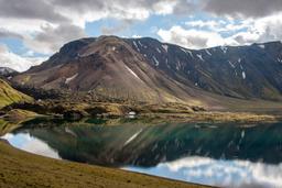
Frostastadavatn ★ ★ ★ ★

Frostastaðavatn Lake
Frostastaðavatn Lake is near the Landmannalaugar car park. You can't miss the ancient lava flow coming from the Suðurnámur mountain that funnels into the lake. In fact, there are no less than three lava flows that surround the lake: Frostastaðahraun to the east, Námshraun and Norðurnámshraun to the south, Dómaldalshraun to the north.
Frostastaðavatn is a stunning panoramic destination. Beyond the lava flows, the beautiful Suðurnámur mountain rises 920 meters in the background and when conditions are right you can catch its rhyolite peaks are reflected on the lake surface. Learn more about Frostastaðavatn.
-
Veidivotn ★ ★ ★ ★

News: Anna Veselova @shutterstock
Located northeast of the Fjallabak Nature Reserve, the Veiðivötn region is a patchwork of 50 magnificent lakes that glimmer like an oasis in the middle of the black sand desert.
The 50 lakes of Veiðivötn are located in a valley, created quite recently in geological terms, in 1477 with the eruption of the Bárðarbunga volcano. The multiple craters became maars over time. A maar is a crater in which water pooled to form a lake, a common sight in Iceland. More information on Veidivotn.
-
Sigöldugljúfur ★ ★ ★ ★

Sigöldugljúfur Canyon - Takepicsforfun @dreamstime
This unpronounceable canyon, the Sigöldugljúfur, was discovered only recently. It is not marked on most maps but you can find it near Lake Krókslón (see map above).
This magnificent oasis will make for some popular Instagram photos, with waterfalls that flow into a canyon, pooling to form absolutely sublime turquoise water. Learn more about Sigölduglúfur.