The Landmannalaugar-Thórsmörk Trek
The trek from Landmannalaugar to Thórsmörk, also known as the Laugavegur or Laugavegurinn, literally the “Hot Springs Route”, is probably the most renowned in Iceland.
To give you a sense of the difficulty, this 55 km trek is also the top annual Ultramarathon trail for Icelanders, which usually takes place in July.
So what makes all the staes between Landmannalaugar and Thórsmörk so special? Quite simply that the landscapes found there are unique and truly among the most beautiful places on the planet.
- Laugavegur: an unforgettable trek
- The direction of the trek
- The stages of the trek
- Extend the trek to Skogafoss
Laugavegur: An unforgettable trek in a magnificent region
If you could only do one trek in Iceland, it would definitely be the Laugavegur that leads from Landmannalaugar to Thórsmörk. And for good reason...
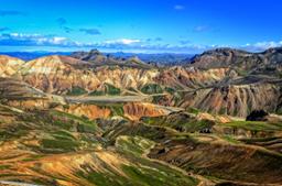
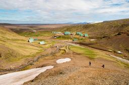
First, the Landmannalaugar region is a remote and untouched geothermal area in the southern highlands of Iceland in the Fjallabak Nature Reserve. This fire and ice working its magic without human intervention creates incredible chromatic contrasts: every shade of green and black mountain rock, the yellow tones of sulfur, the orange, pink and bluish hues of rhyolite, all framed by the ubiquitous jet black of the lava flows.
At the foot of the Landmannalaugar car park there are fumaroles and even a hot water river to warm up for the journey. The hike traverses these hostile volcanic landscapes until you reach the Thórsmörk region with its lush valleys, canyons, streams and birch forests.
The direction of the Landmannalaugar Thorsmork trek

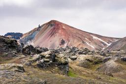
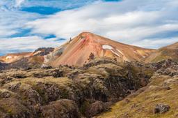
Landmannalaugar mountains
Most hikers prefer to start with Landmannalaugar and end in Thórsmörk because it is the “easiest” direction, the elevation more favorable.
However, those who flipped the trail starting with Thórsmörk were delighted to end up in Landmannalaugar to bask in the hot springs at the Landmannalaugar campsite after 4 days of long trekking. That's a great motivator.
And there is a certain poetry in starting from Thórsmörk as the beauty of these ecosystems, at first familiar, lush and bucolic, rises in dramatic crescendo with at its peak the lunar landscape of Landmannalaugar and in particular the vivid colors of Brennisteinsalda or Bláhnúkur...
The stages of the trek

The start of the hike from Landmannalaugar
Landmannalaugar - Hrafntinnusker
The hike starts with the ascent along the superb lava field of Laugahraun near the Landmannalaugar campsite and its hot springs. Then you have to push on around Brennisteinsalda with its pink flanks and incredible contrasts.
Then comes the geothermal zone of Storihver and its hot springs with fumaroles everywhere. A few kilometers later, you will have to cross an obsidian field to finally reach Hrafntinnusker.
Visibility is often poor here due to fog, which is why pegs line the end of this section fo trail to keep you on track. This stage involves a total of 12 km and no less than 470 m of positive altitude difference, we are then at an altitude of about 1100 m. The stage takes approximately 4 to 5 hours.
Hrafntinnusker - Álftavatn
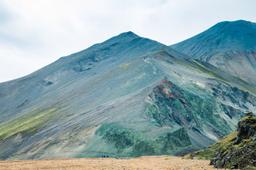
For many hikers, this is the most beautiful stage of the trek. After crossing a long sandy and snowy plateau, you cross several snow bridges. The rocks with their red and black tones display striking contrasts.
After walking along a river for a few kilometers, you reach an unforgettable viewpoint overlooking the lush valley of Lake Álftavatn and its borderland of glaciers. To reach the lake, you need to cross an impressive ford that stretches 3 or 4 meters wide. Again, the stage represents 12 km for 4 to 5 hours of walking.
Alftavatn — Emstrur (Botnar)
You'll have to cross two new fords before arriving at the Hvangil farm. This marks your entrance onto the Hvannagilshraun lava field, after which you cross yet another ford beyond which lies a vast sandy plain.
This takes you up to the Innri-Emstruá river and its impressive waterfall before entering the Mælifellsandur plain. A few kilometers further on, we reach Emstrur around the 15 km mark of this stage, which is usually done in 6-7 hours.
Emstrur (Botnar) - Thorsmörk
After crossing the bridge that overlooks the Fremri-Emstruá River, the hike takes you along the Markarfljót. The landscape changes to lush valleys that lead to a new ford-crossing, a big one this time. Surprisingly for Iceland, this stage cuts through a small forest (with rare local birch trees towering around you) before arriving in the glacial valley of Þórsmörk. (15 km, 6-7 hours)
Extend the trek to Skogafoss by one or two days
For the bravest among you, it's possible to extend the trek by one or two days with a stage to Skogafoss from the Basar refuge (Thórsmörk), which is a trek in its own right better known as the Fimmvorduhàls trek. While the trail was disrupted by the Eyjafjallajökull eruption in 2010, this portion of the trek is a great final stage to the whole experience. All the details about the Fimmvörðuháls trek.
Thórsmörk - Fimmvorduhàls
The Fimmvorduhàls pass is as the name suggests in the mountains, specifically at an altitude of 1100 m, and the trek involves a good kilometer at this altitude. Slipping between the Eyjafjallajökull and Mýrdalsjökull glaciers takes you to “Goðaland”, the land of the gods where everything is on a divinely massive scale.
This area was devastated by the famous eruption of 2010, and the landscape carries the scars. It will take another 5–6 hours to cover the 12-14 km of this stage with an elevation of 900 m to scale the Fimmvörðuháls pass.
Fimmvorduhàls - Skogafoss
The last 13 kilometers of the trek are all blissfully downhill, a descent of -900 m elevation to reach Skogar that nevertheless takes 5-6 hours of walking before you find yourself at the top of the famous Skogafoss waterfall.
While you can complete this trek independently, you can choose to book with a guide, including overnight stays in a refuge:
Also worth reading:
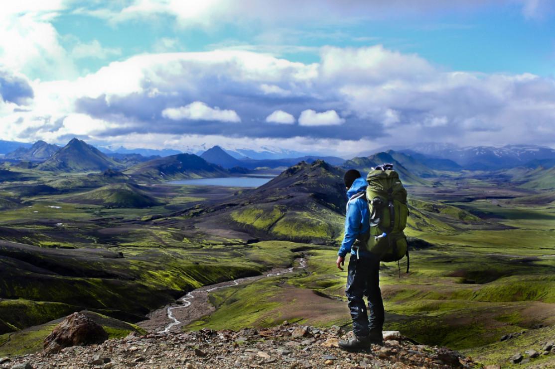
Photo crédit Hiker at Fimmvorduhàls: ©Jens Ottoson - Fotolia.com