The Fimmvörðuháls Trek
Fimmvörðuháls, literally the "Five Cairns Pass", is the stuff of legend in southern Iceland.
This incredible trek, named after the landscape it crosses, takes you from Skógar to the Thórsmörk Valley through the famed Fimmvörðuháls ice pass. This is without a doubt one of the most beautiful hikes in Iceland, but also one of the longest and most demanding. This trail also serves as an optional extension to the Laugavegur trek that we detailed in a previous article.
The Laugavegur trail from Landmannalaugar to Thórsmörk is already quite the achievement, but many hikers can't seem to get enough of this rugged wilderness and decide to keep going to Skógar:
The Fimmvörðuháls trek takes you through stunning landscapes beginning with the beautiful Skógafoss waterfall, then through green meadows and jet black lava fields, over craters, across snowfields, and finally into the lush Thórsmörk valley with its mythical canyons.
- The Fimmvörðuháls Pass
- Hiking North or South?
- How long does the hike take?
- How to get back to the starting point?
- Trekking with a guide
- The Fimmvörðuháls trek step by step
The Fimmvörðuháls Pass

Cutting right between two colossal glaciers in southern Iceland, namely Eyjafjallajökull and Mýrdalsjökull, the Fimmvorduhals is a mountain pass about 1,032 meters above sea level.
It separates three valleys: the Hrunar and Hvanná valleys in the north and Skógá in the south. Fimmvörðuháls is also infamous for being the site of the first eruptive phase of Eyjafjallajökull (Eyjafjoll) between March 20 and April 12, 2010.
As a result of these events, the Fimmvörðuháls area has changed a lot since 2010. Two new additions to the landscape appeared, two large volcanic cones known as Móði and Magni, named after Thor's two sons, and there is now a lava flow which you can see up close via the Goðahraun trail.
The Fimmvörðuháls hiking trail is a rare opportunity to wander between two glaciers, get up close and personal with a volcano, and admire no less than 26 waterfalls... It's a great package deal.
Hiking north or south?

From the Þórsmörk region you can indeed hike south to Skógar via the Fimmvörðuháls trail, but most hikers prefer to do it the other way around: hiking north from Skógar to Þórsmörk.
The ascent from Skógar is a bit less demanding, with a steady but manageable elevation. Walking past the many Skógá Valley waterfalls makes for a great way to start the day, while the last leg into the Thórsmörk valley is the perfect closer...
The other argument for this direction is that you can keep going after arriving in Thórsmörk, as there are countless trails to choose from for those who want to extend the adventure.
How long does the hike take?

Foto ©jackyg95 @fotolia
The trek is 25 km in total with an elevation exceeding 1,000 meters, starting from sea level in Skógar up to the 1,032 meter altitude of the Fimmvörðuháls pass. Suffice to say that this will be a test of strength with some technical challenges thrown in there for good measure in the snowy areas.
The total hiking time will be 7.5 to 11 hours depending on your pace, the weather conditions, and how many photos you stop to take.
There are two ways you can do this:
- Hard mode: Complete the 25 km trek in one day, but if you want to make it back before nightfall (obviously you do) you should leave early in the morning to make sure you have enough time.
- Easy mode: Do half and stay overnight at the Baldvinsskáli or Fimmvörðuhálsskáli shelters, located near the half-way point and quite close to each other, which is the perfect way to recharge your batteries before starting the descent, which is easier, on day 2.
The 2-day hike can be broken down approximately as indicated below:
- Skógar - Fimmvörðuhálsskáli (14 km - about 5 hours)
- Fimmvörðuhálsskáli - Básar (12 km - about 4 hours)
The time it takes will obviously depend on the direction you choose: the Básar - Fimmvörðuhálsskáli direction is quite steep when going uphill.
How to get back

Unlike many hiking trails in the country, the Fimmvörðuháls trek is not a loop but an A to B trail. Once you arrive in Thórsmörk, you have to consider how to get back to the starting point if your car is there. So there are a few options.
While some intrepid hikers return on foot the next day after a night at the Básar refuge in Thórsmörk, the vast majority opt for a return bus from Thórsmörk to Skogar. You'll need to carefully estimate your estimated time of arrival as buses are not very frequent and while some stop at Skogar, those aren't the most frequent.
The more frequent buses go directly to Seljalandsfoss or Reykjavík. So if you end up on one of these, you'll need to take another bus to the starting point in Skogar if your vehicle is parked near the waterfall.
Another option is to park in Reykjavik and take a bus to Skogar, for example, because it's easier to find a return bus back to the capital directly.
Bus routes change from year to year, so be sure to check the relevant websites for up-to-date information.
Trekking with a guide
If all this sounds like too much of a hassle, the alternative is to trust a professional and book a day-tour of the Fimmvörðuháls trek or part of it with a tour guide.
This means you can delegate the return trip logistics, which is convenient, but this also remains the safest option if you aren't confident hiking alone, as these guides know the region very well.
With this option, the guide will take you back to the starting point:
The Fimmvörðuháls trek step by step

The trek is only possible in summer, from late June through to the end of August, when the weather is on your side. Even so this 25 km challenge requires careful preparation, including checking local weather via vedur.is because it can turn on you very quickly. And with an altitude of 1,032 meters, it's not called an ice pass for nothing, so expect temperatures to drop below 5° even in summer.
Dress well for the cold with proper thermal layers and keep that weather website refreshed because hiking through thick fog near Fimmvörðuskáli can actually be dangerous.
We strongly recommend sturdy hiking boots, a good GPS, warm clothing even if the day seems sunny, and plenty of water! Walking batons can be useful as well as crampons when hiking through the snow in particular.
This trek is known to be quite difficult, and as mentioned you can complete the 25 km in 8 to 11 hours depending on your pace and the weather conditions. The trail is very well-marked with yellow pegs, and generally hikers finish in about 8 to 9 hours total.
There are 3 clearly-defined steps to this trek:
- Part 1/3: From Skógáfoss and its 26 waterfalls to the Fimmvörðuháls mountain refuge
- Part 2/3: The Fimmvörðuháls ice pass between the Eyjafjallajökull and Mýrdalsjökull glaciers
- Part 3/3: Arriving in Thórsmörk, AKA Goðaland, "the Valley of the Gods"
Part 1/3: Skógáfoss and the trail of waterfalls

This hike departs from the Skógáfoss car park. Your first step will be a fairly steep staircase to the right of the waterfall to reach the top, which is where hike really begins.
Follow the trail along the beautiful Skógá River with its seemingly endless string of waterfalls: tall and tumbling waterfalls, multi-level cascades, hidden falls, angry and stormy falls, sunset falls among the flowers and under scenic bridges... In total 22 to 26 of them depending on your trail, and at any time looking back over your shoulder for a spectacular view of the Atlantic Ocean.
The landscape around these natural wonders can be as stunning as the falls themselves, often framed in lush meadows. The elevation is steady for almost 2.5 hours of walking or 7.5 km until you reach a bridge or rather a footbridge across the river.
At this point you are about a third of the way there, already at an altitude of 617 meters, and almost at the first shelter named Baldvinsskáli.
Part 2/3: The Fimmvörðuháls ice pass between the two glaciers

Foto ©kojin_nikon @fotolia
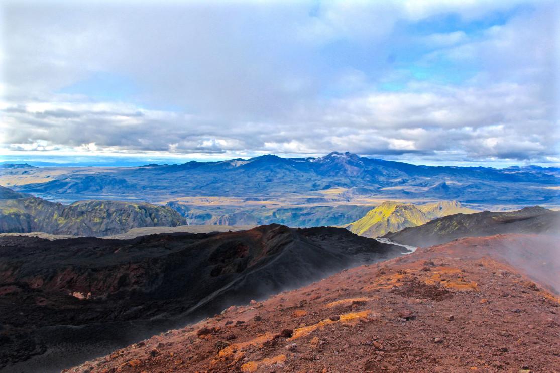
The second section after the refuge is a whole other landscape, almost another planet entirely, marked by volcanic rock and moss patches. This is where you usually have to cross the first snowfields, which sometimes extend over several hundred meters. This really makes the climb extra difficult, so pace yourself.
The Fimmvörðuháls pass is where you'll find the second refuge. This is the mid-point of the trek, but also the end of the climb, as this is the highest point of the trek at 1,019 meters. Although to be specific this is no longer the high-point, as in 2010 that title was claimed by Móði, one of the two craters (the other is Magni) in the Goðahraun lava field. The twin craters were formed during the eruption of Eyjafjöll (Eyjafjallajökull) and stand at 1,032 meters above sea level.
The heat from past eruptions keeps the ground warm here, and the snow cover never stays long. The red and black flanks of Magni and Móði are typical of volcanic cones, and if you have the legs for it we recommend climbing those final 13 meters of elevation to the top of Móði to look down into the crater!

Picture © heibergerwork @fotolia
Part 3/3: The descent into Goðaland and finally Thórsmörk
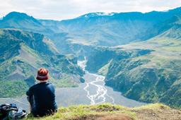
At this point, you'll have approximately 7.5 kilometers of trail ahead of you. The descent becomes quite steep, and even very steep near the Heljakambur pass where you'll need to climb down secured by a rope.
The trail continues down to the Morinsheiði Plateau, with absolutely fantastic views of the majestic Katla volcano, then further down along the Kattarhyggir ridge.
Then you have two choices:
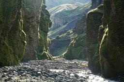
- Descend into the Hvannárgil Canyon
- Go directly to the Básar refuge
The first option takes you into the valley and the Hvannárgil canyon through a magnificent birch forest. But if you're ready for option two, near the river you'll see the sign indicating the Básar refuge, which marks the end of the exhausting but unforgettable Fimmvörðuháls trek.
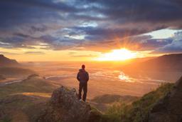
However, you choose to finish, the Fimmvörðuháls hike is truly a wonderful experience and it's not hard to see why it's among the most famous in Iceland. It's impossible not to appreciate the sheer beauty and variety of landscapes with lush valleys, glaciers, volcanoes, waterfalls, and a dramatic canyon at the end.
Just keep in mind this is a high-difficulty trail reserved for experienced hikers. If you lack the experience, you'll need at least a sense of adventure and the endurance to walk up and down a mountain over a day or two.

Photo ©Martin M303@fotolia