The Eyjafjallajökull Glacier and Volcano
Eyjafjallajökull is an ice cap in southern Iceland and arguably the most famous, or rather infamous, despite being only the sixth-largest on the island.
Eyjafjallajökull rose to the heights of fame not for its ice, but rather for its fire: the volcanic system named Eyjafjöll that rests under all that frozen water. Ad many remember, the 2010 eruption of this system paralyzed the airspace of a large part of Europe for several days.
- Eyjafjallajökull: pronunciation 101
- The Eyjafjallajökull glacier
- The Eyjafjöll volcano
- The 2010 eruption
- How to get there
- Activities near Eyjafjallajökull
Eyjafjallajökull: pronunciation 101
Eyjafjallajökull was a devastating tragedy, but a small silver lining was the comedy of watching journalists from all over the world trying to say its name when discussing the eruption. Many Icelanders saw the comedy in all of this and appreciated the attention given to their peculiar language, and there are scores of videos by locals poking a bit of fun at foreigners trying to pronounce the volcano's name (video).
Here's an easy phonetic transcription: ei-ya-fia-tla-yeu-koutl. Eyjafjallajökull literally means “The glacier on the mountains near the islands”, as you can see in the translation below:
- Eyja: islands
- Fjalla: mountains
- Jökull: glacier
The islands referenced in the name are the beautiful Westman Islands which form an archipelago a little further south, and on a clear day you can see them from the top of Eyjafjallajökull.
The Eyjafjallajökull glacier

Eyjafjallajökull glacier
Eyjafjallajökull is therefore not a mountain, or even a volcano, but a glacier. One of the large glaciers in southern Iceland with an area of 78 km², located west of Myrdalsjökull and north of the small town of Skogar. Its highest point, Hámundur, is 1650 meters above sea level and at its summit there is a caldera almost 3 kilometers in diameter.
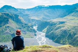
North of the glacier, Eyjafjallajökull has two major glacial tongues, Gýgjökull and Steinholtsjökull, that creep downhill to meet the Markarfljót River in the Thórsmörk Valley.
The ice cap covers virtually the entire Eyjafjoll volcanic system.
The Eyjafjöll volcano

The Eyjafjallajökull eruption of 2010
Eyjafjöll is a volcanic system: a grouping of several volcanoes connected underground, the main one being a stratovolcano. This is what's known as a red volcano, that is to say eruptive or effusive.
Historically, the Eyjafjöll eruptions resulted in significant effusions of slag and ash, fumes, and lava flows. Bad news for everyone nearby.
This stratovolcano is estimated to be 700,000 years old, and it's not a particularly violent volcano, nor is it particularly active. Its track record shows it rarely awakens, with eruptions dated 550, 1612, 1821 and March 2010.
Icelanders are not too worried about this one compared to some of its neighbours, such as Katla, which has a history of much more destructive eruptions. Katla and Eyjafjöll are also theorized to be linked volcanic systems. The data suggest so, as when one of the two volcanoes erupted in the past, the other followed, as was the case during the eruptions in 1821 and 1823 for example.
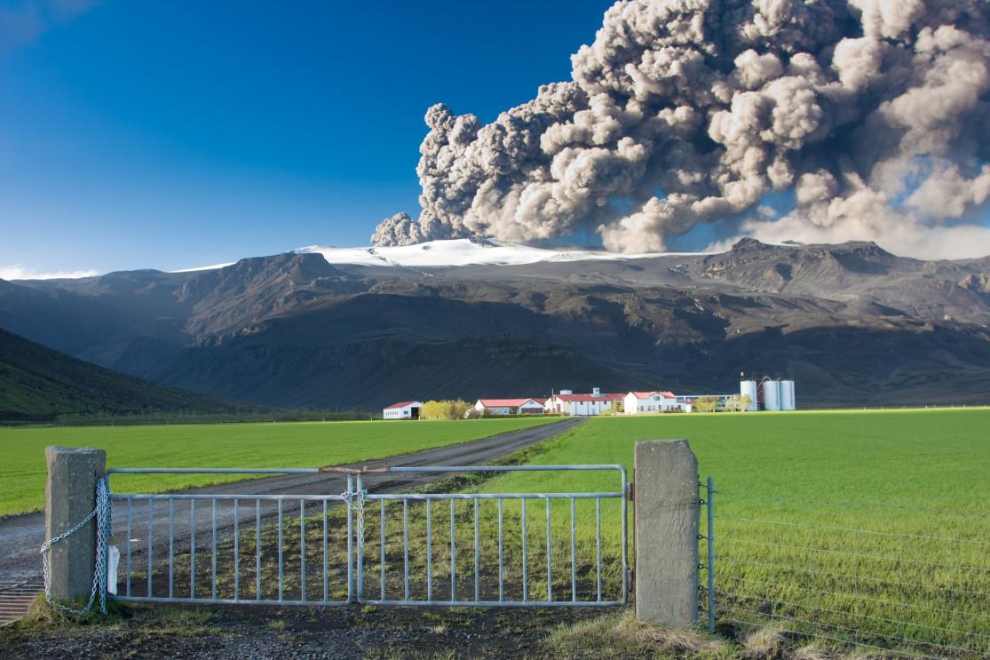
The 2010 eruption

The eruption of Eyjafjallajökull in 2010 seen from the Thorvaldseyri farm - Johann Helgason @dreamstime
The 2010 eruption began on March 20th on the Fimmvörðuháls Pass and ended seven months later, on October 27th. This eruption was given a score of 4/8 (cataclysm) on the Volcanic Explosivity Index.
The eruption had two phases:
Phase 1: lava fountains
After about 180 years of sleep, the Eyjafjöll began to grumble with significant seismic activity. Days later, just before midnight on March 20th, 2010, Eyjafjöll woke up fully and began ejecting molten lava, and then stopped. An eruptive fissure opened, measuring 300 to 500 meters.
On March 31st, a second fissure split the land and generated lava flows continuously until April 12th.
Phase 2: Smoke Plumes and Floods
On April 14th, after a 2-day interruption, the lava returned with a vengeance. This melted many metric tons of ice, which in turn caused major floods, or jökulhlaups. The Gýgjökull glacier tongue became flooded further north, and almost the entire population of 800 living in the region had to be evacuated under a state of emergency. This continued until June.
The melting of the ice cap changed the landscape, which created depressions into which the meltwater flowed. Immense clouds of smoke and steam rose into the skies, and it was these volcanic plumes of water vapor, volcanic gases, and ash that disrupted global air traffic for a week. The winds drove much of this particular matter over Europe. And that's how all those planes found themselves grounded.
The plume rose up to 9 kilometers in altitude, with a total volume of over 250 million cubic meters, and over the years these ash deposits have been found all over Northern Europe.
The eruption began to slow down after April 21st, but did not stop completely until October 27.
The consequences of the eruption
Remarkably, there were no injuries or deaths caused directly by the event. Respiratory problems were diagnosed in some people who were too exposed to ash clouds. However, the financial losses for the aviation sector were estimated at over 2 billion euros.
Also, significant were the environmental consequences, with much of the south coast covered in volcanic ash, which had disastrous consequences for harvests, while the floods destroyed numerous homes and some key infrastructure.
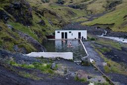
How to get there

Eyjafjallajökull is in southern Iceland, between the Thórsmörk Valley to the north and Skógar and its Skógafoss Falls in the south.
It's very close to Road number 1, in fact you can see the glacier from the car while driving there when you get between Seljalandsfoss and Skógar. The best spot to frame a whole shot of the whole glacier is probably the Thorvaldseyri farm just before Skógar (see photo of the eruption). This place has a great view of the volcano and the glacier.
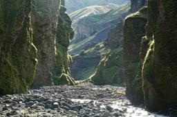
For those who want to get closer, the Fimmvörðuháls trek, one of the most beautiful treks in Iceland, leads to the exact spot where the eruption started. The scene of the crime, so to speak.
If you don't have the chops for a trek, but still want to see it up close, you can book a super jeep day trip:
Activities near Eyjafjallajokull

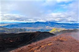
Fimmvörðuháls is the area devastated by the first eruptive phase of Eyjafjallajökull (Eyjafjoll) between March 20th and April 12th, 2010.
As you can imagine, the landscape near Fimmvörðuháls has changed a lot since 2010. In fact, the eruption created two large volcanic cones: Móði and Magni, named after Thor's two sons, and a cooled lava flow which is right in the path of the Goðahraun trek.
The heat of past eruptions remains in the very bedrock here, and the snow never stays on the ground very long. The red and black flanks of Magni and Móði are typical of volcanic cones. You really should hike out to visit the two craters and even climb to the top of Móði!
In addition to the Fimmvörðuháls trek, a unique opportunity to see an eruption crater that changed the world, don't miss out on the Eyjafjallajökull Erupts Visitor Center.
This small museum retraces the history of the 2010 eruption and its consequences in detail. There is some exceptional media, photos and videos, which can be very moving. It's located just opposite the famous Thorvaldseyri farm along road number 1 heading east, just before Skogar.