The Valahnúkur Hiking Trail
Mount Valahnúkur is a 458-meter tall promontory hidden in the fantastic Thórsmörk Valley in southern Iceland.
Valahnúkur is impressive in itself, but people come here for the legendary hiking trail winding up its flanks. The 360° panoramic view at its summit is among the most beautiful panoramas that can be found in Iceland.
- When to go and how to get there
- Thórsmörk hiking trails that lead to the summit of Valahnúkur
- The panoramic view from Valahnukur
When to go and how to get there
To reach Valahnúkur you'll need to get yourself to the Thórsmörk valley. The best time to visit this highland paradise is summer, ideally between July and August.
There are 3 ways to get to Thórsmörk:
- In a 4x4
- In a local bus
- With an organized tour
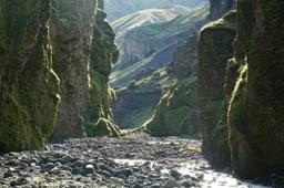
Driving from Seljalandsfoss, take the F249. This trail is smooth at first but becomes quite technical when you get near the Markarfljót's waters. There are indeed deep fords to cross on the F249.
If you're going there in a rental 4x4, you need to be quite a capable off-road driver. A rental SUV won't be enough as you'll have to cross several fords, including the one at La Krossa, considered one of the most difficult in Iceland. Without a raised and prepared 4x4 you're basically playing with fire.
Taking a local bus is probably the simplest and safest solution. The bus from Reykjavík to Thorsmörk runs daily from June 10th to September 15th. It makes several stops at Hveragerði, Hella, Selfoss, and Hvolsvöllur before finally reaching the Seljalandsfoss waterfall car park.
Several companies have bus lines to this region, such as Volcan Huts or Reykjavik Excursions. Most tourists stay on site for a day, but you can also camp out there in tents or rent little huts.

There are several bus stops in Thórsmörk:
- Husadalur
- Langidalur
- Básar
To reach Valahnúkur, you'll need to stop at either Husadalur or Langidalur.
And if you want a package deal, there are full day tours available:
- Full day hike to Thórsmörk via Super Jeep from Hvolsvöllur
- Full day hike to Thórsmörk via Super Jeep from Reykjavík
Thórsmörk hiking trails that lead to the summit of Valahnúkur

The Thórsmörk hikes
Depending on where you arrive in Thórsmörk, there are different hiking trails to Valahnúkur. Most hikers choose either Langidalur or Húsadalur as the starting point.
Húsadalur is often preferred as the main hikes in the valley leave from there. We also strongly recommend that you buy a local hiking map of Thórsmörk at the information point in Húsadalur.
There are a number of paths to climb to the top of Valahnúkur, as can be seen on the map above:
- From Langidalur, hike directly to the summit (2.2 km A/R)
- From Husadalur, hike directly to the summit (2.4 km A/R)
- Complete the official “Thórsmörk Panorama” loop (blue on the map) (4.2 km)
- Combine the “Thórsmörk Panorama” loop (blue on the map) and the Merkurrani loop (green)
- Combine the “Thórsmörk Panorama” loop (blue on the map) and the “Thórsmörk Highlights” loop (red)
All roads lead to the top of Valahnúkur! And this makes sense as this is the most renowned viewpoint in the region.
Many visitors opt for the “Thórsmörk Panorama” blue loop, which showcases the region's main landscapes and has the advantage of being short enough to combine with another trail if you're doing a full day trip.
The Thórsmörk Panorama hike

The perfectly equipped Valahnúkur hike
Conveniently, the Thórsmörk Panorama hike can start from either Langidalur or Husadalur. This trail has relatively low elevation (about 300 meters) and you can wrap up the 4.2 km loop in less than two hours.
Starting from the Húsadalur campsite, near the hut, a small path leads east into a charming birch forest. The slope is easygoing and there are even small wooden logs making a walkway in the middle of the groves.

On the way, the view to the north and east towards the beautiful Tindfjöll mountains will certainly draw your gaze.
After about 2 km and 30 minutes of easy walking, you'll reach the Langidalur hut, visible from afar with its Icelandic flag flying above. This is in fact the foot of the Valahnúkur summit, and already the view of the valley is simply incredible.

Langidalur
From here, a sign indicates the way to the summit. It is only 1 km away, but 30 minutes are still necessary to get to the top of Valahnúkur mountain.
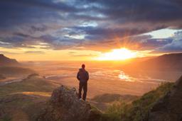
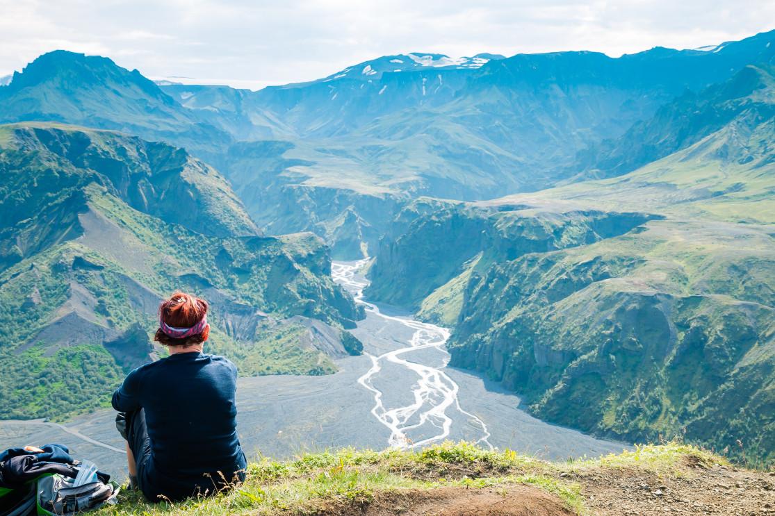
The view from the top of Valahnukur

Panorama of Valahnukur
When you reach the summit, take a moment to look around you and really take in the absolutely unique 360° panorama. In clear weather, the view in all directions goes on for miles, and there is even an orientation table so you can pinpoint the different landmarks.
To the south, the Krossa cuts through the Thórsmörk Valley at the foot of the Eyjafjallajökull volcano, with the majestic Mýrdalsjökull dominating the horizon to the south and east.
To the west lies the lush Merkurrani Plateau, and to the north the meanders of the Markafljót, with the superb Tindfjöll on the north-western horizon.
Visitors often stop to enjoy a picnic at the summit to enjoy this incredible view while breaking bread together.

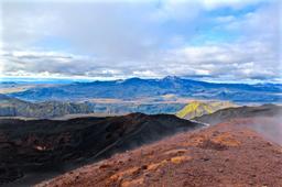
View from the summit of Valahnúkur towards the Merkurrani Plateau
The trail continues north in the direction of Húsadalur, a path that commands a view of the Merkurrani Plateau, and many hikers branch off to extend the hike with this second trail. But if you're ok with one loop, from the summit all that's left is 1 kilometer to reach the campsite.
On the way you'll see the famous Sönghellir, the "singing cave", a vast cavity surrounded by bright green moss. You'll have to climb a few rocks to reach it, but it's worth it just for the acoustic experience.
Arriving in Húsadalur, the trail takes you past a superb little hot spring near a charming hut in the shape of a wooden barrel. The small hot spring is pretty to look at, but the real treat is to soak your feet in these healing waters after a good day of hiking.