Maelifell: the Mælifellssandur volcano
The Mælifell mountain north of the huge Mýrdalsjökull is one of the most photogenic in Iceland.
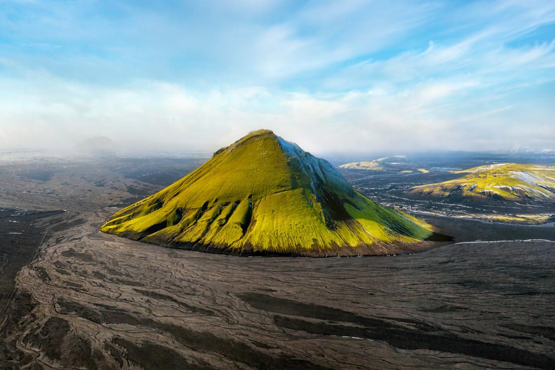
This place is completely surreal, a mountain shaped like a pyramid with flanks carpeted in green moss that contrast in spectacular fashion with the black desert of Mælifellssandur at its feet.
The small peak of Mælifell is a true emblem of the region and has become a favorite spot for photographers in recent years, despite quite difficult access along the F210 track.
The origins of Mælifell

Maelifell was formed about 10,000 years ago during the last ice age, when eruptions rising from beneath caused the Mýrdalsjökull ice sheet to retreat.
Mælifell is 200-meter-tall volcano that dominates the black sand plains of Mælifellssandur, contrasted by the Myrdalsjökull ice and its Katla volcano in the background.
This composite cone AKA stratovolcano was named Maelifell, which means “measuring hill”, by the first inhabitants of the island. This was a common name given to nine other peaks in Iceland to use as early navigation points.
Mælifell and the Mælifellssandur

The clay soils of Mælifellssandur
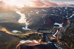
Mælifellssandur is a completely uninhabited desert that lies between the Mýrdalsjökull and Torfajökull glaciers. There is almost no vegetation, just black ash cut by the numerous meandering rivers that crisscross the region.
Approaching Mælifell, the desert soil becomes turns to patches of clay along the F210 off-road trail, Fjallabaksleið syðri, the only one that crosses this desolate landscape and one of the most beautiful in the whole country.
The green pyramid of Mælifell stands proudly on the edge of the F210 rising to an altitude of just under 800 meters.
The region rose to fame as the setting in a string of movies and TV shows such as Game Of Thrones for example.
What to do near Mælifell

Mælifell seen from Rauðibotn
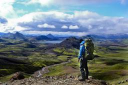
While tourists try to climb Mælifell (1 hour round trip), there are no official hiking trails to climb it and the ascent is often very slippery. But the view from above, when you turn towards Mýrdalsjökull and the black sands of Mælifellssandur, is simply breathtaking.
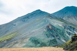
The vast majority of tourists simply take a quick picture as they walk around the volcano, up close to capture the colors of the soil near the pyramid. The contrasts in good weather are striking, and it's a great walk in Mælifellssandur staring up at the fantastical green cone.
Mælifell deserves to be shot from any angle, but of you want the best shot you need distance to fully capture it with a wide-angle lens. Another tactic is to photograph the site from a high vantage point on one of the nearby peaks. Mount Strútur in the north and especially the Hólmsárlón plateau, near Rauðibotn, are excellent viewpoints. The trail to Strútur is just behind the Mælifell along the F210.
How to get to Mælifell
Getting to Mælifell is not easy by any means but there are several routes to the summit, some easier than others. You will absolutely need a 4x4 vehicle to reach it however, and don't even think about going there in winter, the trail is closed just after summer and the F210 is one of the last trails to opens, usually in early July.
There are 4 roads to Mælifell, only one of which is really easy:
- The F210 from the West
- The F261
- The F210 and F233 from the East
- The F232
The F210 from the west

This road is not user-friendly, only off-road 4x4 vehicles can make it. The F210 from the West has the reputation of being the most picturesque, at the cost of being the most technical and slowest! The scenery of Fjallabak is definitely worth a visit, but if you choose this road the F210 has some surprises in store for you after the intersection with the F264.
You have to cross a good fifteen fords, two of which are a real challenge. The first is Ljósá, with several inlets to cross and a water depth that can exceed 60 cm. The second is Bratþálskvísl, approaching the intersection with the F261. The height of the water is similar to that of Ljósá but the current is even stronger.
This portion of the road is not passable for SUV-type rental vehicles, as you need the kind of ground clearance only afforded by prepared off-road vehicles.
The F261

Another trail reserved for large 4x4 vehicles, this one is not particularly interesting compared to the F210. The F261 track runs along the Markarfljót and you'll have to cross the famous Bratþálskvísl ford, which is known to be difficult.
The F210 and F233 from the East

A little more user-friendly, this route is one of the two accessible to rental 4x4 vehicles, but be aware the Hólmsá can become impassable on bad weather days. From the east, whether via the F233 or the F210, the trails easy to navigate. The only hard part is at the end, very close to Rauðibotn, with a very wide ford crossing (the Hólmsá crossing) which can be tricky as it's sometimes 50 cm deep.
The F232

Maelifell - Lukas Bischoff @Dreamstime
The drive via the F232 is the easiest, the quickest (1H30), and is accessible to rental SUVs. There are a few small fords to cross, but none exceed 30 cm and since this route passes west of the famous Hólmsá ford you can avoid being swept away downstream. This is probably the best route to take unless you're fully prepared for technical off-road driving.
Whatever the route you choose, when you arrive a few kilometers from Mælifell, the F210 trail becomes a dead flat ribbon of black ash, undoubtedly one of the most enjoyable drives in Iceland.
But all beauty hides danger out here, and in the late afternoon on rainy days the streams can overflow and make the road a bit of a muddy swamp.