The Bláhnúkur Hiking Trail
Bláhnúkur is a mountain in the Landmannalaugar region and its ascent is a short hike known to be one of the best in Iceland.
Landmannalaugar is a hiker's paradise, but if you could only choose one hike to do in the region, it would definitely be Bláhnúkur.
When to go and how to get there

To hike in Bláhnúkur you'll have to go off the beaten track and into the Highlands, to Landmannalaugar. Travel tips and itineraries for Landmannalaugar can be found in our dedicated Landmannalaugar guide.
Although isolated, the region is not the hardest place to get to but you will absolutely need a 4x4 or SUV vehicle to get there. The easiest way to reach Landmannalaugar is via the 208 from the north.
The road is closed in winter and only accessible between June and September. In winter, the only way to get there is group excursions with tour companies who drive you there in prepared off-road vehicles:
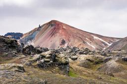
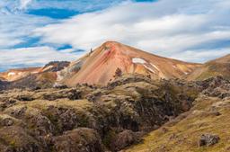
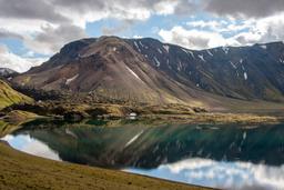
Bláhnúkur Mountain

The beautiful Bláhnúkur mountain, the “Blue Peak”
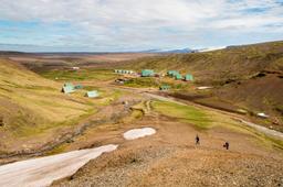
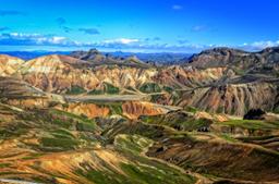
Landmannalaugar is famous for these fantastical colored mountains, an absolutely unique sight you wonet soon forget. In fact, Bláhnúkur is the first thing you notice when you arrive at the Landmannalaugar car park.
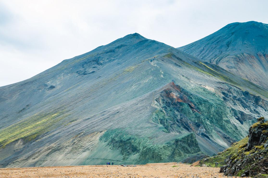
Obviously the fact of its height, dominating the nearby mountains at an altitude of 943 meters, draws the eye. But that's not the main thing about it... Bláhnúkur AKA the “Blue Peak” is decked out in vivid shades of blue and green.
This volcano formed during the ice age and is part of the large volcanic system of Torfajökull. The colours are due to its rock and soil composition, as mentioned of volcanic origin, with resinite (rhyolite rock) which occurs after subglacial eruptions.
Bláhnúkur is, with Brennisteinsalda, its neighbor (the red volcano), a local legend in Landmannalaugar.
The Bláhnúkur hiking trail

The hike to Bláhnúkur is not easy and will require a fairly athletic physical condition. Whatever the direction of the hike, the climbs are steep and sometimes slippery.
The direction of the hike

Landmannalaugar evening light - Joshua Sortino @Unsplash
From the Landmannalaugar car park you start hiking south with the Barmur Range on your left and its superb ocher colors to set the tone right off the bat.
Approximately 700 meters down the trail, you'll reach a fork where you have to choose the direction of the hike. As seen on the map earlier, this hiking trail is a loop and you can go either:
- West through the Grænagil Canyon
- East by climbing Bláhnúkur directly
The west path is recommended if you prefer an easier ascent. If conditions are rough some sections become slippery so in that case it's best to attack the ascent on the west side via Brennisteinsalda.
However, the vast majority of hikers ascend from the east so they can enjoy the descent toward Brennisteinsalda. This has a significant advantage: the hike can be extended with the Brennisteinsalda trail before returning to the car park (details at the end of the article). This is a great alternative to the official Bláhnúkur hike if you have the stamina.
A magnificent ascent

Grænagil and its very pronounced green tones
Below is a guide for the most traditional itinerary, going east.
Bláhnúkur is very well signposted from the car park so all you have to do is follow the pegs. At the foot of Grænagil you'll have to cross the river via a small wooden bridge.
Already you'll be feeling the steep inclination in your calves on the absurdly vivid green slopes of Grænagil.

Just a few hundred meters up this mountainside, when you turn back towards the car park, the view is absolutely incredible. The moss-covered lava fields of Laugahraun and the view across to Barmur is like looking at another planet.

Barmur while climbing Bláhnúkur
The ascent goes on and gets even steeper on the last kilometer before the summit. The trail then zigzags across the slopes of Bláhnúkur to facilitate the ascent. The summit is quite often foggy and the weather changes very quickly, so be prepared.

From the summit, the view on a clear day is absolutely incredible, a full 360° panorama of incredible colours. You can see no less than six glaciers on the horizon with the red mountains in the foreground, an exceptional view.
If you can, we recommend timing the visit for late afternoon during the long summer days to catch this all in the silvery light of the midnight sun (photo below).

Bláhnúkur summit panorama - Jekaterina Sahmanova @Dreamstime
Most hikers spend long minutes photographing this panorama in all directions because it's all equally impressive. The view to the north, with the beautiful Frostastaðavatn ake and Suðurnámur in the background, or looking west you can see the red mountain of Brennisteinsalda.

You then descent back to Brennisteinsalda, following the trail to the west. Definitely do not leave the trail as the other alternative paths are much too steep and can be dangerous.
The landscape is, for its part, as beautiful as ever and you can sometimes come across a few snow patches even in August. The descent is rather easy but can be slippery.

At more or less the 5 kilometer mark from the car park you'll arrive at the foot of Brennisteinsalda mountain after crossing a small stream on stone steps. Here, you have two options: complete the official Blahnukur hike through the lava fields then into the Grænagil Gorge before reaching the car park, or continue with the Brennisteinsalda loop and its famous fumaroles.
The official Blahnukur hike is a 6.5 km loop that takes approximately 2.5 hours. If you opt for the second alternative, it will take 2 more hours for a total of 9.7 kilometers.