Frostastaðavatn Lake

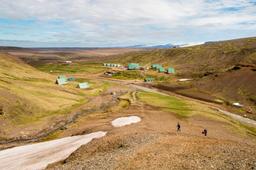
The Frostastaðavatn lake in the Landmannalaugar region is a beautiful lake, a must-see because it is located near the Landmannalaugar campsite.
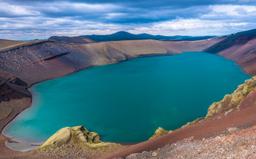
In addition to its easy access, the lake with the difficult to pronounce name Frostastaðavatn is known for its magnificent dark green color.
The Landmannalaugar region has many superb lakes like the nearby Ljotipollur, for example, or even if they are a little further away, the magnificent lakes of Langisjor or the Veiðivötn.
Located just two kilometers from the car park, Frostastaðavatn is the closest to Landmannalaugar.
How to get to Frostastaðavatn Lake?

Getting to Frostastadavatn is a piece of cake, as the lake is pretty most obvious feature of the landscape as you arrive in Landmannalaugar via Road 208. A few hundred meters after passing the exit to Ljotipollur on the left, Frostastaðavatn will come into view on the right side of the road, with parking nearby.
The lake is located exactly at the junction between the 208 (Fjallabak nyrðri) and the F225 (Landmannaleið). The 208 is closed winter to rental vehicle because these slopes are unsafe.
There is a small path that allows you to get closer to the lake.
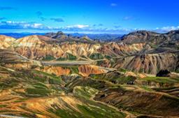
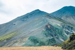
Frostastaðavatn: an incredible lake
As ever, traces of volcanic activity still leave their mark on the landscape. You can clearly see an ancient lava flow coming from the Suðurnámur mountain and flowing into the lake. In fact, there are three lava flows around the lake:
- Frostastaðahraun to the east
- Námshraun and Norðurnámshraun to the south
- Dómaldalshraun to the north
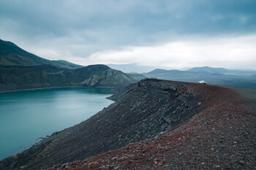
The panorama around Frostastaðavatn is stunning, out of this world. The lava flows and the beautiful Suðurnámur mountain, which rises to 920 meters, with its rhyolite peaks reflected in the peaceful lake waters when the conditions are right. Truly a sight to behold.
The lake water's minerals play with the sunlight and the color shifts from green to sometimes blue. The lake is located at an altitude of 572 meters and its surface of 2.6 km² make it one of the largest lakes in the region.
Frostastaðavatn is very well known and appreciated by Icelanders and especially by fishermen, as it is one of the richest lakes in trout, so don't be surprised to find fishermen parked around the lake.
Hikes near Frostastaðavatn

The vast majority of tourists simply go down the small path to the lakeshore, but there are some great hiking trails near the lake:
- The hike from Landmannalaugar to Frostastaðavatn
- The hike from Frostastaðavatn to Ljótipollur
The first hike is a 7.5-kilometer loop that can be done in about 1H30, an easygoing trail starting from the Landmannalaugar car park and stretching to Frostastaðavatn. The trail leaves the car park along the F224 trail before crossing the Námshraun lava field and bringing you to the lake. You can return the same way you came, but there is a short detour to the superb Stútur volcanic cone with a sublime view of the lake, so don't miss out.
The hike from Frostastaðavatn to Ljótipollur lake starts along Road 208 in the northern part of Frostastaðavatn. A small, well-marked path will take you the 1.6 kilometers to Ljótipollur before returning along the same path. The return trip takes about 45 minutes.