Ljótipollur Lake

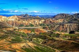
Ljótipollur lake is one of the jewels of the Landmannalaugar region. Often ignored by tourists, this site is a place of rare beauty with one of the most unfortunate names in the country...
Ljótipollur literally means “ugly mud pool” in French. The lake is located in the famed Landmannalaugar region, south-west of Veiðivötn and near Lake Frostastaðavatn, at the intersection between the superb F225 track and the 208 north.
Ljótipollur: A beautiful lake

Ljótipollur: shootdiem @fotolia
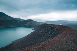
Ljótipollur is located in a maar, a volcanic explosion crater, just like Kerið in southern Iceland or Viti in the Myvatn region. This maar was created in 1477 during a colossal volcanic eruption and gradually filled with water over the years. Fishing enthusiasts should know that the lake is very popular with Icelanders for its abundance of trout.
The crater is 1.5 kilometers in diameter and the red colors of its flanks streaked with green contrast beautifully with the dark blue of the lake within. This colour pallette had made the place's reputation, and it has become one of the most photographed lakes in Iceland.
If you make it to the top of the crater, the usual tour consists in walking the crater rim all the way around to see it from all angles, which takes 45 minutes. Depending on your position, the light and the time of day, you will have to find the right angle to catch the red flanks, tinted by iron ore, reflected on the water which is the most beautiful effect.
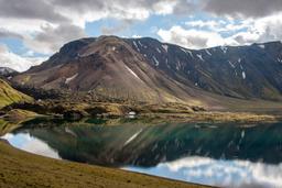
From the rim, the view of Lake Frostastaðavatn towards the Landmannalaugar campsite is absolutely magnificent. And the panorama north of the crater over Tungnaá is even more spectacular and completely unforgettable in good weather, and if you are there to see it in the light of the midnight sun there's nothing quite like it.
Taking a photo of the crater in its entirety is not really possible without a very wide angle lens, a drone, or a helicopter...
Getting to Ljotipollur
The lake is located at the junction of the F225 and the 208 and there are three ways to get there:
- Drive up the crater flanks in a 4x4
- Park at the intersection and walk up on foot
- Park at the Landmannalaugar car park for a long and beautiful hike
Go up to the crater in a 4x4
In summer, there are often a few cars parked at the intersection, but some visitors take prefer easy-mode and drive up to the crater in 4x4 vehicles. There is a car park at the top. It is a short 2-kilometer trail but very bumpy, and the climb is quite complicated and very steep over the last 200 meters.
In fact, a classic 4x4 rental SUV type that is not “elevated” would not be safe on that trail as there are large stones on the way up and some visitors end up damaging the underside of vehicles when they go up. So you have to be a very good driver with the right car, or just go there on foot!
Park at the intersection and walk up on foot

Photo credit: luis@fotolia
This is probably the preferred option for most visitors. Leave your vehicle at the intersection and take the hiking trail to the crater. The ascent to the lake takes only 30 minutes on foot and is not technical at all.
Most tourists who go up on foot also tour the rim of the crater, for a total of 7.2 kilometers to complete the loop from the intersection, around tour of the lake, and back to the car in about 1H45.
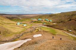
Park at the Landmannalaugar car park and hike all the way
The bravest can hike from Landmannalaugar to the crater, this represents a 16.6-kilometer loop, an altogether easygoing trail in an incredible setting with lava flows, the tephra desert, swamps, and glacial valleys before you set eyes on the crater itself.
It takes about 5 hours to complete the loop and return to the campsite if you decide to tour the rim of the crater, and the trail is marked and very easy to follow, so no risk of getting lost. This trail passes near Frostastaðavatn and the Stutur crater, which are great little pit-stops, before reaching the lake. The loop back is a bit steeper and climbs up to Norðurnamur before returning to the campsite.