Mývatn: your ultimate guide for lakeside activities
The Myvatn region is known across Iceland for its magical geological features. It is also a region where you can find a dense concentration of tourist sites in a small radius, each more interesting than the last.
Indeed, the Mývatn region is probably one of the three most visited sites in Iceland, listed as a nature reserve and protected area since 1974.
- Lake Myvatn and its region
- How to get to Myvatn?
- When to get there?
- How much time should you spend in the Myvatn region?
- The points of interest on the lake and its surroundings
- Accommodation: sleep in Myvatn
Lake Myvatn and its region
There is only one village worthy of the name around Myvatn: Reykahlið, with its 187 inhabitants, stands proud on the lake shore. You'll have to drive to Akureyri, over an hour away, to find a bigger city. But Myvatn has all the essentials: bank, gas station, groceries, and accommodations (see at the end of the article).

Located in the north-east of Iceland, Lake Mývatn has a surface area of 36.5 km², making it the fourth largest lake in the country. Its shallow waters are rich with fish species. It is home to a wide variety of birds (ducks, swans, common eiders...) and is also nicknamed “Lake of the midge” for the dense clouds of these insects that hover in summer. They don't sting, but they can be very annoying.
The Mývatn region is home to one of the most active volcanic systems in the world, created in an eruption of basaltic lava around 2,300 years ago. Signs of volcanic activity are ubiquitous around Lake Mývatn, and it won't be hard to find geothermal hotspots with their trademark sulphur smell in Hverir, Leirhnjúkur, or the Viti crater with its nestled lake. There is so much to see in this area you won't know where to point your camera.
As recently as 1975 the region was shaken by violent earthquakes as the Krafla volcano continues to transform the landscape.
How to get to Myvatn?

Getting to Myvatn is simple wherever you are coming from, and is accessible in any type of vehicle. In fact, road number 1 leads from Akureyri to Myvatn in merely an hour and 15 minutes, and you can reach the lake from Husavík in 45 minutes via highway 87.
In the other direction on route number 1, the nearest major town is Egilsstadir, the gateway to the Eastern Fjords, just under 2 and a half hour's drive away.
Road number 1 and the 848 take you around the whole lake, while road 863 take you to the edge of this tourist site with the mighty Krafla caldera.
When should I visit Lake Myvatn?

The volcanic area of Krafla in Myvatn
The answer is all year round! As always in Iceland, check the road conditions carefully ahead of time, but the site is generally accessible even in winter.
In summer, the Myvatn region is very popular with tourists because the site has such a dense map of things to see. The contrasts and colors of the lakeside panoramas of Myvatn are most beautiful in summer, however, and hiking is best when the days are long.
In winter, the vast majority of tourists visit the Reykjavik region and south Iceland, so the northern part of the island, and especially Mývatn, will be reatively quiet.
Luckily, almost all of Myvatn's attractions are accessible in the winter as they are located along the main roads. Mývatn winters involve a heavy snow blanket over everything, which is a delight to witness. Geothermal sites with their fumaroles wafting into the sky, such as Hverir or Leirhnjúkur, are a patchwork of contrast as the ground, still heated by geothermal energy, becomes a patchwork of dark stone islands smoking in a sea of snow.
Last but not least, this area is one of the best places for dog-sledding!
How much time to spend in the Myvatn region?
It is generally recommended to spend at least two days on site, as one day would mean rushing around without taking the time to enjoy yourself.
Three days seem ideal if your schedule allows it, as the surroundings of the lakeside is full of wonders to chance upon, and you can travel from Mývatn to Husavik nearby to snap photos of whales, or witness the incredible Dettifoss and Godafoss waterfalls thundering away.
What to see in Myvatn?
We've selected 11 unmissable sites for your stay in Myvatn. These all near the lake and easy to access. No need for 4x4 vehicles to navigate this user-friendly region.
The vast majority of these sites are accessible all year round depending on road conditions. Many tour operators offer excursions to various points of interest in winter and summer.
- Viti (Krafla)
- Leirhnjukur (Krafla)
- Grjótagjá
- Dimmuborgir
- Hverfjall
- Myvatn Nature Baths
- Namafjall - Hverir
- Vindbergfjall
- Lofthellir
- Skútustaðir
- Höfði
Viti - Krafla ★★★★★

The Viti crater in Myvatn
Krafla is an immense volcanic zone dominated by a central volcano and major caldera that is 10km wide and 100 kilometers long! This volcanic zone is home to the mythical Víti crater.
Like the staring blue eye of a God, the crater is filled with crystal clear water. You can tour the crater (about 1 hour) with an absolutely breathtaking view of the whole Myvatn region and the Krafla caldera.
Leirhnjukur - Krafla ★★★★★

Leirhnjukur in Myvatn
Leirhnjukur is only a few km from Viti, its car park located just north of Lake Myvatn, along route 863 a little beyond the Kröflustöð geothermal station. It is precisely this car park that serves as the starting point for a very popular hike. It's a manageable, 90-minute tour with almost no elevation.
The volcano's gorges extend for nearly 20 kilometers, and the Leirhnjúkshraun lava flow can still be seen smoking several decades after the last eruption.
Leirhnjúkur is smack in the middle of the Krafla caldera and was the site of some of the most violent eruptions in the volcano's history.
The colors and contrasts of the lava fields are striking, with moss greens near the car park giving way to the slate gray of the older flows, a colour gradient ending with the intense black of the more recent and hot flows. Additional information about the Leirhnjukur hike.
Grjótagjá ★★★

Grjótagjá in Myvatn
The Grjótagjá cave is a natural formation, a formation carved out of volcanic rock by newly released lava. The Grjótagjá is where you can see the fault line that marks the tectonic border between Europe and America.
Inside the cave you can witness an underground lake of hot spring water bathed in wreaths of steam. The water temperature has climbed to uncomfortable levels (varying between 43° and 48°), and is technically prohibited, but night swimming is still a local tradition.
For the fans, this was also one of the filming locations for the Game Of Thrones series.
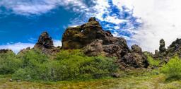
Dimmuborgir ★★★★

Dimmuborgir in Myvatn
Dimmuborgir is a protected area and has been for some years. It is located about ten kilometers south of the village of Reykjavlíð. The site was formed over 2,300 years ago by yet another volcanic eruption.
The lava was chanelled into a 12 kilometer-long canyon south of the Hverfjall crater. The resulting lava lake then solidified into what looks like a rocky field. Water vapor collaborated with the lava bed, heating and cooling each other to create the amazing lava sculptures that Dimmuborgir is known for today.
The chaotic landscape of cones, chimneys, and perforations brings to mind an ancient, twisted citadel: in fact, Nordic legend tells us this is nothing less than the gateway to hell.This is a hostie environment but the vegetation has managed to find root, the greenery contrasting sharply with the black of the cooled lava. Learn more about Dimmuborgir.
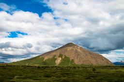
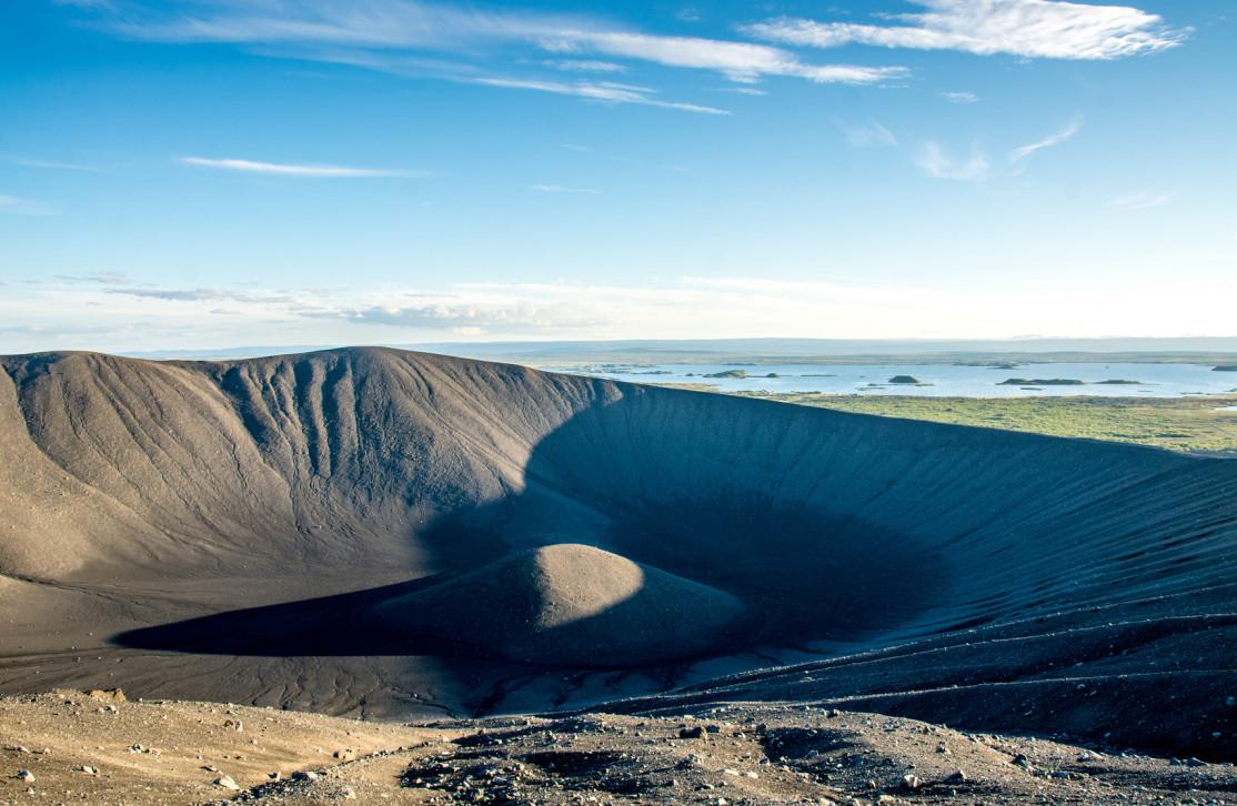
Hverfjall ★★★★★

Hverfjall in Myvatn - 279photo @AdobeStock
Hverfjall, literally “hot spring mountain” in Icelandic, is a volcano located right next to Lake Mývatn. Dated 2,500 years ago, it rises to about 250 meters before plunging 200 meters deep into its mouth, which has a diameter of 1,2 kilometers.
A hike to the summit is highly recommended as the view from the top, sweeping across the lake and surrounding mountains, is a truly unforgettable sight. Additional information on the Hverfjall crater.
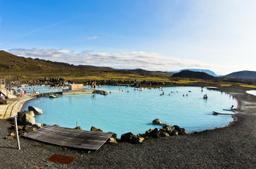
Mývatn Nature Baths - Jarðböðin ★★★★★

Myvatn Nature Baths
Myvatn Nature Bath, or Jarðböðin, is a geothermal resort often compared to the “Blue Lagoon” on the Reykjanes Peninsula. This is the perfect place to rest your weary bones after a good day of hiking in Myvatn.
Jarðböðin is open every day of the year until midnight in summer and 8PM in winter. Witness the magic of the midnight sun in June while submerged in 38° (36 to 40°) water in the middle of a landscape that may as well be on the moon. Learn more about Myvatn Nature Baths.
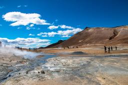
Hverarönd - Námaskarð - Námafjáll - Hverir ★★★★★

Winter - Námafjáll to Myvatn
Námafjáll, the nearby mountain, is a main attraction, but you will find at its foot one of the most interesting geothermal fields in the country, namely Hverarönd.
The site of Námafjáll, also called Hverir, features all the volcanic phenomena you could ask for: solfatars, mud pots, fumaroles...
The place is impressive in it display of power, while the slopes of Námafjáll vary from ochre and sulfur yellow to lava black or slate gray, all peppered with green mosses that contrast with the blue of the sky.
The place is clearly one of the most interesting sites in the region. Additional information on the Namafjall - Hverir website.
Vindbelgjarfjall ★★★★

Vindbergfjall - APD @AdobeStock
Vindbelgjarfjall is one of the peaks in the Myvatn region that you can get to easily if you can handle a short hike, about an hour, to scale it. The departure point is the car park near the access road.
It's not the tallest, culminating at 529m, but offers an exceptional view of the lake. Additional information about the Vindbelgjarfjall hike.
Lofthellir ★★★★

Lofthellir in Myvatn
Lofthellir is a lava cave that is a whopping 3500 years old. It is a fairly small cave since it only extends over 370 m. You'll have to take a guided tour to visit, but it's worth it as this cave has the most beautiful glacial formations in Iceland.
The inside of the cave is cold, of course, and very damp, and as soon as you enter the cave with its magical ice formations you will not believe your eyes.
Some rooms are difficult to access, which will mean some spelunking to reach the most difficult places, but the colors refracted on the ice are definitely worth the physical effort.
Skútustaðir ★★★★

Skutustadir to Myvatn
Skutustadir is near the Stakholstjorn basin of Lake Myvatn. Pseudo-craters abound in this area, which are shaped like craters but do not qualify as there are no lava chimneys underneath.
The place is quite otherworldly you won't soon forget the sight of these moss-covered craters.
Hofdi ★★★

Höfði in Myvatn
Höfði is another interesting site located on the shores of Lake Mývatn. Höfdi Park is a peninsula that reaches out into Lake Mývatn with strange lava formations topped with trees., which are a rare sight in Iceland.
There is a lake cove bordering the park that is adorned with lava pillars, smeared in orange lichens, that rise out of the water and bear the haunting name of Kálfastrandavogar. You can tour the site via a fairly easy hiking trail in less than 1 hour.
The main hiking trail will also take you to a promontory with a stunning view of Lake Myvatn.
Accommodation: sleep in Myvatn
Since it is recommended to stay several days in the region, we recommend staying a few nights there to make the most of it.
For camping enthusiasts, there are two sites near Reykjalhið:
- Hlid Campground
- Bjar campsite
As for guesthouses and hotels, the Vogar Travel Service, in addition to its renowned restaurant, offers accommodation with excellent value. It is just near Reykjalhið, an ideal location for visiting the region.
In the west, the Skutustaðir hotel is also recommended, as is the Dimmuborgir guesthouse located near the site of the same name.