Krafla Volcano
Near the beautiful Lake Mývatn in northern Iceland, Krafla is one of the most active volcanic areas in the world.
Krafla is located right over the Mid-Atlantic Rift and its magma chamber is barely 2 kilometers below the Earth's surface. It boasts a caldera that extends nearly 10 kilometers wide with several volcanoes, craters, and other geothermal phenomena. There are more tourist sites in Krafla than one can imagine, and the area is a must-see when visiting Iceland.
- The Krafla Volcanic System
- Krafla's historic eruptions
- The Viti crater
- Leirhnjúkshraun: the Leirhnjúkur lava flow
- How to get to Krafla
The Krafla Volcanic System

Krafla to Myvatn
The Krafla caldera extends 10 kilometers south from the north of Öxarfjörður into the Ódáðahraun desert. This volcanic system is ancient, the data suggesting it was created during the last glacial period about 100,000 years ago.
To this day, Krafla you can simply feel the heat coming from the Earth at your feet, the heavy with the smell of sulfur. Krafla is one among the major volcanoes in Iceland.
When tourists reference Krafla, which is a huge area with many sites, they are often talking about the two sites where the volcanic system did recent damage:
The landscape of Myvatn: a direct consequence of Krafla

Dimmuborgir, work by Krafla
Eruptions and the many ways lava chooses to exit the earth's crust have created numerous phenomena in the Mývatn region, all sorts of craters, basalt columns, fissures, lava fields or even hot springs.
The sites of interest in the Myvatn region that are a direct consequence of Krafla include:
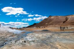
- Namafjall - Hverir
- The Viti crater
- Leirhnjúkshraun: the Leirhnjúkur lava field
- The Dimmuborgir lava fields
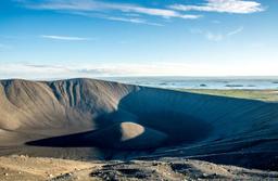
- The Skútustaðir craters
- The Hverfjall crater
- Vindbergfjall mountain
Vindbergjall and Námafjall are well-known landforms in the Myvatn region created during the last ice age. Unlike the Leirhnjúkur eruptions that tore the ground apart, in Vindbergjall and Námafjall volcanic forces created these mountains as the magma swelling beneath the crust never “broke through”.
Hverfjall's eruption, however, definitely broke through with an explosion 2500 years ago. 500 years later, the fire along with the ice of the Laxá river have reworked the landscape of Myvatn, for example the Skútustaðir and Dimmuborgir "craters".
It was only in 1724, following yet another explosive eruption, that the Viti crater was born and much more recently in the 1980s that an eruption created the Leirhnjúkur lava fields which are still hot to this day.
The Krafla geothermal power plant

Kröflustöð, the Krafla geothermal power plant
Near Krafla there is a huge geothermal power plant built in 1975, just before a major eruption, the Kröflustöð power plant. This plant delivers a lot of power to a lot of people, generating no less than 60MW of electricity.
You simply can't miss this installation on the landscape with its red and white boxy buildings and huge pipework. The plant has shafts bored into the crust to extract thermal energy and provide electricity and heating. The power plant can be visited and includes, among other things, a dramatic documentary screening about the famous eruption of 1975.
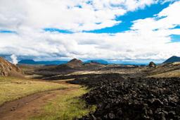
Krafla Eruptions

Krafla lava field
The area is particularly active and there have been 29 eruptions since the big one on May 17, 1724, which created Viti. Two periods of activity were particularly significant:
- From 1724 to 1729: the famous fires of Myvatn and Víti explosion
- From 1975 to 1984: the Krafla fires
From 1724 to 1729, the volcano generated no less than 7 eruptions, nicknamed “The Fires of Mývatn”. The Viti crater was formed during this era and became a maar (small lake within the crater). The eruption itself lasted 5 years, bursting with lava from an 11-kilometer fissure to cover an area over 35 km².
More recently, between 1975 and 1984, a fissural eruption generated enormous lava flows. This was a veritable river over 19 km up to 8 meters deep in places, compacting the earth by 2 to 3 meters. These are the famous “Krafla fires” whose lava fields still smoke today in Leirhnjúkur.
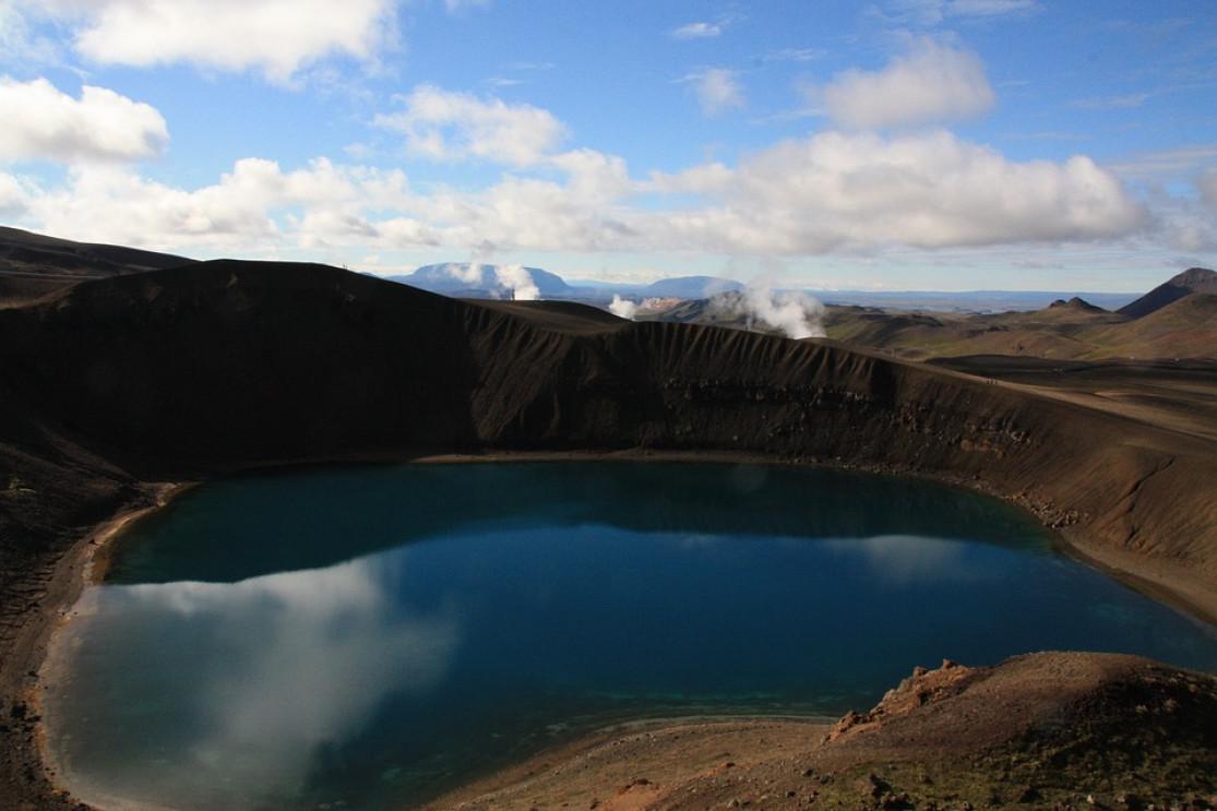
The Viti crater in Krafla

Viti in Krafla
The Viti crater has the particularity of being filled with what is known as a maar, and this one features absolutely crystal clear blue water. The place is a gem, and you can tour the rim of the crater in about 1 hour with an absolutely breathtaking view of the Mývatn region and the Krafla caldera.
The tour is only 1.5 km long, but that doesn't mean it's easy, as the ground is muddy in places. A small car park has been built there, but it is very popular, so in summer we recommend coming in the evening or early in the morning to avoid the crowds.
Leirhnjúkur, next in our article, is only a 25-minute walk from Viti.
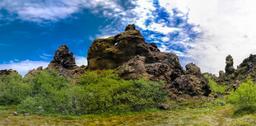
Leirhnjúkshraun: the Leirhnjúkur lava field

Leirhnjukur in Krafla
Just few kilometers from Viti, the Leirhnjukur car park is the starting point of an easy hike, about 1.5 hours with almost no elevation. This trail takes you across the lava fields of Leirhnjúkshraun, which are still hot and heavy with the smell of sulfur.
The volcano, located in the center of the Krafla caldera, is marked with dramatic fissures that extend for about 20 kilometers around it. This was the site of some of the longest and most violent eruptions in the system's history, and you can see it in the landscape.
The green of the moss present near the car park gives way to the gray of the old flows and then to the jet black recent and still hot lava flows. Additional information about the Leirhnjukur hike.
How to get to Krafla

Getting to Krafla is very easy, as the area is slightly north of Lake Myvatn which is a popular destination as well. From Reykjavlíð, it takes only 15 km (15 minutes) to reach the Viti car park, and the Leirhnjúkur car park is only 2 minutes down the same road.
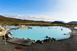
Leaving Reykahlíð heading east, after passing Námafjall and the Mývatn Nature Baths, keep an eye out for the smaller Road 863 that runs north past the Kröflustöð geothermal station to reach the Krafla area.