Askja: our guide to visiting the famed volcano
Located inland on the highlands between Myvatn and North Vatnajokull, Askja is one of the most remote but magical places on the island.
Askja has a legendary reputation in Iceland, but to get there you will have to cross some truly lunar landscapes of unprecedented beauty for several hours before reaching your goal: the enormous crater and its two lakes.
The Askja volcano and its eruptions

The Víti maar in Askja
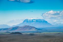
Askja is a volcano located in the center of the Ódáðahraun lava desert at an altitude of 1515 meters and which, at 3000 km², is the largest lava field in the world. The site is part of the extensive Vatnajokull National Park.
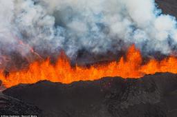
The Askja caldera, as we know it today, was formed 10,000 years ago due to, you guessed it, a major volcanic eruption, the most notable in 1875, and more recently in 1961.
The eruption of 1875 began in January that year and lasted for months. This eruption, in a series of explosions, created the small Vìti crater, known today for its turquoise water. Viti is in fact what's known as a maar: an explosive volcanic crater that sometimes becomes filled with water to create a lake.
After a few decades of peace and quiet, several small eruptions flared up in the early 20th century like warning signs before the major eruption of 1961. A new eruptive fissure tore open in the north-east of the caldera and was active for two months, unleashing no less than 100 million square meters of lava.
Askja: an exceptional site

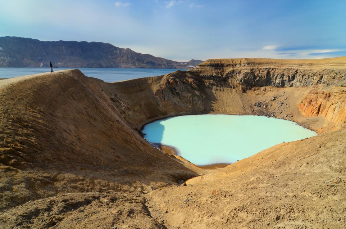
Askja: Víti in the foreground and Öskjuvatn in the background - Martin M303 @fotolia
NASA's first moonwalkers came here to train, which says a lot about the region. This is an active volcanic zone and the caldera extends over 45 km². In Askja, there are two beautiful lakes:
- Lake Öskjuvatn
- The Vìti crater and its lake
Lake Öskjuvatn

Öskjuvatn and Viti - Ronan Furuta @Unsplash
The crater is home to a splendid crystalline blue lake, Öskjuvatn which is 217 m deep, and together with Jökulsarlon is one of the deepest lakes in the country.
Vìti crater

Tourists who are going to swim in Víti in Askja - Davide Candelli @Unsplash
Very close to Öskjuvatn lies Vìti, a crater with warm, milky waters. Unlike Öskjuvatn, its waters are pale green, and this contrast makes the place very photogenic.
Some tourists choose to climb down in to the crater to swim in its warm waters (25 to 28° regardless of the season). But take care on your way down into the heart of the crater, as the slope is very steep and the descent can be dangerous, so follow the guide's instructions.
On site, the contrast between Viti and Öskjuvatn is striking, and the site is a haven of peace and quiet, a truly magical place with that characteristic sulphur smell.
A typical hike in the Askja Caldera departs from the car park to reach Öskjuvatn, passing the small Vìti crater on the way. It takes 1.5 hours to 2 hours to complete the round trip.
How to get there
Askja is completely isolated, a remote location in the center of Iceland, far from any city and well off the main roads. Access to Askja requires an all-terrain vehicle (4x4) whether you are coming from the north or the east. The off-road trails are quite rough overall, so going to Askja takes time. It'll be a full day excursion including travel time from Road number 1 and a complete visit of the site. Altogether, driving time will be a full 5 hours for a return trip regardless of the track taken.
There are two ways to reach Askja:
- The F88
- The F910
The other alternative is to book a guided tour with a tour company (see below).
Access via the F88

The main access to the site is from the north, a few kilometers after Myvatn, but the F88 trail is a challenging one with fairly deep fords (about 60 cm or more) and areas of black sand. It is not the most popular track because the F910 is simply much more photogenic and the Lindaá ford can be very deep or even impossible to pass. This is the Jökulsá á Fjöllum river which runs to the Dettifoss waterfall.
The F88 is accessible from Road number 1 and at first is rather monotonous despite the frequent bumpy “corrugated iron” sections for the first 45 minutes. We then arrive at the first ford, quite easy because shallow, while the Ódáðahraun river flows in the background.
It's only a few kilometers further that the going gets tough with the famous Lindaá ford. The ford is wide and a sign indicates that this ford can be complicated for standard 4x4s (SUV rentals as opposed to super jeeps). There is a depth gauge made up of a rope to indicate where the water level is the lowest on the ford.
After a swampy section, you finally approach to the imposing Herðubreið which culminates at 1682 m, an extinct volcano that dominates this desert landscape with its plateau.
The trail then becomes a much more pleasant drive to Askja, with the vegetation giving way to the vast lava field.
It takes 2 hours to travel the 100 km between Road number 1 and Askja on the F88 trail.
Access via the F910

This trail, along with the F225 leading to Landmannalaugar, is considered one of the most beautiful in the country. The F910 trail is a 115 km stretch of desert ash, sand, and breathtaking landscapes.
On the road, the flora is almost non-existent and the landscape is like another planet entirely. Starting from the last villages near Lake Lagarfljót, make sure to fill up the fuel tank since there are no service stations on the road leading to Askja.
Many tourists stay overnight in the very famous guesthouse in Adalbol. In addition to being the closest to Askja, the hosts are particularly welcoming.
It takes about ten minutes to get from Adalbol to Bru, but the next 25 km to reach the junction with trail 905 are a bit more difficult, the road surface uneven and a great deal of sand, which can affect vehicle traction (photo). The landscape is extraordinary with a few rare fords glimmering in the Ódáðahraun Desert.
After a few kilometers south on the 910 you'll reach 2 fords which are generally quite easy (30 cm to 40 cm deep at most).
These 2 fords are the big ones you need to cross to reach Askja from the east. Then the trail gets even more difficult, with rough terrain such that the last kilometers to reach Askja can seem endless. The sand gives way to a very rocky track and the vehicle speed can hardly exceed 30 km/h.
Ultimately it takes 2.5 hours to get to the Drekagil campsite from Adalbol, and this counts the time you need to admire these unique panoramas , including the Herðubreið volcano, which rises to 1682 m and dominates the region.

We recommend you continue 8 km via the F894 to the Öskjuvatn car park to get a little closer. This will mean you only need to walk for 30 minutes (2 km) to reach the site, which is absolutely exceptional. A true jewel of Iceland!
Many tourists arrive from the east these days, through the Kárahnjúkar and Egilsstadir regions via the F910 trail. There are more fords to cross but they post no challenge (if you have to choose, take the right bank of the Jökulsà).
On the road you are likely to encounter meeting reindeer, which are rare but concentrated in this region of the island, so keep your camera handy to snap a shot of Rudolph.
Askja in guided excursion mode

Some tourists prefer organized day trips to avoid driving on these trails with their rental vehicles.
Tours with departures from Akureyri or even Myvatn are common. They will take you there either via 4x4 bus or a superjeep. Generally it's a full day excursion, total 12 hours for the trip there, the tour, and the return trip.