The Fagradalsfjall Volcanic Eruption
On March 19th, 2021 at 9:45PM, the Reykjanes Peninsula in south-western Iceland became the scene of a cataclysmic event, the Geldingadalsgos eruption.
Numerous warning signs predicted the event, and even pinpointed the epicenter near the Fagradalsfjall mountain in the Geldingadalur valley. The eruptive fault appeared halfway between Lake Kleifarvatn and the famous Blue Lagoon, in fact less than 10 kilometers from the spa resort.
A common misconception is that this was the eruption of the Fagradalsfjall, which is the name of the closest mountain. This event was not a volcanic eruption but a small fissural eruption, completely different from the large volcanoes in Iceland and their occasional eruptions. Geldingadalsgos, the actual site of the eruption, is located in the Geldingadalur valley, the “valley of the geldings”.
- Volcanism in the Reykjanes Peninsula
- The 2021 eruption of Geldingadalsgos
- When and how to visit the eruption site
- The hiking trail to the eruption site
- The 2022 eruption in the Meradalir Valley
- The 2023 eruption near Litli Hrútur
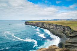
Volcanism on the Reykjanes Peninsula

Seismic activity in Reykjanes in March 2021
The Reykjanes region is known for its frequent earthquakes, as this southern region is located right on the Mid-Atlantic Ridge. Several volcanic systems lie underground here, and chained together these form the “Reykjanes Volcanic Belt”. Suffice to say this is a region with significant seismic activity. Volcanoes abound, of course, but there are also numerous eruptive vents, including:
- Krýsuvík
- Reykjanes
- Svartsengi
- Fagradalsfjall
- Brenninsteinsfjöll
The Eurasian and American tectonic plates connect right under this region, pulling apart about 2cm every year, and this activity is particularly visible on the Reykjanes Peninsula.
This is a region prone to tremors and volcanic events, despite the fact that the main volcanic system, Krýsuvík, has been inactive for 900 years. Before March 19th, 2021, the last eruption on the Reykjanes Peninsula dated back to 1240...
The 2021 eruption of Geldingadalsgos

The rift near Fagradalsfjall
As early as 2020 the Icelandic authorities noticed a marked increase in local tremors, with nearly 20,000 tremors recorded in the year without an eruption...
This trend accelerated again in early 2021 on the south-western tip of the peninsula, with underwater tremors that moved inland, near Lake Kleifarvatn. Specialists predicted an imminent eruption for late February, pinpointing Mount Keilir as the site of the eruption.
These earthquakes often indicate a future eruption. Geologists also noted deformations in the crust, had become incredibly swollen in places.
In early March, almost 40,000 earthquakes were recorded in the region, some reaching a magnitude of 6.5, and magma was detected just 1 km from the Earth's surface.
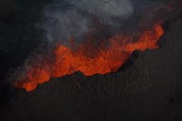
On March 10, the authorities announced a 10-kilometer-long fault (photo) had appeared near Fagradalsfjall, which suggested an eruption nearby. The fault continued to fill with magma at a rate of nearly 20 m³ per second.
The following week saw a fairly significant decrease in earthquakes in the region, but this did not mean the danger had passed. Specialists predicted an eruption in the following days. On 18 March, Road 427 between Grindavík and Kleifarvatn collapsed due to seismic activity.
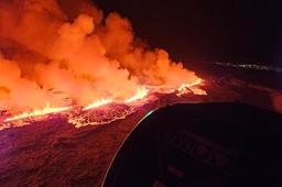
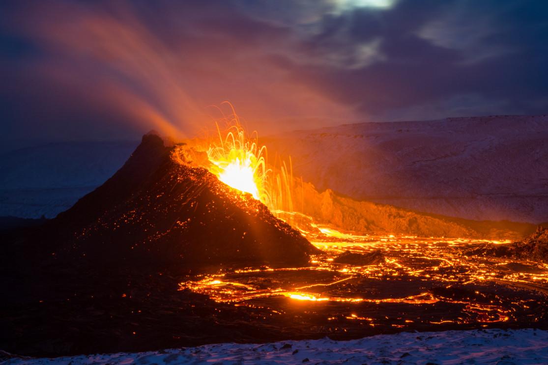
The start of the eruption on March 19th, 2021

Eruption of the Geldingadalur valley in March 2021 - Gestur Gislason @Dreamstime
After a morning marked by strong seismic activity, at 9:45PM local time the Icelandic sky turned red as the eruption began. This was at first a small eruption, the fissure no more than 700 meters long and located at the foot of the Fagradalsfjall mountain as predicted by specialists a few days earlier.
The lava flow at the time covered barely 1 km² and there were no habitations nearby. The next day, Icelanders, who are rather casual about volcanic eruptions, did not hesitate to pay the place a visit. Thousands of curious locals began streaming in to admire the eruptive fault.
On March 23 the authorities set up a marked trail to guide visitors to the eruption, with traffic jams reaching several kilometers! In the days that followed the Geldingadalur valley filled with lava, and specialists then announced this eruption could last for many months. At this point, the lava was leasyred at nearly 20 meters thick, and the main crater 100 meters high!
An interminable eruption...

Tourists near the eruption on March 25th, 2021 - Sofya Dushkina @Dreamstime
By the end of March, the Geldingahraun lava field was reaching capacity, and it became clear that the lava would continue to flow through the valley heading south...
The two craters partially collapsed in the last days of March. The eruptive fissure changed its form and this affected the lava flow, reducing it to about 5 m³ per second. The end of the eruption, however, was still not in sight! Volcanologists determined that this lava flow could continue for a very long time as it came directly from the depths of the earth rather than a magma chamber.
On April 5th two new eruptive vents appeared a few hundred meters east of the original craters. This new fault reached nearly 500 meters long, the lava flowing into the Meradalir Valley. Several new faults appeared over the following days, and the output flow remained around 10 m³ per second.
On May 1, more than a month after the eruption began, a 50-meter-tall lava fountain appeared, stunning everyone, and the fault had reached almost 1 kilometer in length and counted about ten craters.
After pausing for 9 days in mid-September, the eruption started again, even increasing in intensity as if to celebrate its 6 month birthday and its record as the longest eruption in Iceland in more than 50 years.
When and how to visit the eruption site

Located less than 20 kilometers from Keflavik and about 40 kilometers from the capital Reykjavík, the eruption site is fairly easy to reach. However, we recommend you consult the official information bulletins that change daily on the official Safetravel.is website and indicate if it is safe to visit these sites.
By car from Reykjavík the easiest way there is to go south on the 42 which runs alongside Kleifarvatn before turning off on Road 427 towards Grindavík.
There are also tour buses to get there via Reykjavik Excursion:
- https://www.re.is/tour/volcano-bus/
An “official” parking lot has been set up to avoid any visitors losing their cars to the lava. You'll find it at the red dot on the map above, located at GPS coordinates: 63°51'54.0"N 22°18'54.2"W/63.865000, -22.315056.
As destructive as they may be, volcanic eruptions make for some great photos. You'll find yourself trying to get that perfect shot. Even though the site is quite safe, take all necessary precautions and don't go without checking safetravel.is first.
On site, depending on the wind direction, toxic gases can be blown in the direction of visitors, which can be dangerous, but this is once again something that can be checked on the safetravel.is website.
The safest and best view is without a doubt by flying over the area in a tour helicopter:
The hiking trail to the eruption site

Tourists near the eruption in March 2021 - Sigurbjornragnarsson @Dreamstime
Two marked trails approach the main crater, one from the west and another from the south (see map of the trails below).
- Be sure to pick up the free map to download on your mobile provided by safetravel.is.
Do not leave without a working means of communication and good hiking boots, even if the trail is relatively short. On site, you must respect all safety instructions, especially when approaching the lava field.
The car park is located 10 minutes east of Grindavík and 1 kilometer east of the start of the hike. The trail is well-marked as it cuts into the valley and west of Mount Borgarfjall and from here, there are a few variants:
- Trail A, GPS tracking
- Trail B, GPS tracking
- Trail C, GPS tracking

Trail A is the most direct, totalling only 4 kilometers (one way) with one fairly steep section but otherwise little elevation. It takes 2 to 3 hours to make the return trip. Unfortunately, it has now been closed since the end of June.
Trail B is a bit longer but takes about the same amount of time with a steep section at the end.
There is now a slightly longer trail marked C (on the right), which goes around the flow on the East side.
These hiking trails are only open from 6AM to 6PM, and the site is fully evacuated at 10PM.
You can also take a guided hiking tour from Grindavik.
The eruption in the Meradalir Valley in 2022

The eruption of August 3, 2022 in the Meradalir Valley - SenatorJoanna @dreamstime
In late July 2022, seismologists rang the alarm bells once again with thousands of minor earthquakes registered on the Reykjanes Peninsula in just 4 days. On August 3rd a new eruptive fault ripped open on the flanks of Fagradalsfjall out of which gushed a massive flow of lava.
The fault is located in the Meradalir valley, still close to the Fagradalsfjall mountain, in fact only one kilometer from the previous fault in the Geldingadalir valley.
Since August 19th the lava flow seems to have decreased considerably, and as the eruption itself is not generating ash clouds or explosions, it is safe to approach much like its predecessor.
Getting to the eruption site

Path A is the path to take. (https://atlas.lmi.is/)
3 walking trails were laid out to observe the eruption, but we recommend trail A as it offers the best experience overall. The hike is not very complicated but it does take time to complete the 7 km to get to the viewpoint. Whatever you do stay on the path as it can be very dangerous, which is why children under 12 are forbidden from these visits.
Car park 1 (1000 ISK for the day) is your only option, then just follow trail A. The return trip is 14 km and it will take a solid 4 hours or 5 hours, not counting the time you spend just gazing at the majestic scenery. Elevation is minor (about 300 meters) but there are rocky sections that slow everybody down.
And as always you can also book a group tour of this hike with a guide if you prefer: