The Reykjanes Peninsula
The Reykjanes Peninsula is, for the most part, where the adventure begins when you arrive in Iceland. It extends from Keflavik Airport to Reykjavik, about 50 kilometers further east.
This region of Iceland is paradoxically very often overlooked by tourists except for those staying in the capital Reykjavik, and of course, the famous Blue Lagoon, but there is much more to see.
This is a region particularly rich in geothermal phenomena, full of hiking trails and other activities, and given its ease of access it's the perfect playground for short stays in Iceland when you can't wander too far from Reykjavik.
The Reykjanes Peninsula

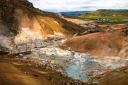
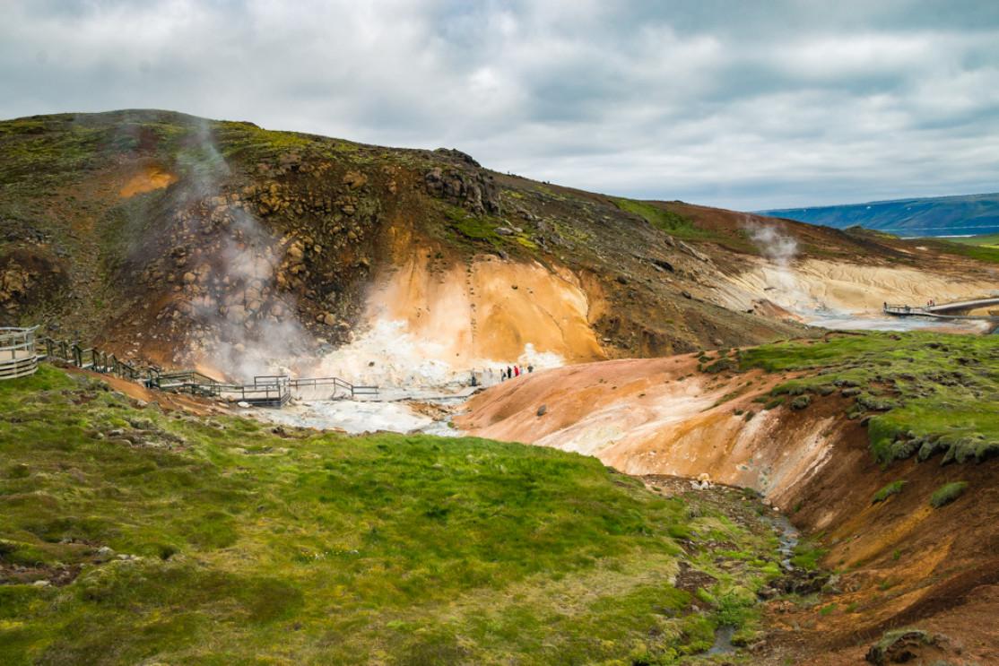
Seltun to Krysuvik
The Reykjanes region is known for its small earthquakes, being located on the fault line that separates the Eurasian and American tectonic plates. Fascinatingly, right under your feet the plates are actually moving a few centimeters apart every year, and when the tension builds it causes these small earthquakes.
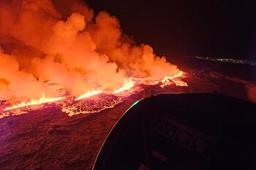
The peninsula is in fact a huge lava field with very active geothermal and volcanic activity, and it's quite a culture shock when you get off the plane for the first time in Iceland and discover the lunar landscapes of Reykjanes.
Here you'll find all the phenomena linked to the dance of fire and water underground, things such as mud pots, solfatars, and fumaroles. And while you can find bigger and better examples at the four corners of Iceland, they can be seen just near the airport. The region's geothermal energy is actually tapped to heat the city of Reykjavík, and is how the famous Blue Lagoon delivers all that hot water via the Svartsengi powerplant and waterworks.
The roads that take you around the peninsula, including the 41, 425, 43, 42 and 427, are in very good condition, although they may not always be paved. Even so, a traditional passenger car is more than enough to explore the peninsula as long as you don't go off-road...
Reykjanes can be visited in winter and summer alike, as the peninsula is somewhat protected from the harshest climates, unlike other regions in Iceland.
Points of interest in Reykjanes
Overall, the northern part of the peninsula is where you'll find the main towns and villages:
- Keflavík
- Sandgerði
- Vogar
Keflavik is the biggest one on the peninsula and hosts the international airport.
The first point of interest is in Krysuvik, the place right on the fault line of the Atlantic Ridge that crosses the island from south-west to north-east. Road 42 gets you there from the north and east, and road 427 from the south-west, and you can find all kinds of geothermal phenomena there including eruptive faults, lava flows, mud pots, and volcanoes (especially in Seltun).
Being located just where the American and European tectonic plates are pulling apart, it's a symbolic place and there is a bridge to pass from one side to the other (south of Hafnir).
To the west of Krýsuvík rises Mount Keilir up to 385 m. Hikers can take the trail ascending to the summit to admire the view of the Reykjanes Peninsula which is well worth the climb, especially on a clear day.
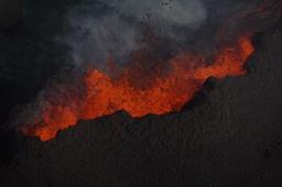
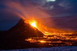
It was near this mountain that the famous eruption of Geldingadalur took place in March 2021 and the hike is a chance to see the damage from a bird's eye view!
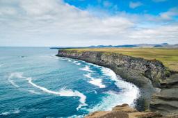
Bird watchers will love a trip to the south coast to spy the cliffs of Krysuvikurberg rising nearly 70 meters high, and observe the local puffins, murres, and fulmars. You can get there via a small trail that runs parallel to Road 427 at the extreme south of the peninsula, a bumpy trail but only a few kilometers long and the place is definitely worth a visit.

On the road leading to the south coast, you will find the beautiful Kleifarvatn lake. Its rich bird population alone is worth the detour, and legend has it that the lake is inhabited by a sea monster half-whale and half-snake... This lake is also popular for boating expeditions to observe the Northern Lights in winter and at night, the place is even more magical.
Lake Kleifarvatn is considered to be the deepest lake in Iceland, almost 100 meters. If you continue along the coast to the south-western tip of Iceland, you arrive at Gunnuhver, another geothermally active zone. But this one is special, one of the hottest geothermal zones in the region with temperatures rising to 300 °C! So keep your wits about you as you admire the mud pots and fumaroles spitting steam into the air.

Very close to Gunnuhver, Brimketill is a natural swimming spot like a jacuzzi right on the seashore. The constant battering of the waves crashing against the lava rock eroded a pretty little pool which is popular with the locals.
For architecture fans, two churches are particularly interesting around here: one in Hvalsneskirkja near the airport with its original design, and Strandarkirkja on the south coast.
It is also on the Reykjanes Peninsula that you can see Thrihnukagigur, located in the Bláfjöll Mountains area, the only place in the world where you can visit the interior of an active volcano.
Last but not least, you can't mention Reykjanes without talking about the Blue Lagoon! The peninsula is home to the most visited tourist site in the country, the Blue Lagoon. Its waters are naturally rich in healing silica, mineral salts, and seaweed which creates that milky turquoise blue color.
Excursions depart every day from Reykjavík for day tours of the peninsula, stopping at most of the attractions on the peninsula (including, of course, the Blue Lagoon).