Snaefellsnes: Travel guide
The Snaefellsnes Peninsula is located in the westernmost region of Iceland, 150 km north of Reykjavik and a 2-hour drive from the capital.
Often referred to as “Iceland in miniature”, the region owes this reputation to the great variety of landscapes it offers.
- Snaefellsnes Peninsula
- Snaefellsjökull National Park
- When should you visit Snaefellsnes and how much time should you spend there?
- How to get to Snaefellsnes?
- Accommodation: where to stay in Snaefellsnes?
- What to see in Snaefellsnes?
- Organized excursions in Snaefellsnes
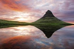
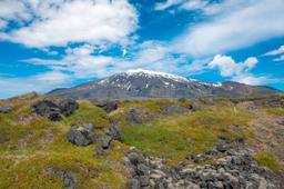
The beautiful Snaefellsnes peninsula

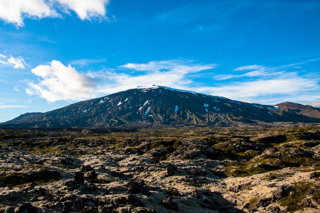
Hellnar surrounding area
The majestic Snæfellsjökull volcano is of course the most well known feature. Located at the western tip of the peninsula, it dominates the area from a height of 1446 m. When skies are clear, it can be seen from Reykjavík 150 km away. Its summit is snow-capped all year round, though sadly the ice shelf decreases year after year due to global warming.
This volcano was put on the map by Jules Verne who depicted Snaefellsjökull as the gateway to the planet core in his mythical work “Journey to the Center of the Earth”. More recently, “The Dream Life of Walter Mitty” with Ben Stiller and season 7 of the famous Game Of Throne series were shot on location.
The population is small, with only about 3,000 inhabitants in total. With the exception of Arnarstapi on the south coast, the main towns are strung along the north side: Rif, Ólafsvík, Hellissandur, Grundarfjörður, Búðardalur and Stykkishólmur. As is often the case in Iceland, fishing is the main local industry.
The main port of stay for visitors is Stykkishólmur, as its harbour delivers tourists by the boat-load to the western fjords via the small and picturesque island of Flatey.
Snaefellsjökull National Park

The majestic Snæfellsjökull
Iceland has only 3 national parks: Skaftafell National Park and Vatnajökull National Park are further south, while the 170 km² of Snaefellsjökull National Park stretch over this peninsula.
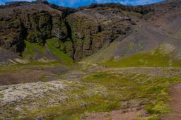
The park has many sites of interest, the main one being of course the Snæfellsjökull volcano itself. The national park is bordered by the edges of the volcano, from Hellissandur and Londrangar to the west coast. The park includes is home to a range of ecosystems, with vivid mosses stark against the lava fields and lupines growing wild.
The wildlife of the peninsula is known for its local seabirds. such as the common and thick-billed murres, the northern fulmar, the black-legged kittiwake and the crested cormorant. They are particularly present along the coast, near cliffs such as in Londrangar, Arnarstapi, and Hellnar.
In addition to avifauna, marine mammals are the other rock stars of the region. Harbor seals and gray seals occupy beaches mainly to the south and Minke whales and killer whales navigate all around Snaefellsnes. Arctic foxes are local to this area as well, especially near cliffs where they can steal tasty eggs.
When should you visit Snaefellsnes and how much time should you spend there?

Snaefellsnes is well worth visiting whatever the season. Being located near the capital it's ideal for short stays in winter, especially since the road conditions are quite good, so you can easily get to spots such as Kirkjufell or Budir to capture stunning photos of the Northern Lights.
In summer, people visit the region for the beautifully green natural scenery. Being far west, the area is fantastic for observing the midnight sun with viewpoints known throughout the country such as Rif, Öndverðarnes or Hellissandur.
Usually 2 days are enough to visit Snaefellsnes: one day on the north, another on the south coast. It all depends on your schedule as some hiking trails near Snaefellsjökull (see the Snaefellsjökull hikes) will take upto a whole day.
How to reach the peninsula

From Reykjavík, there is a handy bus line to get to Snaefellsnes.
If you're driving, the good news is there's no need to rent a 4x4, a standard vehicle is more than enough to get you safely around the peninsula as the condition of the roads is quite good.
The 54 road runs all the way around the peninsula and the 574 ends Snaefellsjökull. 3 main roads cut the peninsula from south to north, specifically the 54, 55 and 56. Not all roads are paved but the dirt roads are in good condition.
Driving here is particularly beautiful, especially the 54 with the most scenic panorama, while others will give you a VIP view of the delightful Kolgrafarfjördur fjord in the north near Grundarfjörður.
From Reykjavik, road number 1 then the 54 from Borgarnes can get you to this natural wonderland in 2 hours.
Accommodation: where to stay on the peninsula?

Accommodation options are many around the peninsula but it is very popular all year round so it's recommended you book a little in advance.
For camping enthusiasts, good news! There are several campgrounds all around the peninsula.
On the north coast:
- Stykkisholmur Campground
- Kirkjufell Campground
- The Setberg Campground
- Olafsvik Campground
On the south coast:
- Arnarstapi Campground
- Traðir Campground
For those who prefer comfy hotel beds or a quaint bed & breakfast, on the north coast we strongly recommend the Stundarfridur hotel for a great bargain and the friendliness hosts you could ask for.
On the south coast, our favourite bed and breakfast is the Blue View Öxl, it is particularly well-located, closer to the church of Buðir, and is great value for money with impeccable service.
Snaefellsnes places of interest
No shortage of fantastic things to see around the peninsula as you can see on the map above. The Snaefellsjökull National Park is the main attraction, with its numerous hikes on the Snaefellsjökull volcano. Below you will find a short list of our top recommendations.
-
Kirkjufell ★★★★★

Kirkjufell
One cannot leave this region without seeing Mount Kirkjufell. Kirkjufell can be translated as “the mountain church” probably thanks to its almost otherworldly pyramid shape. It dominates the north coast of the Snaefellsnes peninsula near Grundarfjordur.
Located right on the shore, the mountain seems to rise skywards straight out of the ocean. It is the most photographed site in Iceland, and the bar is high in this part of the world, so be sure that Kirkjufell is a must-see! More information on our article dedicated to Kirkjufell.
-
Arnarstapi and Hellnar ★ ★ ★ ★

The village of Arnarstapi
Two charming little villages in the south of the peninsula are well worth visiting. The statue of Bardur dominates the port of Arnarstapi and will be watching over you during your stay. Bárður is half-human, half-troll and, legend has it, became a spirit when he disappeared into the Snaefellsjokull glacier.
Arnarstapi and Hellnar are best known as the opposed starting points of a well-known hiking trail that runs between them along the sea, a truly delightful excursion with magic along the way, such as the famous arch-shaped Gatklettur rock that rises out of the sea. More information on our article dedicated to Arnarstapi and Hellnar.
-
Budir ★ ★ ★ ★

The black church in Buðir
The intriguing but no less superb church in Buðir is the other local subject that photographers can't get enough of. It is located on the south coast, at the junction between Route 54 and 574.
The church is jet black and seems lost in the middle of nowhere, a deep shadow on the vivid green of the grass pooling around it, framed by the blue of the sky and sea, for a particularly striking effect.
-
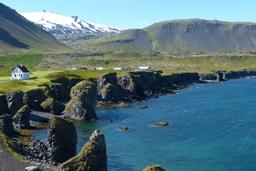
Ytri Tunga ★ ★ ★ ★

Ytri Tunga is a small but quaint farm located along road 54 in the south. This farm is known for its neighbors, specifically the residents of the local beach, a colony of seals young and old who have called this place their home for many years.
They are so popular that the area features a car park and watching station for visitors to observe and photograph the adorable seals.
-
Londrangar ★ ★ ★ ★

Londrangar
Close to Hellnar in the south-west you will find the Londrangar site. Two rock towers dominate the sea front, one rising to 75 m and the second to 61 m.
According to a local legend, they are no less than trolls in disguise! It's a beautiful spot to visit, especially in summer when the conditions are ideal for the midnight sun. More information on our article dedicated to Lóndrangar.
-
The Raudfeldsgja Canyon ★ ★ ★ ★

Raudfeldar Canyon
The Raudfeldar Canyon is located just near Arnarstapi in the south. The canyon takes its name from a local legend of half-troll half-human beings. Legend has it that Rauðfeldur, who was playing with his cousin Helga, accidentally pushed her onto an iceberg that then drifted over the horizon to Greenland.
Helga's father, Bárður, who was obviously upset, pushed Rauðfeldur into the canyon that became his tomb: the Rauðfeldar Canyon. The story goes on with Bárður take refuge and that if you are lucky you can glimpse him from the top of the canyon! More information in our article dedicated to Raudfeldsgja.
-
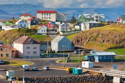
Stykkisholmur ★ ★ ★

The port of Stykkishólmur
Stykkishólmur is a picruresque little port on the north coast and is the largest town on the peninsula, a departure point for the ferry to Westfjords and the island of Flatey.
Its port is known for its superb basalt columns, which create a striking visual tableau. It is also in this village that the Volcano Museum can be found, retracing the history of the mighty Snaefellsjökull. More information in our article dedicated to Stykkishólmur.
-
The Gerduberg columns ★ ★ ★

Gerduberg - Joma @wikipedia
At the south-east entrance to the Snaefellsnes region, at the junction between route 567 and 54, rise the Gerduberg Cliffs. It is the largest basaltic escarpment in the country, with some basalt columns reaching up to 14 m.
-
Eldborg ★ ★ ★
The nearby Eldborg crater is a sigh to behold, 50 m deep and 200 m in diameter. It's a 90-minute hike to and from the “Fire Castle”, taking you meandering along a stream to the foot of the crater. The hike sets out from the parking lot at the Snorrastadir farm. More information in the article about Eldborg.
-
Öndverđarnes Lighthouse and Skardsvik Beach ★ ★ ★
Öndverdarnes is the westernmost tip of the peninsula, and is home to the Svörtuloft lighthouse. Svörtuloft literally means “black peaks” after the cliffs it was built upon.
These cliffs were formed as lava churned and cooled during the eruptions of the Snæfellsjökull volcano. Skardsvik Beach next door is a beautiful sand beach hemmed in dramatically by the black cliffs of Svörtuloft.
-
Dritvik Bay and Djúpalónssandur Beach ★ ★ ★

A little further south, a trail leads to the seashore in Dritvík Bay, where tucked away you will find the beautiful black pebble beach known as Djúpalónssandur. After a short walk you can enjoy this beautiful beach surrounded by perculiar rock formations similar to those found near Hellnar. More information in the article Dritvik and Djupalon Beach.
-
Bjarnarfoss ★ ★ ★
At the junction of routes 574 and 54 near Buðir is the Bjarnarfoss waterfall which simply can't be missed. Indeed, you can spot this beautiful 80m waterfall being whipped by the wind from a great distance.
-
Langaholt's white sand beach ★ ★ ★
While most beaches in Iceland are black sand, there are some exceptions. Langaholt Beach is a 5-minute walk from the village of the same name, along Route 54 in the south near the Ytri Tunga farm.
The beach is striking with its beautiful orange-yellow tones, while the ocean swell is strong and forms magnificent rollers. The contrasts between the color of the sea and the beach are simply astounding.
-
Vatnshellir Cave ★ ★ ★
Near Londrangar in the far west there is a volcanic cave that dates back 8,000 years. You need a guide to take you 35 meters under the ground down windy staircases to explore the 200 m cave network.
This tour is a great alternative in case of bad weather for example, but the colours of these minerals are worth a visit in themselves. Capacity is limited, so it is strongly recommended to book in advance: more information and reservations. Additional information in our article dedicated to caves in Iceland.
-
Songhellir Cave ★ ★ ★
Finally, between Anarstapi and Raudfeldsgja in the bowels of the earth lies the Sönghellir cave, known as “the cave that sings”. The quality of its acoustics are world famous. This cave can be visited without a guide, unlike Vatnshellir, and won't cost a penny.
Organized excursions in Snaefellsnes

The many excursions in the region, some of which leave from Reykjavík, are available all year round. Here is a selection.