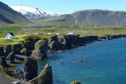
Dritvik Cove and Djúpalónssandur Beach
Dritvík is a picturesque cove in western Iceland bordered by the Djúpalón and Djúpalónssandur, two superb black pebble beaches appreciated by locals for their rich history.
Djupalon beach is also called "the black lava beach". Dritvik and Djupalon Beach two of the many points of interest you will find on the Snaefellsnes Peninsula.
The Dritvik creek is bordered by a lava field on 3 sides, with Dritvíkurmöl, the Dritvíkurpollur pond, and the Vikurklettur Rock to the north and the sands of Mariusandur extending to the south.
How to get to Dritvik and Djupalónssandur
The western tip of the Snaefellsnes peninsula is home to several magnificent beaches, first and foremost Skarðsvik near the Öndverðarnes lighthouse.
Heading north your way to Londrangar along the famous Road 574 that runs the coastline of the Snaefellsnes peninsula, you'll be looking for the exit onto the small Road number 572.
After 1km you'll reach the Dritvik car park. Notice boards in the parking lot will inform you about the site, which is a departure point for several hiking trails, so rest assured it's all very well indicated.
The Dritvik car park is only 300 meters from Djupalonssandur Beach.
Dritvik's History
A heritage steeped in fish
This cove is a symbol for Icelanders, a place steeped in history. From the mid-16th century to the mid-19th, Dritvik was a thriving seasonal fishing base with the most activity in the country.

Back in the day, between April and mid-May, you would see no less than 50 rowing boats leaving Dritvik carrying 200 to 600 fishermen on board. And at the edge of the nearby lava field, you can still see the remains of enclosures where the fish they caught were dried for the market. The Brjotur and Barðarskip rocks, rising out of the cove's waters, were like the gates that the boats came through to dock.
The Epine GY7 trawler
Dritvik is also infamous for another reason, when English trawler Epine GY7 sank like a stone there in 1948. More specifically a cold winter night on March 13, 1948, when the trawler was caught in a storm near the coast of Dritvik. Despite the help provided by Arnarstapi and Hellisandur, the ship ran aground on the reefs east of Dritvik.
The tide was rising, and the craft was mercilessly pummeled by waves. Fourteen men lost their lives in this shipwreck and many were never found, but there were five survivors thanks to the locals.
Today, traces of the trawler still remain on the beach, fragments, flotsam, and jetsam that seems to blend into the scenery. These remains are protected and should not be touched as they have become an open air museum, and in many ways commemoration dedicated to the fishermen who lost their lives here.

The round stallion stones of Dritvik
On the path that leads to Djúpalónssandur beach you'll find 4 round, smooth stones of different sizes, and they aren't there by accident. The Dritvik stones were in fact used to measure the strength of Icelandic fishermen in the past.
These tests of manhood even have a name:
Fullsterkur (full strong): 154 kg
Hálfsterkur (half-strong): 100 kg
Hálfdrættingur (half-carrier): 54 kg
Amlóði (hamlet or weakling): 23 kg
To get a seat on a fishing boat before even trying to catch a fish, the candidate had to lift the Hálfdrættingur, i.e. 54 kg. As you can imagine, many tourists (mostly men) try to lift them to prove they are not a "weakling".
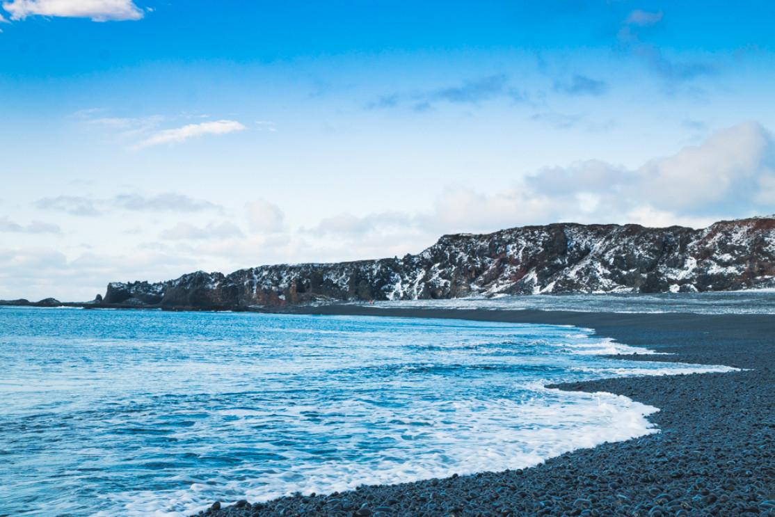
Djupalonssandur beach
This beach is particularly beautiful, especially right at the waterline where you can clearly see the smooth black pebbles being tossed in the surf, known locally as the “black lava pearls of Djúpalón” (Djúpalónsperlur).
Here you will also find the rusty remains of the famous Epine trawler. Like a haunted house, the beach now has a mythical and ominous atmosphere in addition to its picturesque landscape.
But things of beauty in Iceland are often dangerous, and this beach along with Reynisfjara near Vik are known to be the most dangerous in the country. At rising tide the sea swell here is immensely powerful, battering the pebble beach with colossal waves, so keep your wits about you!

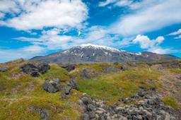
A little further inland, you will find two small lagoons: Svortulón and Djúpulón. Svörtulón is located near the car park and another feature of the landscape: the Gatklettur Rock, a lava rock with a hole in the middle through which you can photograph the Snaefellsjökull glacier.
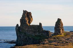
There is also a rock on the beach south of Dritvik that as is very often the case in Iceland has a name. The Söngklettur or "singing rock" is easily recognized for its reddish tones and according to local legend is the Church of the Elves (Tröllakirkja).
Dritvik hikes

Several hiking trails leave from the car park, and you can consult the signs on-site for directions with an estimated walking time.
The main hiking trail is the Nautastigur trail, simply marked “Dritvik” on the signs, which is only 1 km long. Leaving the car park you'll pass Gatklettur with its hole in the middle before turning back down to the beach between two large cliffs. The famous round stones will be waiting for you on the beach along with the “stalur” platform, which is how high you need to lift one if you want to get hired as a fisherman...
The path takes you along the beach to the end of the creek and the Söngklettur rock. Next you'll be crossing Suðurbarði where lie the mysterious remains of an old labyrinth made of stones. The hike ends near the Kerling rock, a legendary troll woman petrified at sunrise. Iceland is dotted with rocks named Karl and Kerling that are named in pairs (man and woman). Here, the man happens to be a bit further away, in Londrangar.
This walk takes only 30 minutes.

From the car park, there are two other hiking trails in addition to the nearby Utsyni viewpoint: One of them leads to Einarslon and can be done in 20 minutes (1.2 km), for another perspective of the creek, while the second leads to Malariff (Londrangar), another site of interest in Snaefellsnes. This 6 km hike is longer (2-3H return trip), but a great place to snap photos and if you want to meet the famous “Karl” separated from his Kerling!