The Hveradalir-Kerlingarfjöll Hiking Trail
The Kerlingarfjöll region is entirely isolated, a remote part of the central highlands and a paradise for hikers. The Hveradalir trail is probably the most popular in the region.
Being so remote, Kerlingarfjöll is not the most popular region compared to Iceland's many other points of interest. Although there are other, often rather difficult smaller trails, most people drive to Kerlingarfjöll via the famous off-road trail known as the Kjölur.
- How to get there?
- Hveradalir and its hikes
- Hveradalir via the hike that starts from the Ásgarður parking lot
- Hveradalir via the Hveradalir Circle hike
How to get there?
Trail 35 AKA the Kjölur trail crosses a large part of the country from Gullfoss to Blonduos. This superb track is quite long, and it's a bumpy ride accessible only to 4x4 vehicles.
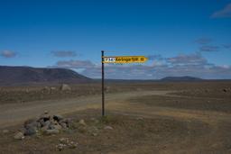
Halfway down the mythical off-road trail, we arrive at the intersection with the F347, which leads to Kerlingarjöll after about 10 km. There is no ford on the road, and it's a very easygoing drive.
Hveradalir and its hikes

You then quickly arrive at the main campsite of Kerlingarfjöll: Ásgarður.
The Hveradalir hike is without a doubt the most famous of the Kerlingarjöll mountain trails. There are many hikes here, and there is plenty of information at the shelter near the car park, trail maps and how they can be combined. Hveradalir is hiking trail number 2.
There are several hiking trails to explore Hveradalir, but two are particularly well-known:
- The trail starting from the Ásgarður parking area (more challenging, approximately 4 hours)
- The Hveradalir Circle hike, developed in recent years, which begins from the second parking lot located 5 km further up (moderate level, approximately 1 hour and 30 minutes)
Hveradalir via the hike that starts from the Ásgarður parking lot

After parking in the Ásgarður car park, a small footbridge takes you across a stream to begin a beautiful ascent. You can't miss the large red sign indicating the direction of Hveradalir (straight ahead) and the Kerlingarfjöll Mountains hotpot (on the left). The path is very well-marked, and you really can't get lost on your way up if the weather is clear and visibility is good.
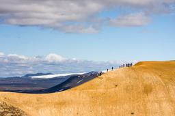
The 6.5 km ascent takes just under 2 hours to reach the Hveradalir site. It's a steep climb from the very start for the first 30 minutes before reaching a plateau. The view from here is already incredible, dominating the campsite shelters below, which seem tiny.
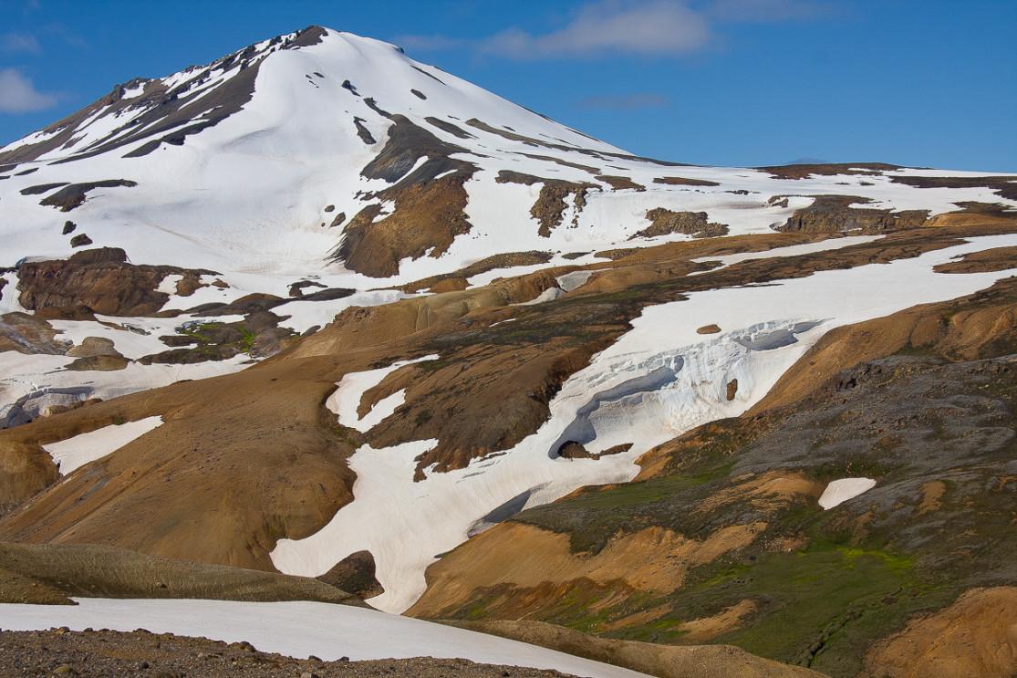
The path continues downhill and then back up along two small mountain slopes before crossing the névé, the long snow patches that never melt. Indeed, the Kerlingarfjöll mountains are still snowy at altitude even in summer, being more than 1000 m from sea level.

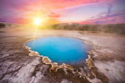
From here the landscape changes, the lunar and rocky scenery gives way to magnificent ocher colors. These reddish hues are typical of the region, the ochre slopes of the mountains contrasting perfectly with the white of the snow and the green of the moss. This color is characteristic of rhyolite, which is the main mineral present here.
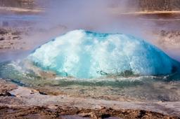
We then arrive at a plateau which involves crossing a few tens of meters of firns. This is when the first fumes begin to appear in the distance, and the smell of sulfur carries faintly on the wind. By the end of the plateau, the smell is everywhere, and an ominous sign indicates the volcano 1.1 km away.
When you get there, the beauty of the scenery is simply breathtaking, a true 360° panoramic view with fumaroles everywhere pouring mist into the sky. The orange-red rock in good weather give the site the appearance of a landscape painting, the very definition of picturesque. It can get slippery with mud so it's best to avoid getting too close to the edge because here, you really are looking down the barrel into the fumaroles. This is without a doubt one of the most spectacular sites in the country.
If you squint, you'll see tourists on the horizon walking the slopes of Hveradalir, and your brain will click with a sense of scale and take in the immensity of the site.

You go back the way you came, but this goes much faster being completely downhill, so it only takes 1 hour and 40 minutes to reach the car park by heading towards Asgardur.
In total, this hike will take about 4 hours including a bit of time to admire the site and complete the 12-13 km walk. If you still have energy by the end, many tourists branch off just before the campsite to head towards the Kerlingarfjöll hotpot.
With the time needed to arrive via Kjölur, the trip to Kerlingarfjöll takes up a full day during the stay but is definitely worth it, especially in nice weather. Even more than elsewhere, it is strongly recommended to find out about the weather conditions before going on a hike in Kerlingarfjöll, especially as the weather changes quickly in the mountains.
Hveradalir via the Hveradalir Circle hike

The second option is to stop at the second parking lot, located about 5 km further north from Ásgarður, along a small, rough gravel road.
This hike is much shorter and forms a loop between Hveradalir and Snorrahver, skirting the slopes of Mænir, which rises to 1,335 meters. The views here are breathtaking, and the trail, now very well maintained, is accessible to everyone, with small steps installed on the steeper sections.
The wind can be extremely strong in this area, so caution is advised, as some sections can be a bit trickier under certain conditions.

Be warned though: the wind can be absolutely fierce here, turning some sections into a thrilling challenge! A short snowfield crossing — about fifty meters — adds a touch of adventure to the hike, but overall, the path remains manageable and rewarding at every turn.
The landscapes here are pure magic, culminating in an unforgettable arrival above the steaming vents of Hveradalir. Colors shift from vibrant reds to soft yellows and dazzling whites, creating one of the most surreal panoramas you can imagine.
If you had to choose just one hike, we would definitely recommend the Hveradalir Circle. It’s a little gem — more accessible for families and casual hikers, yet still offering some of the most stunning scenery you’ll find anywhere in Iceland.