Kerlingarfjöll hiking guide

Lost in the heart of Iceland, Kerlingarfjöll, literally: “the mountains of the good woman”, is a very active geothermal site.
It is a remote mountain range in central Iceland that offers unforgettable hikes.
The highest point in this mountain range is Mount Snaekollur (1488 m). Kerlingarfjöll is part of the rift zone in the Atlantic Ridge that crosses Iceland from south-east to north-west and belongs to a volcanic network that stretches 100 km².
- Kerlingarfjöll: one of the most beautiful sites in Iceland
- How to get to Kerlingarfjoll?
- Kerlingarfjöll hikes
- When to get there?
- Where to sleep?
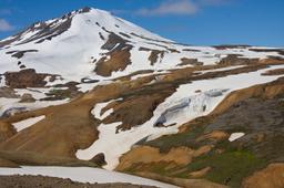
Kerlingarfjöll: one of the most beautiful sites in Iceland

Kerlingarfjöll and its contrasts, near the second car park
The particularity of Kerlingarfjöll is the orange color of its flanks, which comes from the rhyolitic stone that makes up the vast majority of this mountain.
Not being located along Road number 1, you won't find that many tourists in Kerlingarfjoll, yet it is one of the two or three most beautiful sites in the country. Any visitor who goes to Kerlingarfjöll is struck by the chromatic harmony, almost a painted composition with the flame-coloured mountains contrasted by the snow, especially on a clear day.
Like the Landmannalaugar region, the Kerlingarfjöll region is renowned for its incredible landscapes and panoramas and is a must for all hiking enthusiasts.
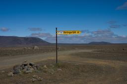
How to get to Kerlingarfjöll?
Though it is possible to reach Kerlingarfjöll via the F347 east and the F26, the easiest and most convenient way to get there is to get there from the south or from the north via the Kjölur trail: number 35. Generally, after spending the night near the Golden Circle, visitors leave the next morning to visit the Kerlingarfjöll Mountains, as the Golden Circle connects to off-road trail 35.
4x4 journey via Trail 35, then F347

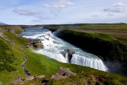
Starting from Gullfoss, take the Kjölur red stone road for about an hour until the next junction, driving past the beautiful Hvitarvatn lake. It's a bumpy ride, very much so in fact, with deserted landscapes that bring to mind the red planet Mars.
From the crossroads mentioned above you have two options: continue straight on the 35 towards Blonduos via the oasis of Hveravellir for about 30 km from here, or branch off onto the F347. The F347 track is now in much better condition than it used to be and above all, there is no need to cross a ford anymore. After a short quarter of an hour on the trail (10 km), you will see Gýgjarfoss, a small waterfall that is worth at least a quick stop.
A few kilometers away, you'll find the first car park for the Kerlingarfjöll site, complete with chalets and a sign leading to Asgarðsfjall.
In the end, the track that leads to Kerlingarfjöll is quite easy and although you'll need a 4x4 vehicle (for the off-road trail F347), it's not a particularly challenging drive.
By bus
The site is also accessible by bus. Indeed, SBA line 610 takes you from the capital via Gullfoss, Kjolur and Kerlingarfjöll to finally reach Akureyri.
For additional information, consult the website http://www.publictransport.is/ or our article on buses in Iceland.
Guided tours

The superb reliefs of Kerlingarfjöll
From Akureyri you can of course book a tour to be taken by jeep to Hveravellir and Kerlingarfjöll.
Where to park?
In fact, there are two parking lots in Kerlingarfjöll where you can park and strike out on foot for the hiking trail. Look for the green and red huts easily recognized from afar which point you to the main car park, the location named Neðri-Hveradalir.
The second car park is slightly higher up the trail. Pass the huts for about 4.5 km on the bumpy track to the small car park at the Kastali hut.
The choice of parking depends on your hiking skills and what you plan to do (see below). Neðri-Hveradalir is the main car park from which the majority of hikers leave.
Kerlingarfjöll hikes
As soon as you arrive on site, you'll realize the place is big, in fact immense and worth every drop of sweat as it is truly magnificent, the color contrasts simply magical. The flaming orange-yellow rhyolite hills contrast with the bright green grass and white streaks of snow, add to that the fumaroles and solfatars, with all around you the pungent smell of sulfur, and you have one of the most magical places in Iceland.
Perhaps the most impressive thing is when you get a sense of scale seeing the size of the hikers in the distance walkers compared to the majestic mountains. If you have the chance to visit with good weather, the sunlight hitting the orange flanks is a spectacle unlike any other.
Hikes everywhere

Kerlingarfjöll hiking map
There are so many hiking trails in Kerlingarfjöll, almost twenty. Some will take you on a complete ascent of the Fannborg and Snaekollur mountains, with a splendid view of all of Central Iceland from the peak.
The map of possible hiking trails is posted in the image above. Depending on the car park you choose (Neðri-Hveradalir or the Kastali hut), the site offers enough hiking options for every taste.
You are sure to find exactly what you want, from a 1-hour leisurely hike to a full 3-day marathon! All official hikes are listed on the official website http://www.kerlingarfjoll.is.
The Hveradalir hike

The best known hike in Kerlingarfjöll is without a doubt the Hveradalir trail and we highly recommend it. This hike is detailed in our dedicated article about this hike. Its 6.5 km will take you at least 2 hours to reach the Hveradalir site (one way only) with a significant elevation factor. This hike starts from the main car park in Neðri-Hveradalir and offers absolutely breathtaking landscapes!
The Austurfjöll hike
This walk starts from the Kastali hut, the second parking lot, and takes you to the steep slopes of Lodmundur and Fannborg. The ascent continues until you reach the summit of Snaekollur at 1428 m. The walk is 7 km long, and you have to count 5h30 to complete the whole loop.
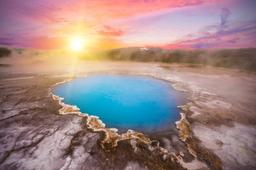
Swim in a hot spring!
As promised, this is your reward for all the effort. Kerlingarfjöll is an important geothermal area, and this often means hot springs nearby.
Very close to the campsite, hike up the Hveradalir for less than 1 km to find a gorgeous stone pond.
A sign indicates a hotpot just to the left in the Asgarður Gorge. The pool can accommodate a dozen people and the water temperature is approximately 36-38 °C.
When to go there?

Neðri-Hveradalir huts in Kerlingarfjöll
Summer between mid-June and early September is the ideal period.
As strange as it may seem, the site is open all year round in winter and summer. Although it is clearly in summer that the contrasts and colors of the place exude the most magic, some visitors go there outside of summer for a bit of peace and quiet.
However, you should know that in winter, the site is very difficult to get to or even impossible and generally, from October to May, the region is covered in snow.
Sleep in Kerlingarfjöll

The first parking lot and the huts of Neðri-Hveradalir in Kerlingarfjöll
Neðri-Hveradalir, with the red and green huts mentioned previously, is next to the Kerlingarfjöll Mountains camp site, which has its official website http://www.kerlingarfjoll.is. It is the only place to sleep in the entire region.
The place is very well-equipped and has a restaurant that serves breakfast, as well as a building with an equipped kitchen.
Recently, the site has expanded to include a new building with no less than 20 double rooms with very modern private bathrooms. In addition, there are also 10 small independent chalets, and another chalet where you can lay out your sleeping bag for a budget option.
Very close to the huts, you can even to pitch your tent on a large camping ground. A former ski resort dating back to 1991, only the chalets remain open today.
The place is very popular, obviously since it is the only place to sleep for miles in every direction, so you'll need to book as early as humanly possible.
Our opinion

Kerlingarfjöll color palettes
The Kerlingarfjöll site is most definitely remote, requiring quite the expedition to ge there, but it really a little slice of paradise that offers absolutely incredible view you won't see anywhere else.
There are so many absolutely stunning hiking trails that it would be a shame not to go there. Being located along Route 35, it is also a convenient mid-point on any journey from the south to the north, such as visitors leaving the Golden Circle to go to Lake Myvatn or Akureyri.