The Eldfell Volcano and Hiking Trail

The Westman Islands form an archipelago off the south coast of Iceland. All the islands are uninhabited except the main one, Heimaey, with its population of 4,142 inhabitants.
The history of the Westman Islands has been scarred by several eruptions, the last of which, Eldfell, was particularly tragic in 1973.
The Eldfell Volcano Eruption of 1973
From January 23 to June 28, 1973, for nearly 5 months, the volcano projected enough slag and lava to enlarge the surface of the island by nearly 2.5 km². In the early days of the eruption, Eldfell's lava output was reaching an impressive flow of 100 cubic meters per second.
The eruption caused only one death, but nearly 300 homes were destroyed and 70 more were bombarded by scalding tephras. Almost all the island's inhabitants had to be evacuated.
By the end of the eruption, on 28 June 1973, the lava field spread out over 3.3 km² and it was not until July that the inhabitants were finally able to return to the small island of Heimaey to begin the long and arduous work of rebuilding their homes.
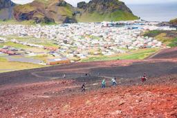
Today, the volcanic cone of Eldfell is the first thing you notice when you arrive on the island. Eldfell is located to the east of Heimaey Island. It's looks out over the Atlantic Ocean with Helgafell, another volcano, to the southwest and the town of Heimaey to the northwest.
Eldfell: one of the most beautiful hikes in Iceland

The Eldfell hike on Heimaey Island in the Westman islands
- A/R: 1.8 km – Time: 1H15 - see hiking map
In recent years, Eldfell has become the main attraction of the island. A scenic hiking trail allows you to climb to the summit for a fantastic panoramic view.
There are two paths to reach the top. If you are driving, which would be preferable, you can park at the Volcanism Museum located at the foot of Eldfell very close to Helgafell.
From here, take the main road but on foot this time, striking out towards the 2 very obvious volcanic cones. A crossroads will give you the choice to turn left, skirting the foot of the Eldfell on your right, or go around the other way to walk straight between the two volcanoes.

The summit of Eldfell
We recommend taking the road most travelled this time, but in any case the two paths converge after 20–30 minutes of climbing. The path that goes straight between the 2 volcanoes gives you a nice view of both flanks rising on either side, and it's the easiest to climb.
After about twenty minutes you get to a first small plateau with a great view of Heimaey from a magnificent perspective, but the real prize is at the top of Eldfell (221 m above sea level) for a panoramic view of the ocean, the island, and the mainland's frigid shores in the distance.
The trail cuts across the volcanic cone with increasingly contrasting red and black of ash and pumice all the way to the summit. The last 300 meters are quite steep and slippery in places, but the view at the top is worth every drop of sweat. From here the town of Heimaey and its typical colorful houses are laid out in minature, and one is humbled seeing the scar left by Eldfell running all the way to the sea and the neighboring Helgafell.
It takes 45 minutes to 1 hour to climb to the top at a leasurely pace, but a little less than 30 minutes to go back down with gravity on your side.
The hike is a bit steep but not particularly difficult. In any case, it is not dangerous and is really the whole reason for visiting this remote island. When you get to the top the colors of the landscape around you, with a view from horizon to horizon, will take your breath away.

The summit of Eldfell and the view of Heimaey