6°


 07 May 2023
The Sjonarnipa-Sjonarsker Hiking Trail

Of the innumerable hikes offered in Skaftafell National Park, the most popular are those that take you to Svartifoss and the breathtaking viewpoints of Sjonarnipa and Sjonarsker.
There are actually several official hiking trails that lead to each of these sites:
- The S2 leads to Svartifoss and Sjonarsker
- The S6 leads to Sjonarnipa
The best way to discover the park, if you have the physical fitness for it of course, is to combine two hikes for a showcase of the best the Skaftafell Park has to offer.
Here is an overview (in yellow) of the trail.

The views are absolutely fantastic, and it's not hard to see why it's one of the most popular hikes in Iceland. It takes 2.5 to 3 hours to complete this loop starting from the campsite. The hike is relatively easygoing, but there is a steady elevation in the early stages, and it's much longer than the Svartifoss trail (S2) since it is about 8.5 km long.
- Distances and difficulty according to the national park
- Parking and services at the trailhead
- Sjonarnipa: a spectacular view
- Svartifoss, Sjonarsker and Sel
- Trail conditions and gear
Distances and difficulty according to the national park
Vatnajökull National Park gives different figures for the official trails than for the loop described here, which is a custom combination of those trails. Keep them in mind so you don't underestimate the effort:
- S2 (Svartifoss - Sjónarsker - Sel): 5.8 km, about 2 hours, rated easy
- S5 (Sjónarnípa): 6.5 km, 2 to 2.5 hours, rated challenging, 320 m of elevation
- S6 (Svartifoss - Sjónarnípa): 7.1 km, 2.5 to 3 hours, rated challenging, 310 m of elevation
The official starting point is in front of the Skaftafellsstofa visitor centre. For the S6, the park advises following the Svartifoss trail and ignoring the first signpost pointing right to Sjónarnípa, then reaching Sjónarnípa from the viewpoint above Svartifoss and returning via Austurbrekkur. If the full loop sounds too long, the S2 or the S6 on its own are shorter alternatives.
Parking and services at the trailhead
The hike starts at the Skaftafellsstofa visitor centre, which is open year-round. Rangers can advise on the trails and current conditions, and toilets are available on site.
Parking is paid. According to the national park's price list, the regional fee is 1,110 ISK for a passenger car with 5 seats or fewer (450 ISK for a motorcycle). It is valid until midnight on the day you pay, and you can drive in and out freely during that time. You can pay at the machines in the car park or online via Parka, as licence plates are photographed on entry. A 50% discount applies if you have already paid for another fee-based area of the park on the same day, such as Jökulsárlón. For access and accommodation, see our article on Skaftafell Park.
Sjonarnipa: a spectacular view

Time: 2.5 to 3 hours - Loop: 8.5 km
Starting from the campsite, take the red S5/S6 trail for 3 km to reach the Sjonarnipa viewpoint. The trail has some serious elevation, so warm up those calves! You'll go from 90 meters above sea level to 350 meters in altitude near the viewpoint. After that point, the hike is mostly downhill.
The lush Skaftafell ecosystem opens itself up, surprising for such a hostile climate, dominated by blueberry bushes which perfume the air during the walk.
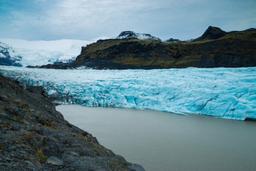
It takes a good 45 minutes to get to the point of view... and it is simply amazing! You are faced with a breathtaking panorama of the immense Skaftafellsjokull glacier tongue, and beyond it the sandurs carved by the rivers flowing to the sea. You can even see Öræfajökull in the distance on a clear day.
Svartifoss, Sjonarsker and Sel

Sel Farm
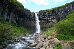
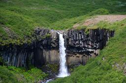
After this transcendent experience connecting with nature, we return to Svartifoss which takes about 30 minutes. The waterfall is undoubtedly one of the most beautiful in Iceland, as you'll see, it is framed by basaltic organs that could have been designed by an artist.
Once you have crossed the footbridge, head towards Sjonarsker, which won't take more than 15 minutes. This is a very popular Skaftafell viewpoint, dominating the region with a magnificent panorama of the Morsardalur valley. The view is exceptional and really gives a sense of scale. When the weather is clear, you can spot icebergs floating in the Morsarsjokull lake.
From here, you have 2 options: finish the loop and go back down to the car park, passing the Hundafoss and Magnusarfoss waterfalls in particular, or if you have the courage to continue a little west to Sel, this will add about 30 minutes to the hike.
Skaftafell was initially a major farming operation, and its ruins are still visible near Eystragil. The buildings were moved in the 1830s and 1850s 100 meters away, and a farm was built in Sel that can be visited where, previously, there was only a sheepfold (see photo).
Trail conditions and gear
- The trails combine compacted soil, wooden footbridges and stone steps, which become slippery in rain, snow or ice. Hiking shoes with good grip and a waterproof jacket are advisable, even for a short loop.
- In winter, snow and ice change the hike considerably: ask at the Skaftafellsstofa visitor centre which route and equipment suit the day.
- The times given are for summer. Outside the season daylight is limited, so plan to be back before dark and allow extra time.
- In spring and early summer many birds nest along the trail, so take care not to disturb them.
- Stay on the marked footbridges and paths around Svartifoss, as the ravine is a protected site.