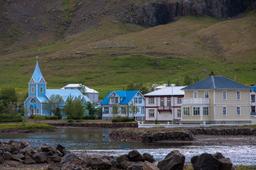
The Borgarfjörður Eystri Fjord (Bakkagerði)
Road 94, in eastern Iceland, in Egilsstaðir, takes you north to the remote Borgarfjörður Eystri fjord. Egilsstaðir is more than 75 km from this fjord, and in fact, the long and winding road is up the nearby mountains is a rather bumpy one.
Borgarfjörður Eystri: one of the most beautiful fjords in Iceland
Frequently forgotten by tourists because of its remote access (150 km detour to/from Egilsstaðir), this fjord is nevertheless one of the most beautiful on the whole island, famously featured on the EDEN (European Destination of Excellence) list since 2012, so you know it's the real deal.
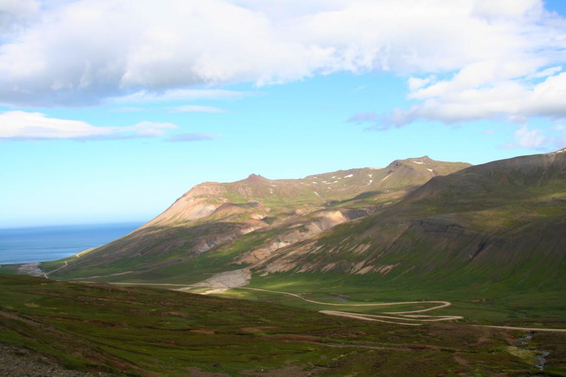
Surrounded by the splendid Dyrfjöll Mountains, which rise to 1136 m, and the superb rhyolites and liparites of Hvitserkur, the place a hiker's paradise. The fjord itself is very beautiful and the panoramas are simply unforgettable.
A hiker's paradise

At the tourist office in Egilsstaðir or Bakkagerði, you can also get a very good map of hiking in the region. Many of them leave from Bakkagerði or very close by.
Some are short hikes, just a few hours, while others are multi-day treks, such as the one at Víknaslóðir which goes from the Seyðisfjorður fjörd to Bakkagerði in 3 days (70 km):
- Borgarfjördur - Breiðuvík
- Breiðuvík - Húsavík - Loðmundarfjörður
- Loðmundarfjörður - Seyðisfjörður
- Additional information about Víknaslóðir
For tourists with only a few hours to burn, one of the most enjoyable hikes in the region is probably Hvituhnjukur. This trail is no longer than 2H30 - 3H. You have to take the F946 track for about 2 km to find the departure point at the car park (listed as hike number 10).
After less than 30 minutes of walking you arrive at the beautiful Urðarhòlarvatn lake, just follow the signposts. Further on, the surprising ridge of Hvituhnjukur rises with its stone flanks.
The path then leaves the stream, so you have to go north-east to find a possible ascent, here it is rather poorly indicated. Once at the summit, you will have the chance to admire an exceptional view of Breiòavik Bay, the hike then makes a loop that allows you to go back down to Lake Urðarhòlarvatn.
Another very fun hike to do from Borgarfjordur Eystri is the trail to Brunavik Bay. On the road leading to the Bakkagerdi port, a small car park and a sign indicate the start of the hike. The path is marked with yellow pegs and climbs for 1H towards the Brunavikurskarð pass.
The path passes between the two mountains named Granipa and Geitfell, and from the summit the view over the fjord is simply magnificent in good weather. The path then goes back down to Brunavik in 30 minutes. The return is via the same path and it takes a total of 3 hours to make the trip back and forth between mountains, fjords and green meadows.
Finally, very close to Bakkagerði, the Storurð trail is a must-see in the region.
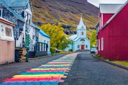
Things to see in Bakkargerdi

In addition to the ocher and pink rhyolites that give the fjord its famous contrasts, photographers will be delighted to see that Bakkagerði is also home to an adorably photogenic puffin colony on the edge of its cliffs.
To see them, you have to go to the end of the road where there is a staircase that leads to the shelf above the port of Borgarfjordur. From here puffins can be observed up close.
The region and its cliffs are also ideal places to observe the midnight sun. The magical twilight produces surprising colors and contrasts along the rhyolite mountain flanks, and lighting up the colorful roofs of Bakkagerði's houses.
At the end of the day one has to enjoy a break in the very original and superbly decorated Alfa Café, which offers particularly delicious Icelandic cakes. The “Álfa Café” is decorated with stones, in reference to the “Elf Rock”, Borgarfjörður Eystri, home to the queen of the Icelandic elves resides according to local legend!