The Stórurð (Storurd) Hiking Trails
The eastern fjords of Iceland are famous for their hiking trails, and the ones that lead to Stórurð are some of the most beautiful in the region.
Stórurð, the “Giant Boulders”, is an exceptional site at the foot of the majestic Dyrfjöll mountain range, very close to the small fjord of Borgarfjörður Eystri.
- Stórurð and its origins
- When to go and how to get there
- The various hikes that lead to Storurð
- The hike from Vatnsskarðsvegur
- Accommodation near Stórurð
Stórurð and its origins

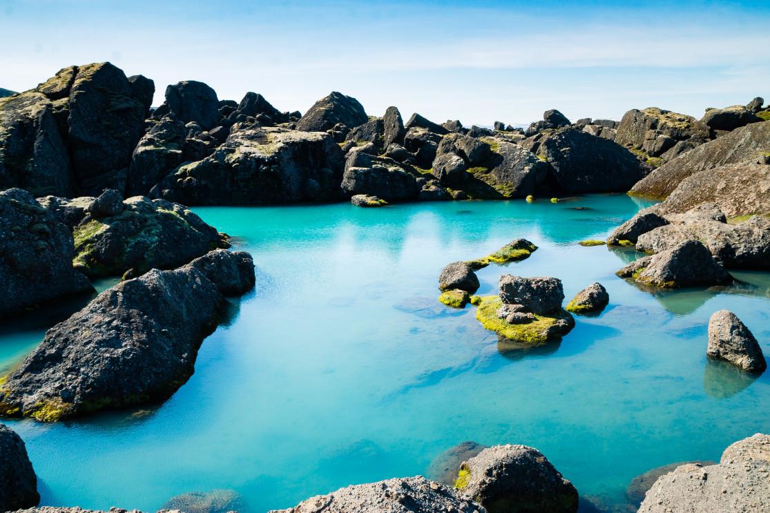
The scree of Stórurð
Stórurð literally means “big wreckage”, but the name doesn't do it justice. The site is an oasis of turquoise pools in green meadows dotted with impressive boulders, with the steep flanks of the Dyrfjöll mountains in the background.
It was formed at the end of the last ice age, and its huge rolling stones were probably carried by the ice left here as the glaciers receded.
The several peaks in the Dyrfjöll range are as follows:
- Mount Súlur, 768 meters above sea level
- Mount Dyrfjallstindur, 1025 meters
- Mount Súla, 1136 meters
This remote landscape in the middle of the Urdardalur valley, with these snowy peaks reflected in the turquoise waters, is quite a sight. Storurð is without a doubt one of the unknown jewels of the eastern Fjords.
When to go and how to get there
This is the perfect place for hiking in summer with nice weather. The warmer months will bring out all the contrasts that make this place so special, and the trails are dry and easygoing rather than muddy underfoot. The trails are very well-marked and not very crowded.
We recommend June to August, regardless of the trail you choose to reach Storurd (see below). And clear skies really are the best conditions to enjoy the panoramic views from this peak.
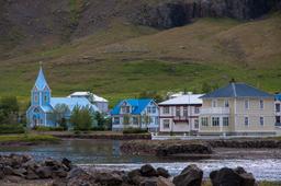
You'll find this little slice of heaven near Borgarfjörður Eystri in the Eastern Fjords. From Egilsstaðir, the crossroads of the Eastern Fjords, take route 94 north to Borgarfjörður Eystri, about 1 hour's drive and 70 km away.
You don't actually have to go through the village, as the car parks serving the hiking trails are located before you get there along Road 94...
The various hikes that lead to Storurd

The 3 main hiking routes to Stórurð
There are 5 official hiking trails in Viknaslodir that lead to Stórurð, numbered: 8, 9, 10, 13 and 14. Trail 13 starts in Bakkagerði (Borgarfjörður Eystri) and takes no less than 11.5 km to reach Stórurð, and that's just one way.
The 3 most popular trails to reach Stórurð are the 8, 9, and 10, marked in red on the map above. Keep in mind that each departs from a different car park. Some hikers choose to take one of the trails on the way there and another on the way back, but this has a serious disadvantage as you'll have to return to your car park via route 94, and they are quite far apart.
The 3 main trails to Stórurð
The 3 car parks are very easy to find, as indicated on the map above. They can accommodate a few dozen cars and are located right on road 94. These car parks are dedicated to the hike, so you will find information and directions posted there.
- Njarðvík (number 10 on the map above): 4.5 km or 2 hours one way
Considered by many to be the most beautiful trail to Storurð, it is also the shortest and most picturesque, but also the most technical. This trail takes you between the Súla and Súlur mountains, right through the heart of the Mjóidalur valley.
So this is a high-level hike with a few rivers to cross, and you need to be well-equipped and well-prepared to handle this safely. The elevation is significant, some sections are literally swampy, and there are unavoidable river crossings towards the end of the journey.
- Vatnsskarð (number 9 on the map above): 7.5 km or 2.5 hours one way
This trail is steep right from the start, and it is also the longest, but the views over the coves of the fjord make it worth every drop of sweat. This trail takes you to the west of Mount Súlur and is like the previous one reserved for experienced hikers.
- Vatnsskarðsvegur (number 8 on the map above): 7.1 km one way (2 hours one way)
This is the easiest trail of the 3, with almost no elevation, running along the foot of Mount Súlur through lush green meadows. This is the family-friendly option that we will focus on.
The hike from Vatnsskarðsvegur

The hike from Vatnsskarðsvegur is accessible to everyone
The Vatnsskarðsvegur car park is the westernmost car park of the 3, if you are driving from Bakkagerði to Egilsstaðir, this is the first you'll come across.
Once you are parked and your boots are laced, you begin the trail going southwest to bypass Mount Súlur along the Rjupnafell. The hike is perfectly marked by yellow pegs and the path is quite obvious, it would be hard to get lost.
You'll be crossing lush green meadows dotted with small ponds and waterfalls. This part of the trail has almost no elevation at all. The second part of the hike takes you east and across a number of streams (very easy to cross without getting your feet wet).

This second part of the hike is where you'll feel a bit of elevation in the middle of the meadows, while the Dyrfjöll range and its snowy peaks start to be clearly visible. This gentle elevation continues as you get closer to the Stórurð Circus.

The Stórurð loop at the foot of the Dyrfjöll
This sign standing in the middle of nowhere explains that the trail loops approximately 1.5 km around the Stórurð rock formation. You can go right or left, but whichever one you choose, if you keep going you'll come back to this fork in the road that leads to your car park.
The right hand trail will have you climbing some of these giant boulders until you reach a plateau where you'll see small ponds surrounded by the famous Stórurð boulders.

Keep going down this trail to reach the main ponds, with their turquoise waters which, when the weather is clear, will reflect the mountain peaks.
The view is truly exceptional, and hikers often stop to relax around these small mountain lakes and enjoy a picnic before heading back to the car.

The beautiful ponds of Stórurð
As mentioned previous, some hikers take one trail to the Stórurð loop but choose a different route back, such as the Vatnsskarð trail for example.
If you are coming back via the same Vatnsskarðsvegur trail you took there, you're looking at 7.1 km, plus the 1.5 km loop, and 7.1 km back, which adds up to about 16 km. It's not at all difficult terrain and the landscape is phenomenal.
For the whole hike you can estimate about 5 hours, the walk there and back with a picnic break in between.
Accommodation near Stórurð

For camping enthusiasts, you're in luck! You will find one very close to Stórurð in the Borgarfjörður Eystri Fjord, in the village itself, known as the Borgarfjörður Eystri Campsite. It has a good reputation, spacious and located only 700 meters from the village.
Below are some other options located very close to Stórurð, in Bakkagerði itself:
The Blabjorg Guesthouse have great amenities including thermal hotpots, saunas, and an amazing breakfast. Both sites are located in the center of Bakkagerði.