6°


 22 November 2020
The Rauðholar Hiking Trail

Jökulsárgljúfur National Park is located in northwest Iceland, a little north of the famous Dettifoss waterfall, the most powerful waterfall in Europe. This nature reserve is a true delight for hikers, home to the Rauðholar and Hljoðaklettar trails, which are known throughout the country and cut through some stunning landscapes.
How to get to Rauðholar
You'll have to take Road 862 coming from the north, via Asbyrgi and its famous canyon, or from the south exiting Road number 1 shortly after Myvatn on the way to Dettifoss.
The 862 up to Dettifoss is in excellent condition and is even paved, but later becomes an off-road trail as it nears the 85 and Asbyrgi. The trail then gets quite rugged and very sandy, but it can be overcome with a bit of technique.
Even though the road is fairly easygoing, keep in mind that the 862 (especially the north) only has limited winter service and can be closed at short notice depending on the weather, however confident you may feel that day. Check road.is (Vegagerðin) before setting off.
- Here is a detailed map of the national park
Raudholar: A hiking trail to remember

The hike starts from the Vesturdalur car park. The trail is very well-marked, but the national park rates it as “challenging”, so approach it with caution, especially with children. You need 1.5-2 hours to complete the 5 km loop, which has some elevation gain (less than 150 m).
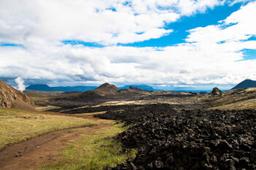
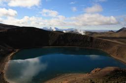
The trail takes you through truly lunar landscapes: large volcanic vents and other basalt columns formed by the slow cooling of lava over time rise around you. The Hljoðaklettarhingur hike is the natural continuation, a lava field like a sculpture gallery of incredible basaltic formations.
The name Hljóðaklettar means “the echo rocks”: the many caves and rock formations make sounds resonate in surprising ways. Hljóðaklettar and Rauðhólar are part of a row of craters roughly 6 km long that erupted around 8,000 to 9,000 years ago. Most of them originally looked like Rauðhólar, but during violent floods the Jökulsá river swept away the loose material and left only the inner structure of the craters, which is what you see at Hljóðaklettar.

This is when you get to see one of the main attractions, the Kirkjan (church) of Hjoðaklettar, a unique cave-shaped formation. This lava flow rose as immense pressure gathered beneath it and formed this very impressive cave that visitors love to photograph.
Keep going towards Rauðholar as it rises in your field of vision with stunning contrasts. The effect is incredible, the red and black flanks of the volcano clashing with bright green moss. The reddish slag that paints the flanks is what gave the mountain the name Rauðholar.
From the top, you can enjoy a panoramic view that includes the Jökulsa Gorge and the forests around Asbyrgi. This hike is like a geology lesson, offering the chance to observe a wide variety of geological phenomena.
Near the summit, it can get very windy, so be careful once you get there. The trail cuts straight for the car park on the way back.
There is an extension to the trail, adding 30-40 minutes to see the two famous Karl and Kerling rock formations, “The Man and the Witch”, basaltic pillars said to have been trolls in the past.
This second hike starts from the car park you arrived at and offers a breathtaking view of the canyon.
What to see nearby
The hike combines easily with the other stops in the park: Dettifoss for the sheer power of the waterfall, and Asbyrgi canyon for a calmer, wooded canyon floor. The park's information centre, Gljúfrastofa, is located at Ásbyrgi. For an overview of the whole area, see our guide to Jökulsárgljúfur National Park.