10°


 29 March 2019
Asbyrgi Canyon

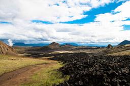
Asbyrgi Canyon is one of Iceland's most dramatic natural landmarks, a relatively grand canyon in the heart of abundant vegetation.
Located in the North, in Jokulsargljufur, this canyon is 3.5 km long and 1 km wide, built by the Jökulsá á Fjöllum to create a natural arena in the shape of a horseshoe. The canyon was formed when a huge earthquake caused the diversion and disappearance of a major glacial river (see below for the glacial flood explanation).
According to legend, this horseshoe shape is an imprint of Odin's gigantic divine horse.
Asbyrgi is part of the Vatnajokull National Park and a detailed map of the park is available here: map of Asbyrgi.
The beautiful hiking trails of Asbyrgi

Asbyrgi: estivillml @fotolia
As you can see on the map there are two car parks in Asbyrgi: the first near the information center where the Eyjan hiking trails begin, and the second near the Botnstjörn pond.
There are no less than 10 official hiking trails in the park. One of the best known leads to the main Asbyrgi viewpoint. Directly behind the car park information center is a small, marked path and, after climbing the rocks on the left, simply continue south to the tip of the rocky island. The return trip (4.5 km) takes about 1.5 to 2 hours with very little elevation.
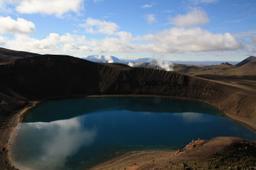
Another hiking trail takes us to the small Botnstjörn lake in 45 minutes and back. The trail departs from the same car park and starts via the elevated platform, then across stone steps to the small Botnstjörn pond. There is also a nice view of the pond from the platform located under the western cliff of the canyon. A stone staircase will take you from the platform to a small hill, where the view of the canyon is magnificent.
Hiking trails abound, referenced 1H to 7H, and there is a hike for everyone. Many hikers take the trail to Asbyrgi before continuing to Jökulsargljúfur Park, or there's the trail from Asbyrgi to Hljòðaklettar. One of the most legendary is from Asbyrgi to Dettifoss totalling 32 km over 2 days!
Asbyrgi - Dettifoss

This is a 2-day hike, so it's not for the faint of heart, but it's one of the most famous for good reason. This hike is magic for the diversity of landscapes it crosses. It starts from the Asbyrgi Gorge with its lush vegetation, passing by lovely lagoons, and ending with the deserts around the famous waterfall. (PDF of the hiking trail)
Total distance: 32 km
- Ásbyrgi - Vesturdalur: 12 km
- Vesturdalur - Hólmatungur: 8 km
- Hólmatungur - Dettifoss (along Hafragil): 11.5 km
Since the hike takes two days, tourists usually stop at Hljóðaklettar (Vesturdalur) for an overnight stay. Hikers will stop here and turn around the next day or finish the hike to Dettifoss waterfall. Vesturdalur has a fully equipped campsite, so you can rest easy.
The first stage departs from the visitor center, after which you turn south at the junction located east of the golf course. At this point, the path goes uphill until you climb a cliff. Then you go south to Klappir and Kvíar.
It's 8 km from Vesturdalur to Hólmatungur, and there's a river to cross on foot, the “Stallá”, which shallow as it may be remains freezing cold so bring extra socks! From Hólmatungur you'll have to cover the final 11.5 km to reach Dettifoss on the last day.
The hike is not too technical, though there are two ways up onto the canyon rim near Asbyrgi: the easier one passes east of the golf course, while the harder variant, due south of the visitor center, is climbed with the help of a rope fixed to the cliff (not recommended with a heavy pack). Most hikers will do a one-way trip from Ásbyrgi to Dettifoss, admire the magnificent waterfall, then take a bus back to their starting point, with bus companies like SBA and Fjallasýn, which offer shuttles on request (check the days and times for the season) between Ásbyrgi, Dettifoss and Húsavík in summer.
- Official site: http://www.vatnajokulsthjodgardur.is
How to get to Asbyrgi
Although quite remote in the far reaches of northern Iceland, Asbyrgi is easily accessible with a traditional vehicle via road 85 that leads from Husavik to Kopasker. It only takes 45 minutes to drive the 60 kilometers that separate Husavik from the Asbyrgi car park.
The sheer cliffs of this natural monument are quite stunning, and this is also a chance to see one of the rare forests in Iceland, a superb stretch of birch, pine, and other mountain ash trees known as Ásbyrgisskógur. Down in the canyon lies a small lake, the “Botnstjörn”, with a rich birdlife and beautiful green waters.
Another useful landmark to know is the huge rock right at the entrance to Asbyrgi, about 25 meters high and 500 meters long, called “Eyjan” which means “island” in Icelandic.