Thingvellir National Park
Located 50 km east of Reykjavík, Thingvellir (Thingvellir) is one of Iceland's most well known sites and a must-see for visitors. This national park covers 237 km² with both geological and historical points of interest.
Thingvellir National Park was listed on the UNESCO World Heritage List in 2004. It is one of the three wonders of the Golden Circle with Gullfoss Falls and the Geysir site.
- The history of Thingvellir
- What to see and do in Thingvellir
- When to go and how to get to Thingvellir
The history of Thingvellir

This park has a symbolic importance to Icelanders, and they are very attached to it. Quite simply, this is the most important place in the history of the Icelandic nation.
This naturally-formed arena, an amphitheatre even, was the birthplace of the Alþing, considered to be the oldest parliamentary structure in Europe, dated 930.
The leaders of the various clans met on these holy grounds to discuss political key issues and resolve disputes. And it was a court where justice was served. For example, it was here that, in the year 1000, the clans agreed on the Christianization of Iceland.
The parliament remained rooted to its birthplace for centuries until 1798, when it relocated to Reykjavík, the capital. However, to honour these roots it was in Thingvellir that Iceland was declared a Republic on June 17, 1944.
While Thingvellir has all but lost its functional role in the country's politics, the site remains a strong political symbol. National and international festivals and events are regularly held in this historically charged location.
What to see and do in Thingvellir

The Almannagjá Fault in Thingvellir - Alex He @Unsplash
There are various car parks around the park which double as the starting point for many short hikes, but ideally we recommend the P1 car park, which gets you quickly and easily to the main places of interest.
Thingvallavatn lake is the biggest in Thingvellir Park, in fact it's the largest in Iceland. It is also 114 meters deep and, being located between two tectonic plates, is the site of fairly frequent earthquakes.
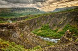
Thingvellir Park also has fascinating geothermal features. Located right on the line between the North American and Eurasian tectonic plates, there is significant seismic activity here, as evidenced by the faults and cracks present throughout the site.
The Thingvellir hike ★★★★

There is a well-known 2-hour hike in the park that allows you to see all the points of interest and is quite user-friendly. It starts from the P1 car park and visitor center. After a stop by the panoramic platform for a beautiful overview, you'll take the path down into the Almannagjá Gorge. The trail then leads past Lögberg, “Rock of the Law”, recognizable by its Icelandic flag, where parliamentary texts were read in the past.
Then, a plank path leads to the beautiful Öxararfoss waterfall and once you've had your fill of admiring the beautiful fall, cut back to the trail which leads towards Skogarkotsvegur. After the man-made pond across Road 361 you'll reach a beautiful birch forest and end with the Skogarkot farm which features a stunning view.
The trail back cuts right through the lava fields to reach the church and car park.
Here you will find a detailed map of the various hiking trails in Thingvellir Park.
Almannagja ★★★

This is what's known as a rift zone and this is clear as day when you see the Almannagjá, a fault line 7.7 km long and 64 m at its widest point that forms a veritable canyon. Each year, the North American and Eurasian tectonic plates grow apart by 2 to 3 cm.
The Almannagja fault starts at the foot of the ancient Ármannsfell volcano and ends underwater in the lakes, forking into multiple crevasses.
Öxararfoss ★★★★

Some faults are conquered by rivers, such as the Öxara, which crosses the entire plain and bottlenecks into the Öxararfoss waterfall when the water reaches the Almannagjá canyon and plunges 20 meters down in a torrent of sound.
There are numerous activities and hiking trails in the park, weaving around faults and volcanic rocks, but some stand above the rest.
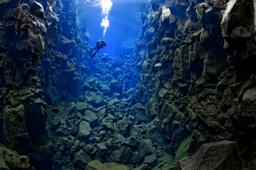
Silfra ★★★★

Silfra diving: nudiblue @fotolia
If you are a fan of diving, for example, you will love Thingvellir. The park is home to the Sifra rift which is one of the top 10 diving sites in the world. The water is clear as glass, with visibility over 100 m, allowing you to observe the bedrock of the actual fault line between Europe and America!
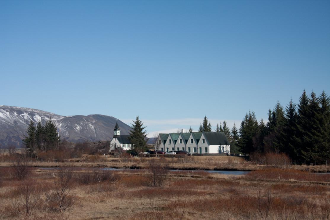
Thingvellir Church ★★★

You can also take a walk to the charming little local church. This magnificent church is open to the public from mid-May to mid-September from 9AM to 5PM.
From a practical point of view, several car parks exist at different points in the park, as well as several campsites and other information centers that indicate hiking trails available. They can also refer you to diving professionals if you want to discover the underwater wonders of Silfra.
How and when to get to Thingvellir?
By car
Easily accessible, you can get there, park, and walk around to your heart's content both in summer and in winter. Following Road 36 from Reykjavik, the park is located less than 45 minutes from the capital, or Road 435 then 360 will get you there from the south.
By bus
Buses take you to the Golden Circle via line 610, but there are no stops inside the park.
Additional information on bus lines: http://www.publictransport.is/
Organized excursions
You should know that organized excursions offer 1/2 or full day Golden Circle tours from Reykjavík. Here are a few examples: