The Hengifoss Waterfall Hiking Trail
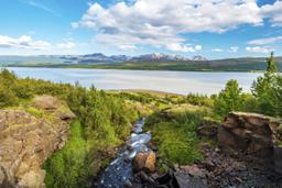
The Hengifoss waterfall is located in east Iceland on the Brekkuselslækur stream, west of the famous Lake Lögurinn and its legendary sea monster, the Lagarfljótsormur.
It is in fact the Hengifossá river that flows into Lake Lögurinn (and the monster's lair).
At 120 m in height, the waterfall is the 3rd highest waterfall in the country, after Glymur and Morsárfoss in Skaftafell Park. This means you can even see it from Road 931 about thirty kilometers from Egilsstadir.
Hengifoss is also considered to be one of the most beautiful waterfalls in the country, and together with Dettifoss, the top ranking falls in the East.
How to get to Hengifoss
Most visitors to Hengifoss pass through the small town of Egilsstaðir. From here, you'll have to take Road 931 heading south along Lake Lagarfljot.
30 km later, as you reach the end of said lake, turn right again on the 931 to cross to the other shore.
Finally, at the end of this road, take the 933 left and the waterfall car park is a few hundred meters further on.
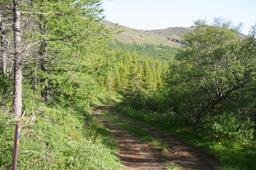
The hike starts from this car park, where you'll see indicated some useful tips for this hike, as it is very often the case in Iceland.
The Hengifoss hiking trail

From the road you might get the impression that the waterfall is only a few steps away, but that trick of perspective is a mirage, and it's a long climb to get there.
From the car park get ready for a short hike and even if it's not very far (about 2.5 km), the elevation is 270 m and the terrain is hilly, so your calves will definitely feel it.
Count about 1H15 to reach the foot of Hengifoss. Some passages are muddy, and you'll have to cross a few small streams to reach it.
From the car park it's very well indicated: a few steps lead to a path that runs along a stream on a green plateau, and you can't miss the huge waterfall.

The trail to Hengifoss is very pleasant, a bucolic scene with grass and flowers all around you.
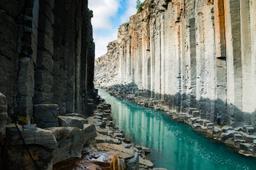
Pit stop at Litlanesfoss
Halfway through (1.2 km from the car park, a 30-minute walk) there is another fall, more modest in scale but still magnificent: Litlanesfoss. The striking basalt columns that surround it were formed by cooling lava.
Litlanesfoss, also called Stuðlabergsfoss, is nearly 30 meters high, and the fall falls cascades over two levels.
You won't believe the sound of water breaking within the basaltic organ, which is essentially an arena. There are small paths down into the canyon to take a closer look, but the descent is slippery, so be extra careful. To reach the main fall from Litlanesfoss, the path gets a bit steeper.
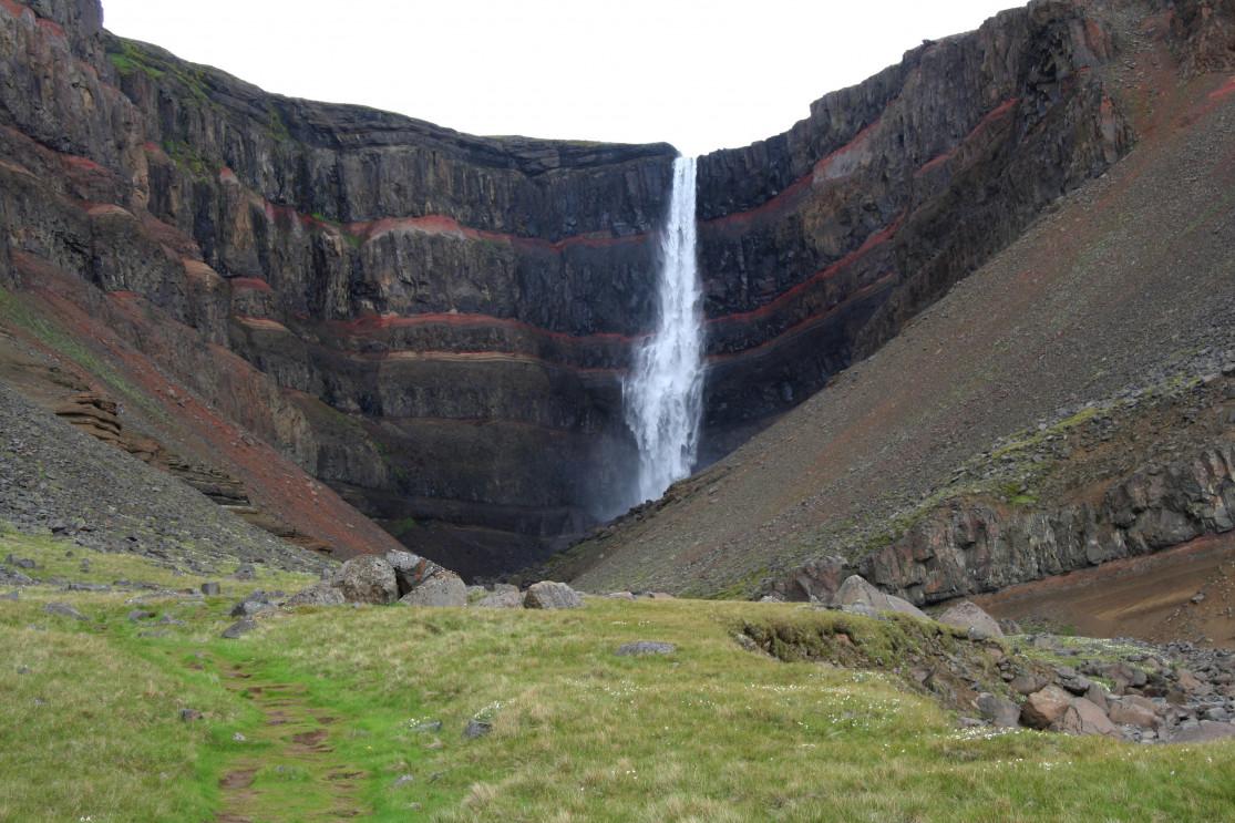
Hengifoss and its red strata

Depending on the time of year, you may have to hike across more or less mountainous areas.
You'll reach Hengifoss 45 minutes after leaving Litlanesfoss. You can get very close to Hengifoss, but it is often windswept so you're bound to get a bit wet! Photographers often find spots a little up the road just before reaching the fall for better views.
The walls have red and black hues that give a magnificent effect to the waterfall, and the red strata are particularly vivid with the bright northern sun in the Icelandic sky.
The Hengifoss waterfall is known especially for these strata of red clay rock sandwiched between layers of basalt. The basaltic strat are 5 to 6 million years old and come from volcanic eruptions in the Tertiary period.
The red bands are in fact sedimentary and the red color is created by the oxidation of iron in clay. Another black and red striped landscape well known in the region is the Strútsfoss waterfall with its hiking trail.
The descent to the car park takes you back the way you came and only takes half an hour of very pleasant walking along the Hengifossa stream.
The view of Lake Logurinn (also called Lagarfljót) on the way down is superb, and the wild landscape is truly peaceful, but keep your wits about you if you run into any Arctic foxes.
In the end, this is a worthy hiking trail which will take about 1H45 to make a return trip for a total of about 5 km.
If you're driving south, it would be a real shame to pass by Hengifoss and its little sister Litlanesfoss without stopping to see its famous red stripes.