10°


 03 April 2015
From Kleifarvatn to the Southern Waterfalls

The alarm went off at 7:30AM and the sky was as clear as ever, boding well for our big day. Today we had planned to visit the parts of the Reykjanes Peninsula that we had never had the opportunity to see: Lake Kleifarvatn and Krisuvik. Then, we planned to drive along the south coast of the peninsula to reach our cottage and see the southern waterfalls in winter and potentially Vik, if we had time.
If you plan to repeat this route in winter, here are a few reminders from safetravel.is:
- front and rear lights must be on at all times, 24/7: in automatic mode the rear lights do not always come on, so walk around the car to check;
- daylight is limited: allow extra travel time and keep your plans flexible, even if it means skipping a stop;
- check the weather on vedur.is and road conditions on umferdin.is: strong wind and drifting snow can make driving dangerous even when the road looks clear;
- make sure your rental car has winter tires: a 4x4 helps, but it does not remove the risk of skidding on ice;
- in an emergency, call 112.
Heading to Reykjanes
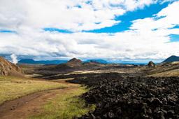
After a hearty breakfast, we headed west to branch off on Road 42 in the direction of the lake. Then, surprise, we did not expect such a superb landscape in winter at all. This road was absolutely magnificent, and arriving near the secluded lake in the middle of nowhere, the panorama was unforgettable: the ocher slopes of the mountains mixed with the snowy skies with the contrast of the blue sky and Kleifarvatn were absolutely remarkable.
We arrived at Lake Kleifarvatn around 10AM and stayed for a long time, admiring the place. We hadn't seen anyone since the junction on Road 42, and we really felt alone in the world with the lake in front of us. Furthermore, we even had the opportunity to see an Arctic fox, all white and too fast for us to have time to take a picture of it. While walking along the lake, we saw a ptarmigan, also white.
Kleifarvatn is the largest lake on the Reykjanes Peninsula: about 9 km² in area and 97 m deep, making it one of Iceland's deepest lakes. No river feeds it; the water seeps in and out through the porous lava rock. An earthquake in 2000 drained more than 20% of its surface area and created hot springs in one corner of the lake. The event inspired Arnaldur Indriðason's crime novel Kleifarvatn (The Draining Lake). According to local folklore, a whale-like monster lives in the lake, a bit like the Loch Ness Monster.
The road to Kleifarvatn

We would have liked to stay longer, but we needed to hit the road. A few kilometers away, a sign said “Seltun,” and this was the famous Krisuvik geothermal zone. Mud pots, smoke, and other sulfur odors reminded us of the Geysir site. We spent almost 1 hour on site, walking between the footbridges of this fantastic site.
For practical details, there is a car park right by the site, the boardwalk loop takes about 30 minutes at an easy pace, and a short hike to Ketilstígur starts from Seltún if you want to stretch your legs further. Whatever you do, stay on the boardwalks: the ground is very hot in places.
To reach road number 1 and its waterfalls, we drove along the coast on road 427. Again, we didn't see many vehicles and decided to have a picnic on the seafront, frozen stiff by the harsh Icelandic winter wind.
Good to know: road 427 passes a few kilometers from the junction with road 42, near the Krysuvikurberg bird cliffs, a worthwhile stop mostly in summer. Also, since November 2023, earthquakes and eruptions near Grindavík have damaged several roads on the peninsula: before following this route, check closures and road conditions on umferdin.is.

At the very beginning of the afternoon, we arrived at the chalet. It was part of a small hamlet of 5-6 chalets with a perfectly unobstructed view, each with a small sheltered hot tub on the terrace. No doubt we would be using it tonight! We set up the luggage and hit the road to Seljalandsfoss.

Here, the grass was rather yellowish and not yet green, and the left part with the staircase that allowed us to approach the waterfall was absolutely impassable because it was covered by a significant thickness of ice. A few tourists were present, but it was incomparable with a month of July or a month of August as we had known.
Farther away, Skogafoss was as impressive as ever, and it too was surrounded by snow, even though it had largely melted since our arrival with the positive temperatures, the sun, and the wind always present.
It was almost 4:00 pm, and after a short snack at the foot of Skogafoss, we decided to take a walk near the beaches of Vik. Vik was one of the villages that marked us during our first 2 trips. We really liked this place and the mountains that surrounded it.
In Vik too, we felt very alone, and the walk on the square was really pleasant. It was less cold, and there was no snow at all in Vik. Probably due to its geographical location, on the coast and in the extreme south of the island. We walked for a long time along the black sand beach with the rough sea a few meters away from us. We had known the area with thousands of birds, but now it wasn't the season, only the sound of the sea and the clicking of the waves broke the silence.
A word of caution: on the black sand beaches of the south coast, especially nearby Reynisfjara, sneaker waves are very dangerous. They surge without warning, much higher and farther up the beach than the previous waves, and can sweep an adult out to sea within seconds. Stay well back from the water, never turn your back on the sea, keep a close eye on children and beware of falling rocks near the cliff. At Reynisfjara, warning lights show the hazard level: yellow (stay alert), orange (stay at least 25 m from the sea) and red (beach closed, views from the designated viewing area only).
At the end of the afternoon, we went to the Vik gas station to buy something to eat at the chalet in the evening. We also took a few Viking beers that we promised to enjoy in the hot tub on the terrace while looking at the mountain in the evening, hoping to see an aurora borealis.
Unfortunately, it wouldn't be this time; the evening was unforgettable, but there were no northern lights in sight. It was time to go to bed to be rested for the next day!