From Landsendi to Þerribjörg via Road 917
Today, we went to the northern part of the Eastern Fjords, a wild and remote region often forgotten by tourists: Fagradalsfjöll.
When we were near Borgarfjörður Eystri and looking north, we could see beautiful golden mountains dominating the large stretch of beach, including Húsey. We'd always wanted to go there, and now was the time!
Road 917 to Landsendi

Road 917, which starts shortly after Egilsstaðir and heads north, is dead flat and in excellent condition even though it is a dirt track. You have to drive nearly 30 kilometers on this road before reaching the twists and turns of Road 917.
This road is beautiful and when you reach the top the view towards the beaches stretching out below is incredible, with the water, the beach, and the bright green grass contrasting magnificently.
Just before these laces, in the foothills essentially, there is a small car park that indicates the first hike, the Landsendi trail.
The Landsendi hiking trail

Landsendi literally means “The End of the Country” and it is true that we are at the end of the peninsula here. The hike starts with a small path that starts along the sea and you will first have to cross a river on foot.
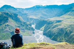
The coast was wild, and there were many birds there. We walked the grassy plains and sometimes on the beaches, and the path was practically flat for 5 km (return trip) towards Ker and the Landsendahorn cliff.
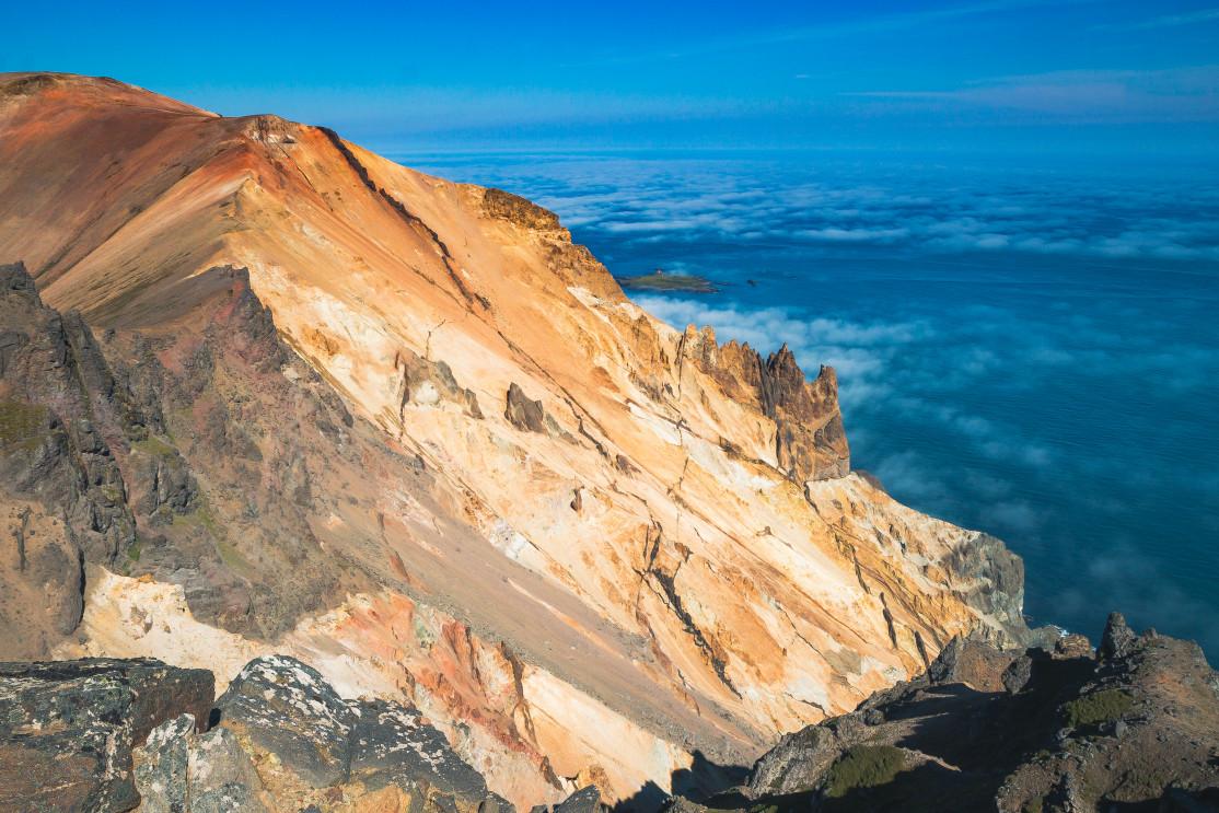
At the end of the hike were 200 to 300-meter-high cliffs and suspended rocky slopes called Móvíkurflug. The rock consisted mainly of rhyolite displaying several colors but mostly rich yellow, light brown, and green-gray hues.
It was a fun and relaxed drive but we were under a thick fog for a while that would completely clear up as we continued on Road 917.
The Therribjörg hiking trail

A nice surprise awaited us when we reached the high-point of 917: the clouds cleared entirely and the view that opened up of the Dyrfjöll near Bakkagerdi was just incredible.
After the endless shoelaces lay our second long walk of the day, the hike to the Therribjörg cliffs (or Therribjarg sometimes...). But first we had to drive down a small unmarked mountain road for a few kilometers before arriving at the car park with the hiking trail departure. The few kilometers of this drive (Hellisheiði Eystri) were a challenge, with short but very steep climbs on a very bumpy and stony path on which our Duster sometimes struggled because of the large stones coming up against the low ground clearance of our 4*4 at times.
The hiking trail added up to more than 10 km round trip, and we found it hard going, being very hilly, but the vista made it all worth the effort. The trail was very poorly marked however and we sometimes had to look hard to find the little green pegs to know which way to go...
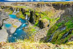
The trail first went downhill heading northeast on a rocky strip for about 2 km before arriving near a stream. We were then between two mountains:
- Múlafjall, green and black, 572 m
- Kullumúlagil, orange-yellow, 522 m

The path passed along the stream through the grassy riverside to climb between the two peaks. We could go down to the beach at the foot of the two cliffs of Therribjörg, or go up to the orange summit to enjoy a bird's-eye view of the cliffs.
When we reached the top, the view blew us away. The colors opposite our viewpoint on the heights of Bakkagerdi were indeed stupefying. The contrasts were so incredibly beautiful framed by the big blue sky that we were lucky enough to have all afternoon.
After admiring and photographing the cliffs for a long moment we took the opposite path to return to the car park, and the return was a bit of a struggle with the fatigue after our morning hike...
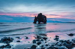
Ljósastapi Rock on Skjólfjörur Beach

Back at the car park, we continued with the other side of Road 917, going back down towards Vopnafjörður. On the road, we stopped at Skjólfjörur beach where a small path went right down to the sand.
It was still over 20 °C, the beach was deserted so we rested a bit to admire the rock formations rising from the sea, especially the famous "elephant rock" of Ljósastapi.
It was almost 8PM when we arrived in Seyðisförður after a good day of walking. This evening we were going to eat at Kaffi Lara - El Grillo Bar, probably the best deal for dinner in town. The cuisine was simple but tasty, especially the mutton, which was reputed to be excellent.