6°


 03 July 2012
One Day in Askja

A long journey awaited us that day, and thankfully the weather was once again mild. Chiki kindly offered to fill up the tank before we left for Askja, warning me that we needed to count half a tank of fuel for the trip.
The F910 to Askja was quite an adventure. The road from Aðalból to Brù was smooth and in good condition, taking only 10 minutes. The 23 km after Brù to the junction with the 905 were clearly more rugged, with some sections being stony and others sandy, and some passages that I would describe more as big puddles rather than real fords.
It took us 40 minutes from Brù to the crossing, where we took a break to admire the magnificent panorama that surrounded us. As we left, three large 4x4s of Italian tourists overtook us. A few kilometers further on, still heading south on the 910, we saw the three 4x4s about to cross the first ford. After checking, they passed without problems and kindly waited for us on the other side.
The F910 and its fords

The ford was about 30-40 cm deep and despite a little apprehension, the Jimny switched without difficulties to four wheel drive. Only 1 kilometer later, the second ford appeared. The Italians passed by without much question, but then again it wasn't surprising given the size of their vehicles...
I stopped to see the best way to understand the ford, which seemed narrower but deeper. In any case, the water was cloudy, and I couldn't see the bottom too well. The Italians were waiting for us on the other side, so we took the plunge.
The ford was a good 40 cm deep, but again, without any difficulties for our Jimny. In the end, these were the only two fords to Askja, the rest being just “big puddles”.
River crossings: a few precautions. River levels change with snowmelt and rain, so the 30 to 40 cm we found are not guaranteed on another day. Always check the best line before committing. According to Epic Iceland, water flow also decides which track is easiest: when the water is high, the F910 from the east is preferable because the Lindaá on the F88 can become dangerous; when it is low, the F88 is smoother. You may also come across bridges closed by a gate: open it, cross, then close it behind you.
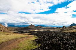
On the path to Askja, the road got worse and worse. It took a long time to make any progress, and it was not unusual to be moving at 30 km/h, despite some sections of more sandy roads that were easier to drive where we got up to 60 km/h for a few minutes. The road to the shelter was sometimes rough and stony, sometimes sandy, but always spectacularly beautiful! A superb trail in a wild landscape...
We arrived in Drekagil near the shelter after 2H30 on the trail. We then had “only” 8 km left to reach the Öskjuvatn car park where we could begin the hike to the crater. The off-road trail was very much off-road, and we arrived at the car park after 2 hours 45 minutes of incessant bouncing. We took the opportunity to picnic before the hike on foot. It was a 30-minute walk to reach Viti and Öskjuvatn, an easygoing trail with patches where we had to walk several hundred meters in the snow.
Good to know at Drekagil and Vikraborgir. In summer, national park rangers are stationed at Drekagil, where there is a campsite, a hut (55 beds) and toilets with showers. The Vikraborgir car park, at the end of the F894, has toilets. There are no shops, restaurants or gas stations at Askja, so bring fuel, food and warm clothes. The trail from Vikraborgir to Öskjuvatn (2.5 km, about 2 hours return according to the park) is rated easy and marked with yellow poles, but it can become unpleasant in fog, rain or wind. The Drekagil ranger can also tell you about the condition of the trail and the activity of the volcano.
The majestic scenery of Askja

Askja was truly awe-inspiring. The weather was clear but quite cold (about 8°) up here in the mountains... Once there, the contrast between the water of Viti and that of Öskjuvatn was impressive, and a smell of sulfur emanated from Viti that was quite overpowering.
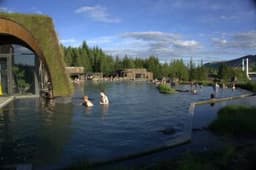
A tourist also took the opportunity to go down into the crater to swim. The descent was on the left side, but it was rather difficult because it was steep and slippery. We stayed on site for about an hour, strolling between the two lakes and contemplating the exceptional panorama.
Swimming in Víti: be careful. According to Vatnajökull National Park, the water in the crater is usually above 20°C, but the path down is very slippery when wet, the mud at the bottom can be hot (especially on the eastern bank) and rocks can fall from the edges. There are no lifeguards, so stay close to the shore. Before going down, ask the ranger at Drekagil for advice, as the descent may be discouraged depending on the state of the path (wooden crosses sometimes mark a closed access).
We took several breaks on Road 910 back to Brù; this track was, along with the F225, one of my favorites. Furthermore, we finally arrived around 04:00PM at the intersection with Road number 1 to reach Seyðisfjorður (Additional information about Seyðisfjorður) where we stayed overnight at the Aldan Hotel.
This village buried at the bottom of the fjord is really very nice. We took a walk to the center before dinner as there is a lot of activity here, especially in the water where young people enjoy kayaking in the late afternoon.
Places to see around Askja
If you have more time in the area, several sights can be reached from the same tracks:
- the flat-topped Herðubreið volcano, which dominates the F88;
- the Laugarvellir hot waterfall, at the southern end of the F910;
- the Kverkfjöll mountains, south of Askja;
- the Holuhraun lava field, formed in the 2014 eruption.