10°


 24 June 2006
Snaefellsnes Peninsula

- Day: Saturday, June 24
- Weather: Cloudy, 12 °C
- Distance in kilometers: 320 km
The Avis agency picked us up at the Alba Guesthouse at 9AM so that we could pick up our 4x4. We had thought we would find a Suzuki Jimny as originally planned, but they didn't have one anymore, so we rented a Hyundai Santa Fe for the same price.
Once we got used to the automatic gearbox we hit the road towards Mosfellsbaer. First, we took a short break outside Reykjavik to take photos of the Laugasfell church.
Road 47, which runs along Esja, was magnificent, with a beautiful view of Hvalfjöður in particular. Our afternoon was partly devoted to a walk to the Eldborg volcano. We parked the car at the farm where the path leading to the crater began.
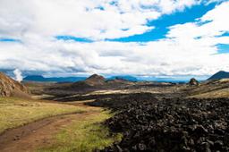
We crossed the lava fields covered in moss on foot before arriving at a rather impressive crater. It took about 2 hours to make the return trip hiking from the farm; the ascent of the crater itself took only 20 minutes, but the “path” was very steep and often slippery.
If you want to plan this walk: the trail starts at the Snorrastaðir farm, reached by a small side road off Road 54, where you will find a car park and toilets. Access is free and the trail is open all year round. It is about 6.6 km round trip over uneven volcanic rock with high steps, and chains help you climb the last part of the ascent. Bring sturdy shoes and water, and stay on the path to protect the moss, which grows back very slowly. The basalt cliffs of Gerðuberg are only a few minutes away by car and make an easy extra stop.
On the way back, we found ourselves in the middle of the herd of cows from the neighboring farm who all began rushing towards the open gate to get out of their enclosure while we did; the race was on but unfortunately for them, we were faster...
We headed for the Snaefellsnes peninsula and stopped at the Ytri Tunga farm on Chris's advice. (Good to know: parking at the seal beach is now paid, at 900 ISK per vehicle of up to 5 people, and free for a visit of less than 10 minutes; you can pay on site or online.)

Hellnar and its cliffs
In fact, just 200 meters behind the farm, there was a beach where we easily found a seal colony enjoying some sun rays. Slowly and silently we managed to get very close to them to take a few shots. Surprisingly, our discreet presence didn't seem to bother them too much; they didn't pay too much attention to us, just casting a quick glance from time to time.
A few kilometers away, we made a stop at the church in Buðir, which has the unique feature of being all black. Our journey ended in Arnarstapì, where we found our guesthouse (Snjöfell). The road offered magnificent landscapes, with mountains adorned in red and ocher colors.
Buðir is little more than this black wooden church and a country hotel, set in the middle of the Búðahraun lava field, close to a pale sandy beach dotted with black lava rocks. The current church dates back to a building permit granted in 1849; it was restored in 1951, then moved slightly and rebuilt in the 1980s following its original Danish plan. The stop is free, open at any time, and 15 to 30 minutes is plenty.
The village of Arnarstapì was very charming, complete with a picturesque little port, and the locals we met there were exceptionally friendly. Close to the stone statue, which represented a Viking, there was a lovely hiking trail leading to Hellnar (2.5km).
Upon reaching Hellnar, we discovered a delightful little café where we could take a short break before continuing our journey. Additionally, on a pebble beach in Hellnar, there were breathtaking rocks forming an arch and providing a home to numerous bird species. The black rocks beautifully contrasted with the sublime turquoise blue of the water. After savoring a delicious meal at the restaurant in the Snjöfell guesthouse, we called it a day and decided to get some rest.
If you have more time in the area, several sites around Arnarstapi are worth a detour: the full Arnarstapi to Hellnar hike, the Rauðfeldsgjá canyon on the road from Búðir, the black pebble beach of Djúpalónssandur and the Kirkjufell mountain on the north coast. A complete guide to the Snaefellsnes peninsula would place them all on the map.